Weather
Humid, Hot Weather Is On Its Way To Twin Cities
Minnesota is apparently skipping spring this year.

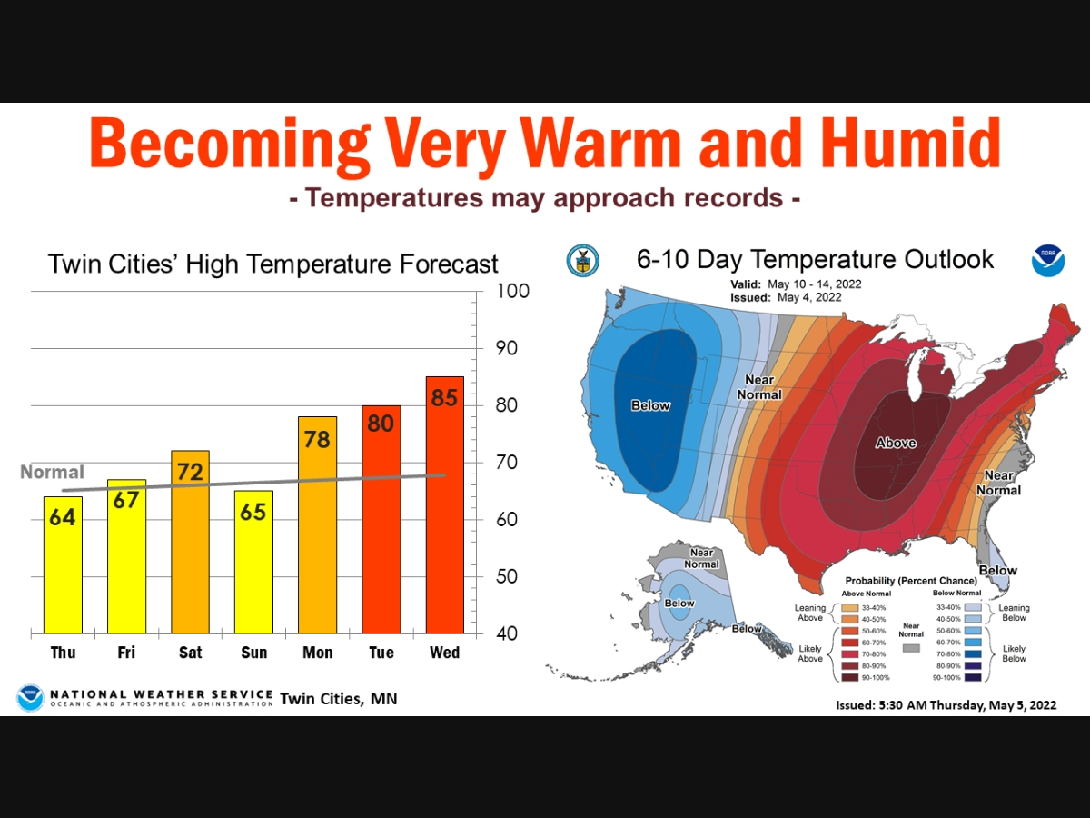
TWIN CITIES, MN — Minnesota is apparently skipping spring this year. Following a cold April and start to May, things are about to heat up, and fast. Temperatures will inch closer to 90 degrees next week.
"The weather pattern will become much warmer and more humid by next week with several chances of thunderstorms," the National Weather Service said.
"Some storms may be severe, particularly on Monday when a risk area covers much of the Upper Mississippi Valley. Temperatures will warm into the 70s and 80s, but there are indications that even some 90s are possible. Record highs for next week range from the upper 80s to lower 90s."
Find out what's happening in Southwest Minneapolisfor free with the latest updates from Patch.
Here’s the full NWS forecast from the Minneapolis-St. Paul International Airport:
Thursday: Mostly cloudy, with a high near 64. East southeast wind around 5 mph.
Find out what's happening in Southwest Minneapolisfor free with the latest updates from Patch.
Thursday Night: Mostly cloudy, with a low around 47. Northeast wind around 5 mph.
Friday: Sunny, with a high near 66. East wind 5 to 10 mph.
Friday Night: Partly cloudy, with a low around 47. East southeast wind 5 to 10 mph.
Saturday: Mostly sunny, with a high near 72. Southeast wind 10 to 15 mph.
Saturday Night: A 30 percent chance of showers after 1am. Mostly cloudy, with a low around 53. Southeast wind around 15 mph.
Sunday: Showers likely and possibly a thunderstorm. Mostly cloudy, with a high near 65. South southeast wind around 15 mph. Chance of precipitation is 70%.
Sunday Night: Showers likely and possibly a thunderstorm. Mostly cloudy, with a low around 57. East southeast wind 10 to 15 mph. Chance of precipitation is 60%.
Monday: A 40 percent chance of showers and thunderstorms. Mostly cloudy, with a high near 78. East southeast wind around 15 mph, with gusts as high as 35 mph.
Monday Night: A 40 percent chance of showers and thunderstorms, mainly before 1am. Partly cloudy, with a low around 60. South wind 5 to 15 mph becoming east southeast after midnight. Winds could gust as high as 25 mph.
Tuesday: A 30 percent chance of showers and thunderstorms. Mostly sunny, with a high near 80. East southeast wind around 10 mph.
Tuesday Night: A 40 percent chance of showers and thunderstorms. Partly cloudy, with a low around 60. East northeast wind around 10 mph.
Wednesday: A 40 percent chance of showers and thunderstorms. Partly sunny, with a high near 85. East southeast wind 10 to 15 mph.
Get more local news delivered straight to your inbox. Sign up for free Patch newsletters and alerts.


