Weather
10 Inches Of Snow Possible In Twin Cities
The snow will make travel difficult Wednesday throughout central Minnesota. Another snowstorm is expected to arrive this weekend.

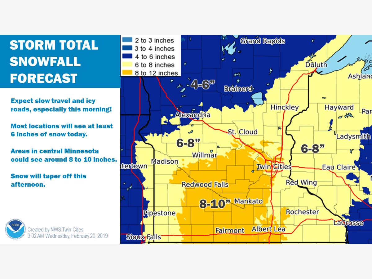
TWIN CITIES, MN — Wednesday will feature heavy snow, icy roads, and slow travel. A winter storm warning is in effect in all of central and southern Minnesota.
Some parts of central Minnesota could see up to 10 inches of snow fall today, including the Twin Cities metro. Expect extremely difficult morning and evening commutes.
Reminder: A winter storm warning means motorists should expect severe conditions that will make traveling hazardous, if not impossible. Be sure to keep a flashlight, food and water in your car in the case of an emergency.
Find out what's happening in Southwest Minneapolisfor free with the latest updates from Patch.
The storm will end Wednesday night. However, February isn't done with the snow yet. Another snowstorm is expected to arrive in Minnesota this weekend.

"Confidence continues to increase a winter storm will impact much of the central Plains to northern Great Lakes this weekend," says the National Weather Service.
Find out what's happening in Southwest Minneapolisfor free with the latest updates from Patch.
"The best chance for heavy snow accumulations will be across the southern and eastern MN into western and northern WI from late Saturday into early Sunday."

Minnesota Department of Transportation snowplow operators will do their part to make highways safe and motorists should remember to:
- Stay alert for snowplows, which turn or exit frequently and often with little warning. They also may travel over centerlines or partially in traffic to further improve road conditions.
- Stay back at least 10 car lengths behind the plow. Don't drive into a snow cloud.
- Slow down to a safe speed for current conditions.
- Turn on your headlights and wear your seat belt.
- Turn off the cruise control.
- Be patient and remember snowplows are working to improve road conditions for your trip.
- Don't drive distracted.
This month has already set records for daily and monthly snowfall totals, and it could set more. The Twin Cities metro is just shy of breaking the all-time record for February snowfall.
Find the metro's all-time snowfall records for February, provided by the NWS, below:
(Accurate as of Tuesday, Jan. 19.)
- 26.5 inches (1962)
- 24.2 inches (1909)
- 23.7 inches (1967)
- 22.6 inches (2019) - could rise to no. 1 all-time this week
- 19.7 inches (2004, 1936)
- 18.4 inches (2014
- 17.8 inches (1893
- 17.3 inches (1989)
- 16.5 inches (2001)
Check out the Twin Cities, Minnesota weather forecast below:
Today: Snow. The snow could be heavy at times. High near 29. East wind 5 to 15 mph becoming southwest in the afternoon. Chance of precipitation is 100 percent. Total daytime snow accumulation of 6 to 10 inches possible.
Tonight: A 40 percent chance of snow, mainly before 7pm. Mostly cloudy, with a low around 12. West wind 5 to 10 mph.
Thursday: Partly sunny, with a high near 24. West southwest wind around 5 mph.
Thursday Night: A 20 percent chance of snow after midnight. Mostly cloudy, with a low around 13. West southwest wind around 5 mph becoming calm in the evening.
Friday: A 30 percent chance of snow after noon. Mostly cloudy, with a high near 31. Southeast wind 5 to 10 mph.
Friday Night: Snow before 2am, then snow likely, possibly mixed with freezing drizzle. Low around 26. Southeast wind 5 to 10 mph. Chance of precipitation is 80 percent. New snow accumulation of 1 to 2 inches possible.
Saturday: Snow likely, mainly after noon. Cloudy, with a high near 34. East wind 5 to 10 mph becoming north northeast in the afternoon. Chance of precipitation is 60 percent.
Saturday Night: Snow. The snow could be heavy at times. Patchy blowing snow after 3 a.m. Low around 23. Blustery, with a north wind 10 to 20 mph, with gusts as high as 30 mph. Chance of precipitation is 90 percent.
Sunday: A 30 percent chance of snow, mainly before noon. Mostly cloudy, with a high near 26. Blustery, with a west northwest wind 15 to 20 mph, with gusts as high as 30 mph.
Sunday Night: Mostly cloudy, with a low around 3. Northwest wind 10 to 15 mph, with gusts as high as 25 mph.
Monday: Partly sunny, with a high near 16. Northwest wind 5 to 10 mph.
Monday Night: A 40 percent chance of snow. Mostly cloudy, with a low around 6. North wind around 5 mph.
Tuesday: A 30 percent chance of snow. Mostly cloudy, with a high near 19. North wind 5 to 10 mph.
Get more local news delivered straight to your inbox. Sign up for free Patch newsletters and alerts.