Weather
Minnesota Weather: 3 Inches Of Snow Possible In Twin Cities Metro
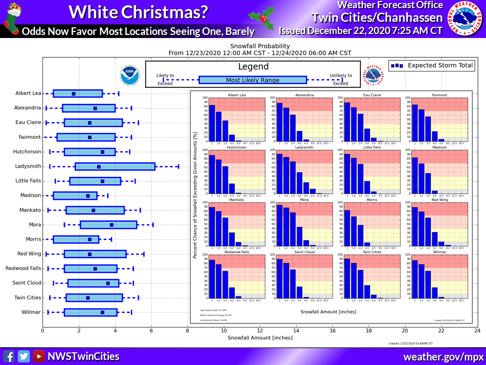
The Minneapolis-St. Paul metro area may be in for a white Christmas after all.


TWIN CITIES, MN — The Minneapolis-St. Paul metro area might be in for a white Christmas after all. Confidence is increasing that up to three inches of snow could fall in the Twin Cities Wednesday.
Much of central Minnesota — including the metro — is "expected to see an inch or more of snowfall Wednesday into Wednesday evening, along with plummeting temperatures," states the National Weather Service.
"This would result in at least an inch of snow on the ground for Christmas morning, which would officially make it a white Christmas."
Find out what's happening in Southwest Minneapolisfor free with the latest updates from Patch.
Here is an animation showing current forecast chance of exceeding a trace, 1", 2", 4", and 6" of snowfall with the system tomorrow. #mnwx #wiwx pic.twitter.com/GwJHkneq3U
— NWS Twin Cities (@NWSTwinCities) December 22, 2020
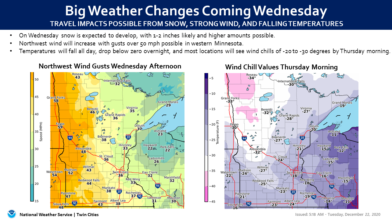
A deep cold will also settle in this week. The low on Wednesday will be 1. The low on Thursday will be 4 degrees below zero in the metro.
Here's the full NWS forecast for the Twin Cities metro area:
Find out what's happening in Southwest Minneapolisfor free with the latest updates from Patch.
Wednesday: Snow likely, possibly mixed with rain, becoming all snow after 1pm. Patchy blowing snow after 3pm. Mostly cloudy, with a temperature falling to around 16 by 5pm. Breezy, with a west northwest wind 15 to 25 mph, with gusts as high as 35 mph. Chance of precipitation is 70%. New snow accumulation of 1 to 3 inches possible.
Wednesday Night: A 40 percent chance of snow before midnight. Patchy blowing snow before 3am. Mostly cloudy, with a low around 1. Wind chill values as low as -15. Blustery, with a northwest wind 15 to 20 mph, with gusts as high as 30 mph.
Thursday: Mostly sunny and cold, with a high near 5. Northwest wind around 15 mph.
Thursday Night: Mostly clear, with a low around -4. West northwest wind 5 to 10 mph.
Christmas Day: Sunny, with a high near 21. West southwest wind around 5 mph.
Friday Night: Mostly clear, with a low around 12. Calm wind becoming west around 5 mph.
Saturday: Partly sunny, with a high near 27. Calm wind becoming south southwest around 5 mph.
Saturday Night: Mostly cloudy, with a low around 16. Calm wind becoming north northeast around 5 mph after midnight.
Sunday: Mostly cloudy, with a high near 24. North wind 5 to 10 mph.
Sunday Night: Mostly cloudy, with a low around 8. North northwest wind around 5 mph.
Monday: Mostly sunny, with a high near 18. Northwest wind around 5 mph.
Get more local news delivered straight to your inbox. Sign up for free Patch newsletters and alerts.


