Weather
Minnesota Weather: 5 Inches Of Snow Possible Tuesday In Metro
The National Weather Service has issued a winter weather advisory for most of central Minnesota, including all of the Twin Cities metro.

TWIN CITIES, MN — Minnesota drivers should prepare for snow-covered roads during the Tuesday morning commute, making travel difficult. The National Weather Service has issued a winter weather advisory for much of the state of Minnesota, including all of the Twin Cities metro area.
Snowfall amounts of 2 to 5 inches are possible in the Minneapolis-St. Paul metro.
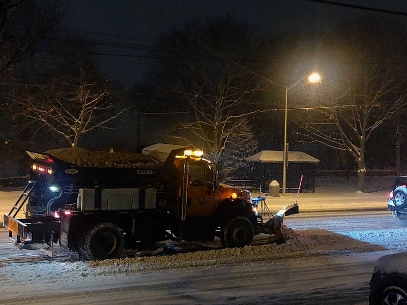
"Motorists need to be prepared for changing road conditions to be sure their drive is safe and uneventful," said Steve Lund, MnDOT maintenance engineer, in a news release.
Find out what's happening in Southwest Minneapolisfor free with the latest updates from Patch.
"When driving near snowplows, remember to be patient and give our operators plenty of room to work so that they can improve road conditions and help you get where you need to be."
Transit officials recommend that everyone traveling in a vehicle be dressed for the cold weather.
Find out what's happening in Southwest Minneapolisfor free with the latest updates from Patch.
Here's approximate timing of when the snow will start. The "blues" are early Tuesday morning, and the "reds" are late Tuesday morning #mnwx #wiwx pic.twitter.com/KVqnwBYLaG
— NWS Twin Cities (@NWSTwinCities) October 19, 2020
Remember to be on the lookout for snowplows, and always stay back at least 10 car lengths behind the plow. "Don’t drive into a snow cloud," MnDOT says.
Here's the NWS forecast for the Twin Cities metro area:
Monday Night: Mostly cloudy, with a low around 29. Calm wind becoming southeast around 5 mph after midnight.
Tuesday: Snow, mainly after 9am. The snow could be heavy at times. High near 35. Southeast wind 5 to 10 mph. Chance of precipitation is 100%. New snow accumulation of 3 to 5 inches possible.
Tuesday Night: Drizzle and snow likely, mainly before 9pm. Mostly cloudy, with a low around 32. South southeast wind 5 to 10 mph becoming west after midnight. Chance of precipitation is 70%. New snow accumulation of less than one inch possible.
Wednesday: A 20 percent chance of rain after 1pm. Mostly cloudy, with a high near 39. West wind around 5 mph.
Wednesday Night: A slight chance of rain and snow before 1am, then a chance of rain. Mostly cloudy, with a low around 33. Light east southeast wind becoming east 5 to 10 mph after midnight. Chance of precipitation is 40%.
Thursday: Rain, with thunderstorms also possible after 4pm. High near 46. East wind 10 to 15 mph. Chance of precipitation is 90%. New rainfall amounts between a half and three quarters of an inch possible.
Thursday Night: Rain likely before 5am, then a chance of rain and snow. Some thunder is also possible. Mostly cloudy, with a low around 34. North wind around 10 mph. Chance of precipitation is 60%. Little or no snow accumulation expected.
Friday: A chance of rain and snow, mainly before 7am. Mostly cloudy, with a high near 38. Northwest wind 10 to 15 mph. Chance of precipitation is 30%.
Friday Night: Partly cloudy, with a low around 23. Northwest wind 5 to 10 mph.
Saturday: Partly sunny, with a high near 36. Northwest wind around 5 mph becoming northeast in the afternoon.
Saturday Night: A 20 percent chance of snow. Mostly cloudy, with a low around 29. East northeast wind around 5 mph.
Sunday: A chance of rain and snow. Mostly cloudy, with a high near 37. East wind around 5 mph. Chance of precipitation is 40%.
Sunday Night: A chance of rain and snow. Mostly cloudy, with a low around 28. North wind around 5 mph. Chance of precipitation is 30%.
Monday: A chance of rain and snow. Mostly cloudy, with a high near 35. Northwest wind 5 to 10 mph. Chance of precipitation is 30%.
Get more local news delivered straight to your inbox. Sign up for free Patch newsletters and alerts.


