Weather
Minnesota Weather: 13 Inches Of Snow Possible In Twin Cities
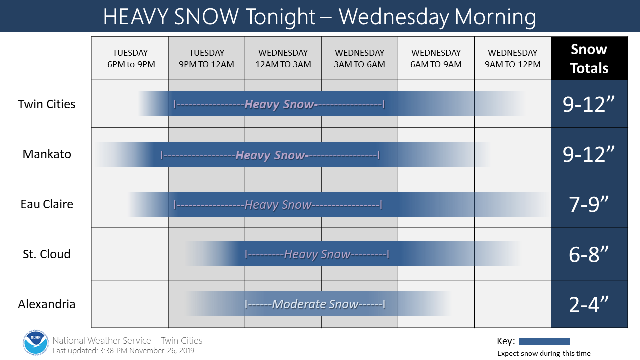
Check out a timeline of the major snowstorm set to hit Minnesota just as people are beginning to travel for Thanksgiving.


TWIN CITIES, MN — The snowstorm expected to disrupt Thanksgiving travel in Minnesota has been upgraded Tuesday, hours before it's set to hit the Minneapolis-St. Paul metro area. The National Weather Service has issued a winter storm warning in effect for most of central Minnesota and all of southern Minnesota.
Snowfall totals of 6 or more inches are likely in the warned area, with snow amounts of up to 13 inches possible in the Twin Cities.
Be prepared for gusty northeast winds, reaching 40 MPH, causing blowing snow. Travel will be extremely difficult in Minnesota "through at least Wednesday morning," says the National Weather Service.
Find out what's happening in Southwest Minneapolisfor free with the latest updates from Patch.
"Heavy snow begins this evening and lasts into Wednesday morning. The heaviest snow is expected overnight. Travel conditions will be hazardous tonight through Wednesday morning."
Subscribe to Patch for news alerts in your area.
Find out what's happening in Southwest Minneapolisfor free with the latest updates from Patch.
Some travelers may have to alter their plans.
It looks like snow will be arriving just in time for one of our busiest travel weeks! So far, only @Delta has issued a weather waiver for MSP. If Minnesota decides to flip its switch to "winter," please confirm your flight's status with your airline before heading to the airport.
— MSP Airport (@mspairport) November 25, 2019
The National Weather Service has provided a timeline for when and where the snowstorm will hit:
If you're in the state, you can find out the latest road conditions in Minnesota by calling 511. If you have to travel, weather officials recommend you keep an extra flashlight, food, and water in your car in the case of an emergency.
Related: Stay Warm On The Go With These Cold Weather Essentials
Here's the updated NWS forecast for the Twin Cities. Stay with Patch as the storm approaches:
Tonight: Snow, mainly after 7 p.m. The snow could be heavy at times. Some thunder is also possible. Patchy blowing snow after midnight. Low around 29. Blustery, with a northeast wind 15 to 25 mph, with gusts as high as 35 mph. Chance of precipitation is 100 percent. Total nighttime snow accumulation of 8 to 12 inches possible.
Wednesday: Snow, mainly before noon. Patchy blowing snow before noon. Temperature falling to around 28 by 5pm. Blustery, with a north northwest wind 20 to 25 mph decreasing to 15 to 20 mph in the afternoon. Winds could gust as high as 40 mph. Chance of precipitation is 100 percent. New snow accumulation of 1 to 3 inches possible.
Wednesday Night: Partly cloudy, with a low around 15. North northwest wind 5 to 10 mph becoming light after midnight.
Thanksgiving Day: A 20 percent chance of snow after noon. Mostly cloudy, with a high near 28. Calm wind.
Thursday Night: A 30 percent chance of snow. Cloudy, with a low around 25. Calm wind becoming southeast around 5 mph after midnight.
Friday: Snow likely, mainly after noon. Cloudy, with a high near 35. Southeast wind 5 to 10 mph. Chance of precipitation is 70 percent. New snow accumulation of 1 to 3 inches possible.
Friday Night: Snow before midnight, then rain and snow. Low around 33. East southeast wind 10 to 15 mph, with gusts as high as 30 mph. Chance of precipitation is 90 percent. Little or no snow accumulation expected.
Saturday: Rain and snow before 3 p.m., then rain between 3 p.m. and 5 p.m., then rain and snow after 5 p.m. High near 38. East wind 10 to 15 mph, with gusts as high as 30 mph. Chance of precipitation is 80 percent.
Saturday Night: Rain and snow, becoming all snow after 8 p.m. Low around 28. Northeast wind around 10 mph. Chance of precipitation is 80 percent.
Sunday: A 40 percent chance of snow, mainly before noon. Mostly cloudy, with a high near 30. North wind 10 to 15 mph.
Sunday Night: Partly cloudy, with a low around 16. North northwest wind 5 to 10 mph.
Monday: Mostly sunny, with a high near 25. West wind around 5 mph.
Monday Night: Mostly cloudy, with a low around 18. West southwest wind around 5 mph.
Tuesday: Partly sunny, with a high near 29. West wind around 5 mph.
Travel
Motorists should prepare for snow-covered and icy road conditions in portions of Minnesota beginning Tuesday afternoon as a winter storm is expected to bring significant snow and wind to the region through Wednesday morning, which means Thanksgiving travel could be difficult.
The Minnesota Department of Transportation encourages motorists to check 511mn.org before they travel to see current road conditions and view highway and snowplow cameras along their route.
Hundreds of snowplow operators will be working during the winter storm, so motorists should remember to stay back at least 10 car lengths and use extra caution when driving near snowplows.
"We want motorists to be prepared for the changing road conditions to be sure their drive is safe and uneventful this holiday weekend," said Jed Falgren, acting MnDOT state maintenance engineer, in a news release.
"When driving near snowplows, motorists should remember to be patient and give our operators room to work so that they can improve road conditions."
Move over for emergency vehicles
Working on the side of the road can be challenging for any emergency responder, but responding during inclement weather can be even more challenging.
- When traveling on a road with two or more lanes, drivers must keep one full lane away from stopped emergency vehicles with flashing lights activated — ambulance, fire, law enforcement, maintenance, construction vehicles and tow trucks.
- Reduce speed if unable to safely move over a lane.
- Failing to take these actions endangers personnel who provide critical and life-saving services. Fines can exceed $100.
"Please help keep us safe on the road by always putting the distractions away, focusing on the road and always moving over for emergency vehicles," said Lt. Gordon Shank, Minnesota State Patrol.
"Remember, this will not only keep emergency responders safe on the road, but it’ll keep you and your loved ones safe as well."
Motorists should also remember to:
- Don’t drive distracted.
- Stay alert for snowplows, which turn or exit frequently and often with little warning. They also may travel over centerlines or partially in traffic to further improve road conditions.
- Stay back at least 10 car lengths behind the plow. Don’t drive into a snow cloud.
- Slow down to a safe speed for current conditions.
- Turn on your headlights and wear your seat belt.
- Turn off the cruise control.
- Be patient and remember snowplows are working to improve road conditions for your trip.
Get more local news delivered straight to your inbox. Sign up for free Patch newsletters and alerts.


