Sports
'High-Impact' Snowstorm Headed For Twin Cities
Two different storms are forecasted to drop several more inches of snow on the Twin Cities and central Minnesota.


TWIN CITIES, MN — Two more rounds of snow are headed for central Minnesota, including a large storm arriving Monday. Up to 4 inches of snow are possible Sunday, while 7 inches are possible Monday.
More heavy snow will likely fall Tuesday.
"Forecasts are trending towards the possibility for another high-impact winter storm Monday night through Tuesday," says the National Weather Service.
Find out what's happening in Southwest Minneapolisfor free with the latest updates from Patch.
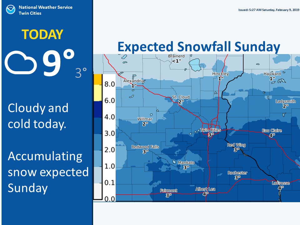
Snow totals
Below are the NWS snowfall amounts from this past week's winter storm:
Find out what's happening in Southwest Minneapolisfor free with the latest updates from Patch.
- MSP: 6.3 inches
- Chanhassen: 5.5 inches
- St. Cloud: 6.1 inches
- Eau Claire: 6.6 inches
After grass and dirt were starting to show in the metro, the storm increased the snow depth considerably. Check out the current snow depths below:
- Duluth: 25 inches
- International Falls: 24 inches
- Brainerd: 18 inches
- St. Cloud: 14 inches
- Eau Claire: 11 inches
- Twin Cities: 9 inches
The forecast continues to trend towards a potential high-impact winter storm Monday night through Tuesday. The heaviest snowfall is expected from southern & eastern Minnesota through western Wisconsin. Continue to monitor https://t.co/yPlO9paDul for the latest info#mnwx #wiwx pic.twitter.com/mKLnfFaXUu
— NWS Twin Cities (@NWSTwinCities) February 9, 2019
Check out the Twin Cities, Minnesota weather forecast below:
Sunday: Snow. High near 18. East northeast wind around 5 mph. Chance of precipitation is 90 percent. New snow accumulation of 2 to 4 inches possible.
Sunday Night: A 20 percent chance of snow before midnight. Mostly cloudy, with a low around 12. East northeast wind around 5 mph.
Monday: A slight chance of snow and freezing rain between noon and 1pm, then a slight chance of snow after 1 p.m. Mostly cloudy, with a high near 26. East wind 5 to 15 mph. Chance of precipitation is 20 percent.
Monday Night: Snow. The snow could be heavy at times. Low around 22. East wind 10 to 15 mph. Chance of precipitation is 90 percent. New snow accumulation of 3 to 7 inches possible.
Tuesday: Snow. The snow could be heavy at times. High near 27. Northeast wind 10 to 15 mph becoming northwest in the afternoon. Chance of precipitation is 90 percent.
Tuesday Night: A 20 percent chance of snow before midnight. Mostly cloudy, with a low around 10. West northwest wind 10 to 15 mph.
Wednesday: Partly sunny, with a high near 20. West wind 5 to 10 mph becoming south in the afternoon.
Wednesday Night: Mostly cloudy, with a low around 9. East southeast wind around 5 mph.
Thursday: A 50 percent chance of snow. Mostly cloudy, with a high near 26. East southeast wind 5 to 10 mph becoming north northeast in the afternoon.
Thursday Night: Snow likely. Cloudy, with a low around 14. North wind 10 to 15 mph. Chance of precipitation is 70 percent.
Friday: A 30 percent chance of snow. Mostly cloudy, with a high near 20. North northwest wind around 15 mph, with gusts as high as 25 mph.
Image via National Weather Service
Get more local news delivered straight to your inbox. Sign up for free Patch newsletters and alerts.