Weather
Minnesota Weather: How Much Snow Fell Last Night?
The storm coated roads with snow and ice from southern Minnesota to the Twin Cities Saturday.


UPDATE, 10 a.m. Sunday — Light snow will end Sunday morning across central and southern Minnesota. No more than an inch or two of additional snowfall is expected today, according to the National Weather Service. Gusty winds may lead to areas of blowing and drifting snow.

More than seven inches of snow fell in parts of the Twin Cities metro over the weekend, including 7.5 in Lakeville, according to unofficial data.
Even more fell south of the metro. More than 10 inches of snow was reported in Madelia, Minnesota, located outside of Mankato.
Find out what's happening in Southwest Minneapolisfor free with the latest updates from Patch.
How much snow did you get? Here are some of the snowfall totals from across our area #mnwx #wiwx pic.twitter.com/r84PocRErv
— NWS Twin Cities (@NWSTwinCities) December 2, 2018
Subscribe to free Weather Alerts
UPDATE, 11 p.m. Saturday — Snow will continue to move in a counter-clockwise direction through the night, according to the National Weather Service. Another 2 inches may fall in certain parts of the Twin Cities metro by the morning.
Find out what's happening in Southwest Minneapolisfor free with the latest updates from Patch.
Be aware of icy and snowy roads and drive with extreme caution.
UPDATE, 2:45 p.m. — It's begun. The snowstorm that's already coated most of southern Minnesota Saturday morning has arrived in the Twin Cities metro.
Some of the heaviest snow will fall in the next two to three hours. Up to 5 inches will fall in the metro.
Read more about what's expected from the storm this weekend below:
@NWSTwinCities Let it snow! It's coming down in Farmington and winds are kicking up slowly. pic.twitter.com/ADaKVzE1PC
— JP Andersen (@jp_andersen1) December 1, 2018
Snow has officially hit #MSP ! #MNwx pic.twitter.com/PxOyvb0Cve
— Miranda Mair (@MirandaWX) December 1, 2018

TWIN CITIES, MN — A winter storm will hit southern and central Minnesota Saturday, including the Twin Cities metro. Total snow accumulations of 3 to 5 inches are expected in the Minneapolis-Saint Paul area, with winds gusting as high as 40 mph.
A winter weather advisory — lasting from noon Saturday to noon Sunday — has been issued for central Minnesota, including Wright, Hennepin, Anoka, Ramsey, Washington, Carver, Scott, and Dakota counties.
A winter storm warning has been expanded across southern Minnesota and is now in effect for locations along and south of a Madelia to Red Wing line, where 5 to 10 inches of snow is expected.
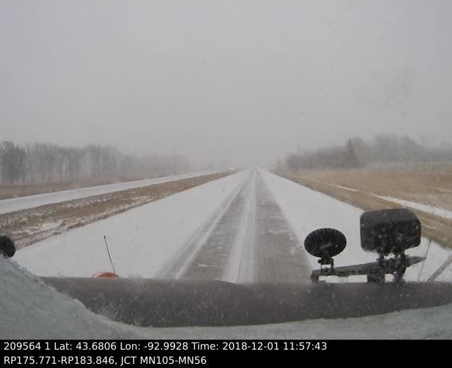
Here's a view from a plow camera in southern Minnesota (taken at 12 p.m. Saturday):
While MnDOT staff prepare for snow and ice control, motorists can also prepare for winter weather driving by following these steps:
- Allow extra time to get to your destination.
- Be patient behind the wheel and remember snowplows are working to improve road conditions.
- Stay back at least 10 car lengths behind a plow, far from the snow cloud.
- Stay alert for snowplows that turn or exit frequently and often with little warning. Anticipate that plows may also travel over centerlines or partially into traffic to further improve road conditions.
- Slow down to a safe speed for current conditions.
- No texting, emailing, or internet while driving – it’s the law.
The latest road conditions for Minnesota can be found at 511mn.org and for Wisconsin at 511wi.gov, or by calling 5 1 1 in either state.
Here's a specific look at when — and how much — snow will fall over the next 24 hours in Minnesota:


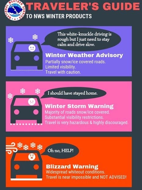
According to the National Weather Service, a winter weather advisory for snow "means periods of snow will cause primarily travel difficulties. Expect snow covered roads and limited visibilities, and use caution while driving."
A winter storm warning for snow means "severe winter weather conditions will make travel very hazardous or impossible. If you must travel, keep an extra flashlight, food and water in your vehicle in case of an emergency."
Hunker down by 2 pm! A wave of snow now in southern Minnesota moves north into MSP area by about 2-3 pm. Intensity will pick up quickly this afternoon so you may want to get errands done by around 2 pm. I'm still expecting 2" to 5" MSP, 5" to 10" southern MN. #mnwx pic.twitter.com/OHZjZg0sl0
— MPR Weather (@MPRweather) December 1, 2018
National Weather Forecast for the Twin Cities:
Today: Snow, mainly after 1 p.m. High near 34. Breezy, with a northeast wind 15 to 20 mph, with gusts as high as 30 mph. Chance of precipitation is 100 percent. Total daytime snow accumulation of less than one inch possible.
Tonight: Snow. Patchy blowing snow between 7 p.m. and 11 p.m. Steady temperature around 34. Breezy, with a north northeast wind 15 to 20 mph, with gusts as high as 30 mph. Chance of precipitation is 100 percent. New snow accumulation of 1 to 3 inches possible.
Sunday: Snow likely, mainly before noon. Cloudy, with a temperature falling to around 28 by 5 p.m. North wind around 15 mph, with gusts as high as 30 mph. Chance of precipitation is 60 percent. New snow accumulation of less than one inch possible.
Sunday Night: Mostly cloudy, with a low around 19. North wind around 10 mph.
MnDOT Urges Caution Around Snowplows
The Minnesota Department of Transportation is urging motorists to use extra caution during plowing and snow removal operations. MnDOT snowplows have already been involved in crashes with the public this year, the department said.
"Our snowplow operators are seeing inattentive drivers, motorists driving too close to the plow and motorists driving too fast for conditions," said Todd Stevens, acting state maintenance engineer, in a statement.
"These are the main causes of crashes with snowplows. Our drivers are well trained to drive their plows, but motorists should be patient, stay back from the plow and only pass when it is safe to do so."
Here are some other recommendations for safe driving around snowplows:
- Stay alert for snowplows, which turn or exit frequently and often with little warning. They also may travel over centerlines or partially in traffic to further improve road conditions.
- Stay back at least 10 car lengths behind the plow. Don't drive into a snow cloud.
- Slow down to a safe speed for current conditions.
- Turn on your headlights and wear your seat belt.
- Turn off the cruise control.
- Be patient and remember snowplows are working to improve road conditions for your trip.
- Don't drive distracted.
Sign Up For Patch's Daily Newsletter and Breaking News Alerts in Your Neighborhood
Image via National Weather Service
Get more local news delivered straight to your inbox. Sign up for free Patch newsletters and alerts.