Weather
Minnesota Weather: Polar Vortex 2019 Intensifies Wednesday
Wind chills could fall to 65 degrees below zero overnight. Spending any prolonged time outdoors could be extremely dangerous.

TWIN CITIES, MN — Frostbite or even death could occur if precautions aren't taken Tuesday night and Wednesday. The National Weather Service has issued a wind chill warning for the entire state of Minnesota that will last into Thursday.
"Dangerous wind chills of 45 below to 65 below zero are expected for most of the period from Tuesday night through Thursday morning," says NWS.
"This is a life-threatening situation for those spending any prolonged period outdoors without proper clothing."
Find out what's happening in Southwest Minneapolisfor free with the latest updates from Patch.
Most schools in Minnesota — as well as many businesses — will be closed Wednesday. The Unites States Postal Service has announced that it will suspend delivery operations.

Wind chills are expected to fall to 50 to 65 below by Tuesday night.
Find out what's happening in Southwest Minneapolisfor free with the latest updates from Patch.
National weather officials say record low temperatures are possible in the Twin Cities this week; the record for Wednesday is 30 below and the record for Thursday is 27 below.
So how common is it to get an air temperature of -30 or colder? Not very, especially since the 1980s! Here are graphs for -30 or colder counts every year on record for MSP (38 days), STC (94 days), and EAU (56 days). #mnwx #wiwx pic.twitter.com/ZbNHTuYKVf
— NWS Twin Cities (@NWSTwinCities) January 29, 2019
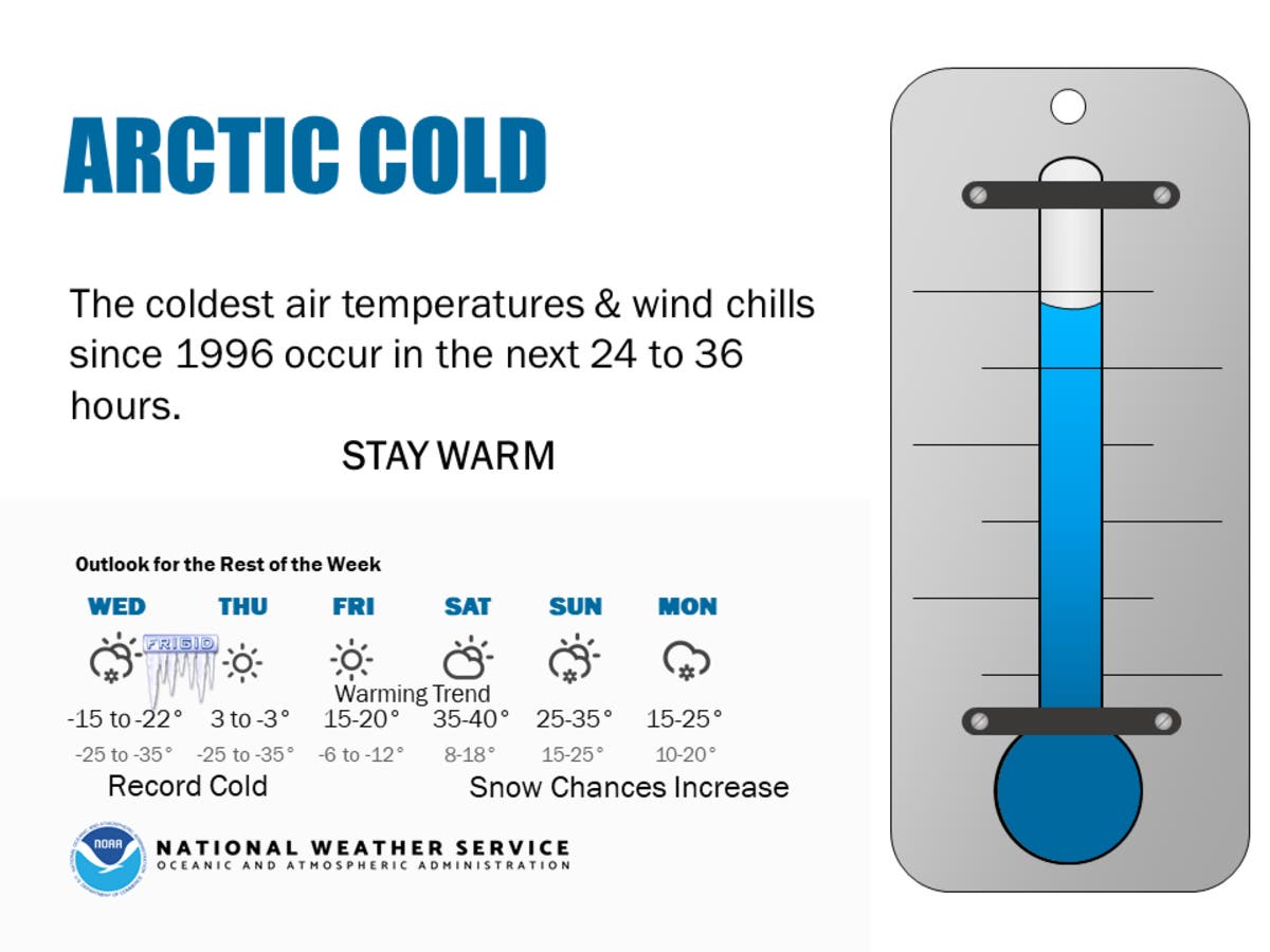
Here's the NWS forecast for the Twin Cities metro area:
Tuesday Night: Mostly cloudy, with a low around -28. Wind chill values as low as -53. Blustery, with a west northwest wind 15 to 20 mph, with gusts as high as 30 mph.
Wednesday: Sunny and cold, with a high near -15. Wind chill values as low as -52. West northwest wind 10 to 15 mph.
Wednesday Night: Mostly clear, with a low around -26. Wind chill values as low as -39. West wind around 5 mph becoming calm after midnight.
Thursday: A 50 percent chance of snow after noon. Mostly cloudy and cold, with a high near -4. Calm wind becoming southeast around 5 mph in the afternoon. New snow accumulation of less than a half inch possible.
Thursday Night: A 30 percent chance of snow before midnight. Mostly cloudy, with a low around -8. Southeast wind around 5 mph.
Friday: Partly sunny, with a high near 15. South southeast wind around 5 mph.
Friday Night: Partly cloudy, with a low around 11. South wind 5 to 10 mph.
Saturday: Partly sunny, with a high near 38. South wind 5 to 10 mph.
Saturday Night: Mostly cloudy, with a low around 26. South wind around 5 mph becoming north after midnight.
Sunday: A 30 percent chance of snow. Mostly cloudy, with a high near 34. North northeast wind 5 to 10 mph.
Sunday Night: Snow. Low around 19. Northeast wind around 10 mph. Chance of precipitation is 80 percent.
Monday: Snow likely. Cloudy, with a high near 24. North wind around 10 mph. Chance of precipitation is 70 percent.
Monday Night: Mostly cloudy, with a low around 6. Northwest wind around 10 mph.
Tuesday: Mostly cloudy, with a high near 15.
Image via National Weather Service
Get more local news delivered straight to your inbox. Sign up for free Patch newsletters and alerts.


