Weather
Minnesota Weather: Dangerously Cold Temperatures On The Way
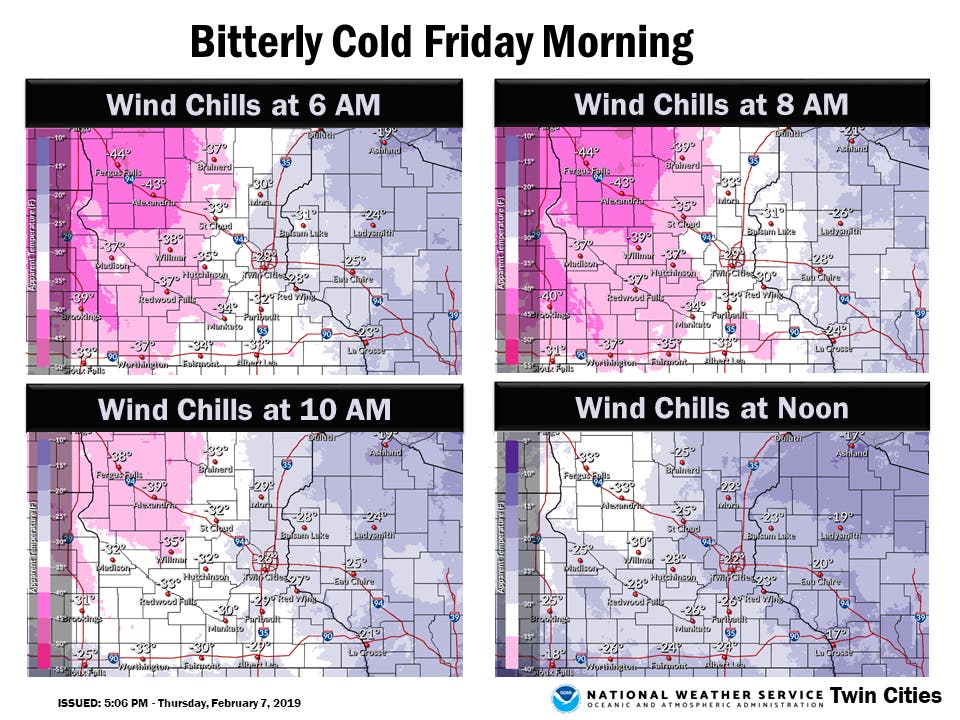
Wind chills Friday will fall to around 30 degrees below zero in the Twin Cities metro area.


TWIN CITIES, MN — As the heavy snow tapers off, motorists should expect blowing snow to continue to be a problem, with wind gusts reaching 35-45 mph. Blizzard conditions are possible.
Wind chills Friday will fall to at least 30 degrees below zero in the Twin Cities metro area.
The National Weather Service has issued a wind chill advisory for Mille Lacs, Kanabec, Sherburne, Isanti, Chisago, Wright, Hennepin, Anoka, Ramsey, Washington, McLeod, Sibley, Carver, Scott, Dakota, Polk, St. Croix, and Pierce counties.
Find out what's happening in Southwest Minneapolisfor free with the latest updates from Patch.
"Plan on slippery road conditions," says NWS. "The hazardous conditions could impact the morning commute. The dangerously cold wind chills could cause frostbite on exposed skin in as little as 10 minutes."
Areas where no travel is advised (shown in purple) have expanded to include additional portions of west central, southwest, and south central Minnesota, due to blowing snow and whiteout conditions. Please don't take chances. Stay off the roads until conditions improve. #mnwx pic.twitter.com/2xgXF0Tnwd
— NWS Twin Cities (@NWSTwinCities) February 7, 2019
Meanwhile, NWS has issued a blizzard warning for counties including Stevens, Lac Qui Parle, Swift, Chippewa, Yellow, Medicine, Renville, and Redwood.
Find out what's happening in Southwest Minneapolisfor free with the latest updates from Patch.
Check out the NWS forecast for the Twin Cities below:
Friday: Sunny and cold, with a high near -1. Wind chill values as low as -30. West wind 5 to 15 mph.
Friday Night: Partly cloudy, with a low around -15. Wind chill values as low as -24. West wind around 5 mph becoming calm in the evening.
Saturday: Mostly cloudy, with a high near 10. Wind chill values as low as -23. East southeast wind 5 to 10 mph.
Saturday Night: Mostly cloudy, with a low around 3. East southeast wind around 5 mph.
Sunday: A 30 percent chance of snow after noon. Mostly cloudy, with a high near 18. Northeast wind around 5 mph.
Sunday Night: A 20 percent chance of snow before midnight. Mostly cloudy, with a low around 7. North northeast wind around 5 mph becoming east after midnight.
Monday: A 20 percent chance of snow after noon. Mostly cloudy, with a high near 22. East southeast wind around 5 mph.
Monday Night: Snow likely, mainly after midnight. Cloudy, with a low around 17. East southeast wind around 5 mph. Chance of precipitation is 70 percent.
Tuesday: Snow likely, mainly before noon. Cloudy, with a high near 23. East wind 5 to 10 mph becoming north northwest in the afternoon. Chance of precipitation is 60 percent.
Tuesday Night: A 30 percent chance of snow. Mostly cloudy, with a low around 8. Northwest wind 10 to 15 mph.
Wednesday: Partly sunny, with a high near 15. West northwest wind around 10 mph.
Wednesday Night: A 20 percent chance of snow. Mostly cloudy, with a low around -3. West wind 5 to 10 mph.
Thursday: Mostly sunny, with a high near 14. West southwest wind around 5 mph.
Top image of I-35W in Minneapolis via Minnesota Department of Transportation
Get more local news delivered straight to your inbox. Sign up for free Patch newsletters and alerts.


