Weather
MN Heat Advisory: Index Near 100 Friday, Thunderstorms Later
"Drink plenty of fluids, stay in an air-conditioned room, stay out of the sun, and check up on relatives and neighbors," the NWS warns.

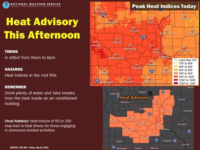
TWIN CITIES, MN — The National Weather Service has issued a heat advisory Friday for the Twin Cities metro area. Heat index values are expected to rise to nearly 100 degrees.
"Drink plenty of fluids, stay in an air-conditioned room, stay out of the sun, and check up on relatives and neighbors," the NWS warns.
"Young children and pets should never be left unattended in vehicles under any circumstances. Take extra precautions if you work or spend time outside. When possible reschedule strenuous activities to early morning or evening. Know the signs and symptoms of heat exhaustion and heat stroke. Wear lightweight and loose fitting clothing when possible. To reduce risk during outdoor work, the Occupational Safety and Health Administration recommends scheduling frequent rest breaks in shaded or air conditioned environments. Anyone overcome by heat should be moved to a cool and shaded location. Heat stroke is an emergency! Call 9 1 1."
Find out what's happening in Southwest Minneapolisfor free with the latest updates from Patch.
Showers and thunderstorms are set to arrive overnight Friday into Saturday.
Here's the full NWs forecast for the Twin Cities metro area:
Find out what's happening in Southwest Minneapolisfor free with the latest updates from Patch.
Friday: A 20 percent chance of showers and thunderstorms after 3pm. Mostly sunny and hot, with a high near 94. Heat index values as high as 99. South wind 10 to 15 mph.
Friday Night: Showers and thunderstorms likely, mainly between 1am and 3am. Mostly cloudy, with a low around 72. South wind 5 to 10 mph. Chance of precipitation is 60%. New rainfall amounts between a quarter and half of an inch possible.
Saturday: A 30 percent chance of showers and thunderstorms before 7am. Widespread haze after 1pm. Sunny and hot, with a high near 93. Northwest wind 5 to 15 mph.
Saturday Night: Clear, with a low around 63. Northwest wind 5 to 10 mph becoming light west northwest in the evening.
Sunday: Sunny and hot, with a high near 93. Light west northwest wind becoming west 5 to 10 mph in the afternoon.
Sunday Night: A 20 percent chance of showers and thunderstorms after 1am. Mostly clear, with a low around 65. West wind around 5 mph becoming calm in the evening.
Monday: A 20 percent chance of showers and thunderstorms after 1pm. Sunny, with a high near 92. Calm wind becoming southwest around 5 mph in the morning.
Monday Night: A 20 percent chance of showers and thunderstorms. Mostly clear, with a low around 68. South wind around 5 mph.
Tuesday: Sunny and hot, with a high near 94. South southwest wind around 5 mph.
Tuesday Night: A 20 percent chance of showers and thunderstorms after 1am. Mostly clear, with a low around 69. South southeast wind around 5 mph becoming calm in the evening.
Wednesday: A 20 percent chance of showers and thunderstorms. Mostly sunny and hot, with a high near 95. South wind 5 to 10 mph becoming west in the afternoon.
Wednesday Night: A 30 percent chance of showers and thunderstorms. Partly cloudy, with a low around 68. West wind around 5 mph becoming calm after midnight.
Thursday: A 20 percent chance of showers and thunderstorms. Mostly sunny, with a high near 89. Calm wind becoming north northeast around 5 mph in the morning.
Get more local news delivered straight to your inbox. Sign up for free Patch newsletters and alerts.


