Weather
MN Weather: 2022 Easter Weekend Forecast
Here's the weather you can expect for Easter weekend and beyond in Minnesota.

TWIN CITIES, MN — Thursday and Friday could feature storms in the Twin Cities metro area.
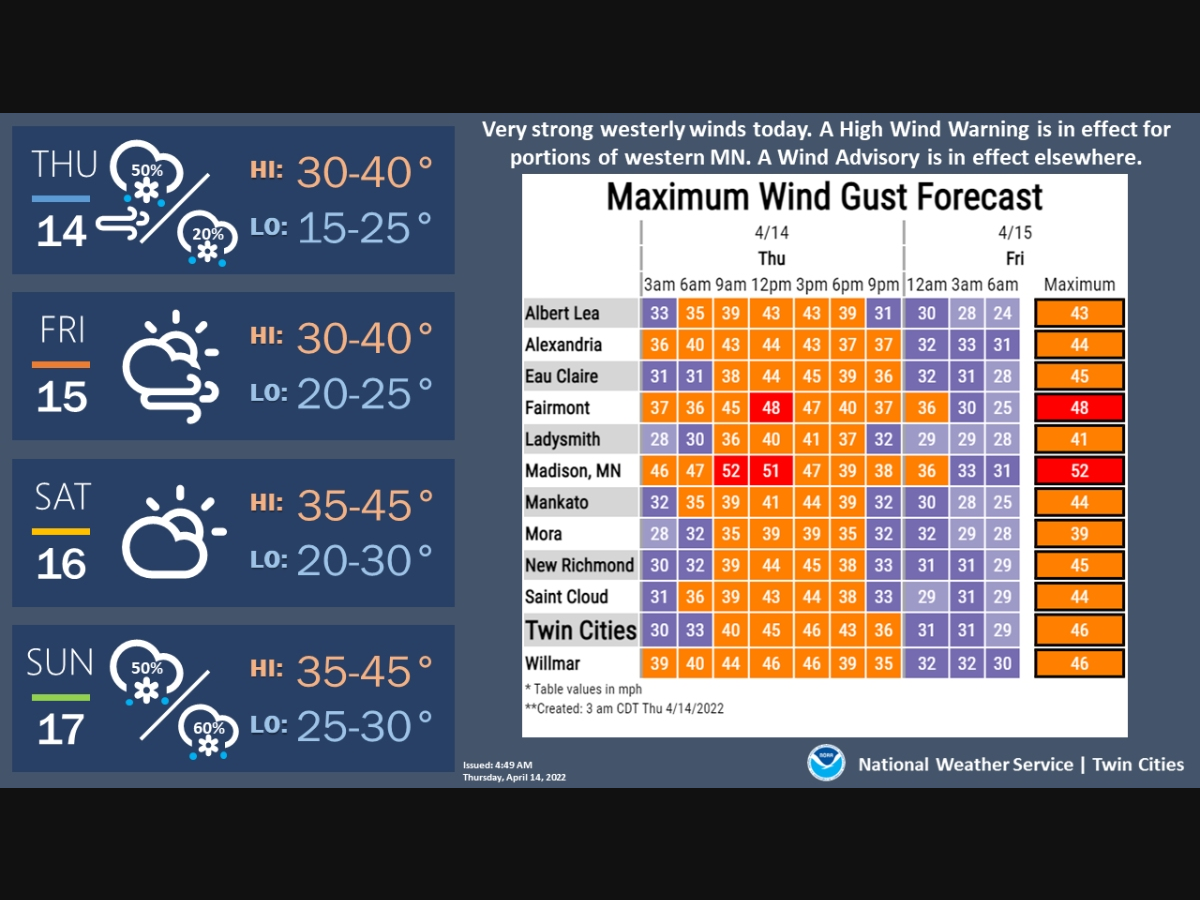
"Strong westerly winds expected today with gusts up to 60 mph possible in western MN," the National Weather Service said. "Gusts of 45-55 mph possible elsewhere. Scattered snow showers also possible today with rain mixing in during the afternoon. Some snow showers could be intense reducing visibility."
Saturday will be sunny with a high of 41, but Easter Sunday could feature a chance for snow in the metro.
Find out what's happening in Southwest Minneapolisfor free with the latest updates from Patch.
Looking ahead, the NWS says that "There's a chance for above normal temperatures to return across the Midwest for the end of April."

Here’s the full NWS forecast from the Minneapolis-St. Paul International Airport:
Find out what's happening in Southwest Minneapolisfor free with the latest updates from Patch.
Thursday: Scattered snow showers before 1pm, then rain and snow showers likely. Cloudy, with a high near 38. Windy, with a west southwest wind 25 to 30 mph, with gusts as high as 45 mph. Chance of precipitation is 60%. Total daytime snow accumulation of less than a half inch possible.
Thursday Night: Scattered rain and snow showers before 11pm, then a slight chance of snow showers between 11pm and 1am. Mostly cloudy, with a low around 25. Breezy, with a west wind 20 to 25 mph, with gusts as high as 45 mph. Chance of precipitation is 30%.
Friday: Partly sunny, with a high near 37. Breezy, with a west wind 15 to 20 mph, with gusts as high as 30 mph.
Friday Night: Partly cloudy, with a low around 24. West northwest wind 10 to 15 mph.
Saturday: Mostly sunny, with a high near 41. Northwest wind 10 to 15 mph.
Saturday Night: Mostly clear, with a low around 26. Northwest wind 5 to 10 mph becoming east after midnight.
Sunday: A chance of snow after 8am, mixing with rain afternoon. Partly sunny, with a high near 42. East southeast wind 5 to 10 mph. Chance of precipitation is 50%.
Sunday Night: Rain likely before 10pm, then rain and snow likely. Mostly cloudy, with a low around 31. South wind around 10 mph becoming west southwest after midnight. Chance of precipitation is 60%.
Monday: A chance of rain and snow, mainly before noon. Partly sunny, with a high near 42. Breezy, with a west northwest wind 10 to 20 mph, with gusts as high as 30 mph. Chance of precipitation is 40%.
Monday Night: Mostly cloudy, then gradually becoming clear, with a low around 26. Northwest wind 5 to 15 mph, with gusts as high as 25 mph.
Tuesday: Mostly sunny, with a high near 48. North wind 5 to 10 mph becoming southeast in the morning.
Tuesday Night: A 30 percent chance of rain. Mostly cloudy, with a low around 38. Southeast wind around 15 mph.
Wednesday: A 50 percent chance of rain. Mostly cloudy, with a high near 55. Southeast wind around 15 mph becoming south southwest in the afternoon.
Get more local news delivered straight to your inbox. Sign up for free Patch newsletters and alerts.


