Weather
MN Weather: Foot Of Snow Possible For Twin Cities Metro
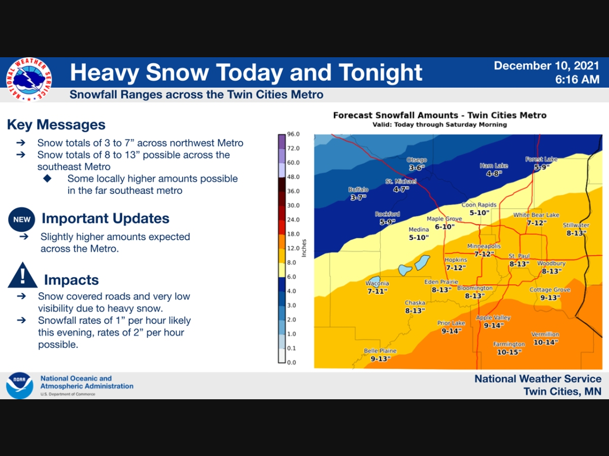
A massive snowstorm is still on track to hit the Minneapolis-St. Paul metro area Friday. Here's what you need to know.

TWIN CITIES, MN — A massive snowstorm is still on track to hit the Minneapolis-St. Paul metro area Friday. Hennepin, Ramsey, Washington, Carver, Scott, Dakota County are under a winter storm warning. The warning will expire at 6 a.m. Saturday.
Up to 5 inches of snow could fall during the afternoon, with another 9 inches possible Friday night.
"A band of snow will develop across southern Minnesota and lift into the southern Metro this morning," the National Weather Service said.
Find out what's happening in Southwest Minneapolisfor free with the latest updates from Patch.
"The snow will become more widespread this afternoon and evening. Areas under the heaviest band in the far southern/eastern Metro will likely see over a foot of snow. Be prepared for snow covered roads, very low visibility, and travel impacts."
Here is the 7am radar update for the approaching Winter Storm. A narrow band of snow has developed across South Dakota & SW Minnesota. It will gradually lift north with snow beginning after 10am in the south metro and around noon in the north metro. #mnwx #wiwx pic.twitter.com/7KXgpkIQDQ
— NWS Twin Cities (@NWSTwinCities) December 10, 2021
This is a forecast map of visibility, but it gives us a good idea of when the snow will be heaviest tomorrow. The dark red, & especially purple, colors indicate when the greatest travel impacts are expected. #mnwx #wiwx pic.twitter.com/f91iDUNxvP
— NWS Twin Cities (@NWSTwinCities) December 10, 2021
Here's the weekend NWS forecast for the Twin Cities metro area:
Find out what's happening in Southwest Minneapolisfor free with the latest updates from Patch.
Friday: Snow, mainly after noon. High near 30. Northeast wind 5 to 15 mph. Chance of precipitation is 100%. Total daytime snow accumulation of 3 to 5 inches possible.
Friday Night: Snow, mainly before 2am. Some thunder is also possible. Low around 22. North northeast wind around 15 mph becoming northwest after midnight. Winds could gust as high as 25 mph. Chance of precipitation is 100%. New snow accumulation of 5 to 9 inches possible.
Saturday: Mostly cloudy through mid morning, then gradual clearing, with a high near 28. West northwest wind around 10 mph becoming southwest in the afternoon.
Saturday Night: Mostly clear, with a low around 20. South southwest wind around 10 mph.
Sunday: Mostly sunny, with a high near 35. South southwest wind 10 to 15 mph.
Sunday Night: Mostly clear, with a low around 20. South southwest wind 5 to 10 mph.
Weather officials say that if you must travel, keep an extra flashlight, food, and water in your vehicle in case of an emergency.
"Travel could be very difficult to impossible," the National Weather Service said. "The hazardous conditions could impact the evening commute."
Find the latest road conditions by calling 511.
Get more local news delivered straight to your inbox. Sign up for free Patch newsletters and alerts.


