Weather
MN Weather: Heat Wave Arrives Next Week
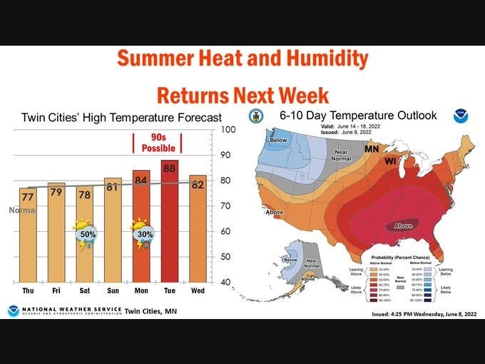
"Those that have been clamoring for some more heat and humidity this summer, the forecast next week is for you," the NWS said.

TWIN CITIES, MN — Residents of the Twin Cities metro area can expect a heat wave to arrive in the coming days.
"Those that have been clamoring for some more heat and humidity this summer, the forecast next week is for you," the National Weather Service said.
"For the rest of us, we'll enjoy this pleasant and dry weather through Friday."
Find out what's happening in Southwest Minneapolisfor free with the latest updates from Patch.
Here’s the full NWS forecast from the Minneapolis-St. Paul International Airport:
Thursday: Increasing clouds, with a high near 79. West wind 5 to 10 mph.
Find out what's happening in Southwest Minneapolisfor free with the latest updates from Patch.
Thursday Night: Partly cloudy, with a low around 59. West northwest wind 5 to 10 mph becoming south southeast in the evening.
Friday: A 20 percent chance of showers and thunderstorms after 1pm. Mostly sunny, with a high near 79. Calm wind becoming north northwest around 5 mph in the afternoon.
Friday Night: A 20 percent chance of showers and thunderstorms after 1am. Mostly cloudy, with a low around 62. West wind around 5 mph becoming south after midnight.
Saturday: Showers likely and possibly a thunderstorm. Mostly cloudy, with a high near 81. South southwest wind 5 to 10 mph. Chance of precipitation is 60%. New rainfall amounts between a tenth and quarter of an inch, except higher amounts possible in thunderstorms.
Saturday Night: A 30 percent chance of showers and thunderstorms before 1am. Partly cloudy, with a low around 61. North northeast wind 5 to 10 mph becoming east after midnight.
Sunday: A 20 percent chance of showers after 1pm. Mostly sunny, with a high near 82. East northeast wind 5 to 10 mph.
Sunday Night: A 30 percent chance of showers, mainly after 1am. Partly cloudy, with a low around 65. East southeast wind around 10 mph.
Monday: A chance of showers, with thunderstorms also possible after 1pm. Partly sunny, with a high near 83. Breezy, with an east southeast wind 10 to 20 mph, with gusts as high as 30 mph. Chance of precipitation is 30%.
Monday Night: A 20 percent chance of showers and thunderstorms. Partly cloudy, with a low around 70. Breezy, with a southeast wind 15 to 20 mph.
Tuesday: A 20 percent chance of showers. Mostly sunny, with a high near 88. Southeast wind around 15 mph becoming south southwest in the afternoon. Winds could gust as high as 30 mph.
Tuesday Night: A 20 percent chance of showers and thunderstorms. Partly cloudy, with a low around 66. West wind 10 to 15 mph.
Wednesday: A 30 percent chance of showers and thunderstorms. Mostly sunny, with a high near 83. West southwest wind 5 to 15 mph, with gusts as high as 25 mph.
Get more local news delivered straight to your inbox. Sign up for free Patch newsletters and alerts.


