Weather
MN Weather Update: Snow Showers 'Likely'
Here's what to expect from the storms forecasted to hit the Twin Cities metro area this week.

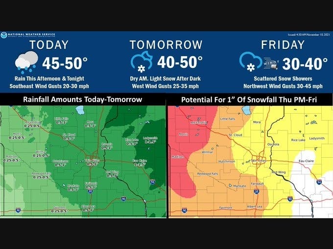
TWIN CITIES, MN — Snow is "likely" to fall on Thursday night into Friday in the Twin Cities metro, according to the latest forecast from the National Weather Service forecast.
The snow will come after strong winds and rains Wednesday and Thursday.
"Thursday will start out dry, with light snow developing after dark and continuing into Friday. Wind gusts in excess of 40 mph are likely Friday, which could lead to some travel impacts in any snow showers."
Find out what's happening in Southwest Minneapolisfor free with the latest updates from Patch.
Widespread rain will spread from west to east this afternoon with gusty southeast winds developing through the day. Thursday will start out dry, with light snow developing after dark and continuing into Friday. Wind gusts in excess of 40 mph are likely Friday.#mnwx #wiwx pic.twitter.com/4phmbi2rRA
— NWS Twin Cities (@NWSTwinCities) November 10, 2021
Here's the full NWS forecast for the Twin Cities metro area:Red=High, Orange=Medium, Yellow=Low
— NWS Twin Cities (@NWSTwinCities) November" class="redactor-linkify-object">https://twitter.com/NWSTwinCit... 10, 2021
Wednesday: Rain, mainly after 4pm. High near 52. East southeast wind 5 to 15 mph, with gusts as high as 25 mph. Chance of precipitation is 80%. New precipitation amounts between a tenth and quarter of an inch possible.
Wednesday Night: Rain, mainly before 5am. Low around 40. Southeast wind 5 to 15 mph becoming west northwest after midnight. Winds could gust as high as 30 mph. Chance of precipitation is 100%. New precipitation amounts between a half and three quarters of an inch possible.
Veterans Day: A chance of rain before 8am, then isolated showers after 3pm. Cloudy, with a steady temperature around 41. Breezy, with a west wind 15 to 20 mph, with gusts as high as 30 mph. Chance of precipitation is 30%.
Thursday Night: Scattered rain and snow showers before 9pm, then snow showers likely. Cloudy, with a low around 32. West southwest wind 10 to 15 mph. Chance of precipitation is 70%. New snow accumulation of less than one inch possible.
Friday: Snow showers likely before noon, then scattered rain and snow showers. Mostly cloudy, with a high near 37. Breezy, with a north northwest wind 10 to 20 mph, with gusts as high as 30 mph. Chance of precipitation is 60%. New snow accumulation of less than one inch possible.
Friday Night: Mostly cloudy, with a low around 29. North northwest wind 10 to 15 mph.
Saturday: Mostly cloudy, with a high near 36. Northwest wind 5 to 10 mph becoming west southwest in the afternoon.
Saturday Night: A 30 percent chance of snow, mainly before midnight. Mostly cloudy, with a low around 28. West southwest wind around 5 mph becoming east after midnight.
Sunday: Mostly cloudy, with a high near 35. North northwest wind 5 to 10 mph.
Sunday Night: Mostly cloudy, with a low around 23. Northwest wind around 5 mph becoming calm after midnight.
Monday: Partly sunny, with a high near 35. Calm wind becoming south southwest around 5 mph in the morning.
Monday Night: Mostly cloudy, with a low around 27. South wind around 5 mph.
Tuesday: Partly sunny, with a high near 43. South wind 5 to 10 mph.
Find out what's happening in Southwest Minneapolisfor free with the latest updates from Patch.
Get more local news delivered straight to your inbox. Sign up for free Patch newsletters and alerts.


