Weather
More Severe Storms Possible Wednesday: MN Weather
Residents of the Twin Cities should prepare for the possibility of more severe weather on Wednesday.

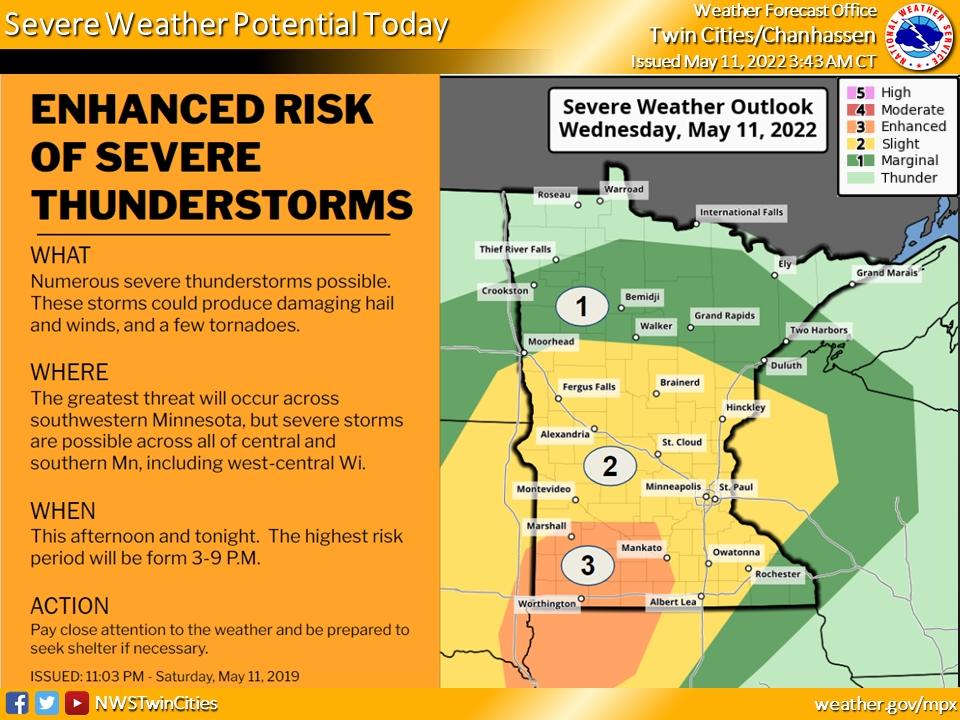
TWIN CITIES, MN — Residents of the Twin Cities should prepare for the possibility of more severe weather on Wednesday.
"A few thunderstorms are possible this morning as a frontal boundary moves northward from Iowa," the National Weather Service said.
"Later this afternoon, a complex of thunderstorms are expected to develop across eastern Nebraska, and move north-northeast toward southwest Minnesota. These storms are expected to intensify as they move into Minnesota. Please be aware that severe weather is possible later today. Be prepared and monitor the latest forecast and possible warnings."
Find out what's happening in Southwest Minneapolisfor free with the latest updates from Patch.
Here’s the full NWS forecast from the Minneapolis-St. Paul International Airport:
Wednesday: A 30 percent chance of showers and thunderstorms, mainly after 5pm. Some of the storms could be severe. Partly sunny, with a high near 82. Northeast wind 10 to 15 mph becoming east southeast in the afternoon.
Find out what's happening in Southwest Minneapolisfor free with the latest updates from Patch.
Wednesday Night: Showers and thunderstorms likely before 10pm, then showers and possibly a thunderstorm between 10pm and 4am, then a chance of showers and thunderstorms after 4am. Some of the storms could be severe and produce heavy rainfall. Low around 68. Southeast wind 10 to 15 mph. Chance of precipitation is 80%. New rainfall amounts between 1 and 2 inches possible.
Thursday: A 30 percent chance of showers and thunderstorms, mainly before 7am. Mostly sunny, with a high near 91. Breezy, with an east wind 10 to 20 mph becoming south in the afternoon. Winds could gust as high as 30 mph.
Thursday Night: A chance of showers and thunderstorms. Partly cloudy, with a low around 66. South southwest wind 10 to 15 mph, with gusts as high as 30 mph. Chance of precipitation is 50%. New rainfall amounts between a tenth and quarter of an inch, except higher amounts possible in thunderstorms.
Friday: Mostly sunny, with a high near 78. West southwest wind around 10 mph.
Friday Night: Mostly clear, with a low around 57. West wind around 5 mph becoming south southeast after midnight.
Saturday: A 30 percent chance of showers after 1pm. Mostly sunny, with a high near 76. South wind 5 to 15 mph becoming west northwest in the afternoon. Winds could gust as high as 25 mph.
Saturday Night: Mostly clear, with a low around 53. West northwest wind 5 to 15 mph.
Sunday: A 20 percent chance of showers and thunderstorms after 1pm. Mostly sunny, with a high near 72. West wind 10 to 15 mph.
Sunday Night: Mostly clear, with a low around 51. West northwest wind 10 to 15 mph.
Monday: Sunny, with a high near 69. Northwest wind 10 to 15 mph.
Monday Night: A 20 percent chance of showers. Mostly clear, with a low around 49. North wind 5 to 15 mph.
Tuesday: A 20 percent chance of showers. Mostly sunny, with a high near 66. North wind around 10 mph.
Get more local news delivered straight to your inbox. Sign up for free Patch newsletters and alerts.


