Weather
'Near Record Highs And Dangerous Heat' This Weekend: MN Weather
Hot weather will arrive this weekend in Minnesota and this time, it will stick around for a while, says to the National Weather Service.

TWIN CITIES, MN — Friday will be our last day with relatively mild weather in the Twin Cities for a while. Extreme heat will move into the region this weekend.
"A warm front will move back across the area Saturday and Saturday night," the National Weather Service said.
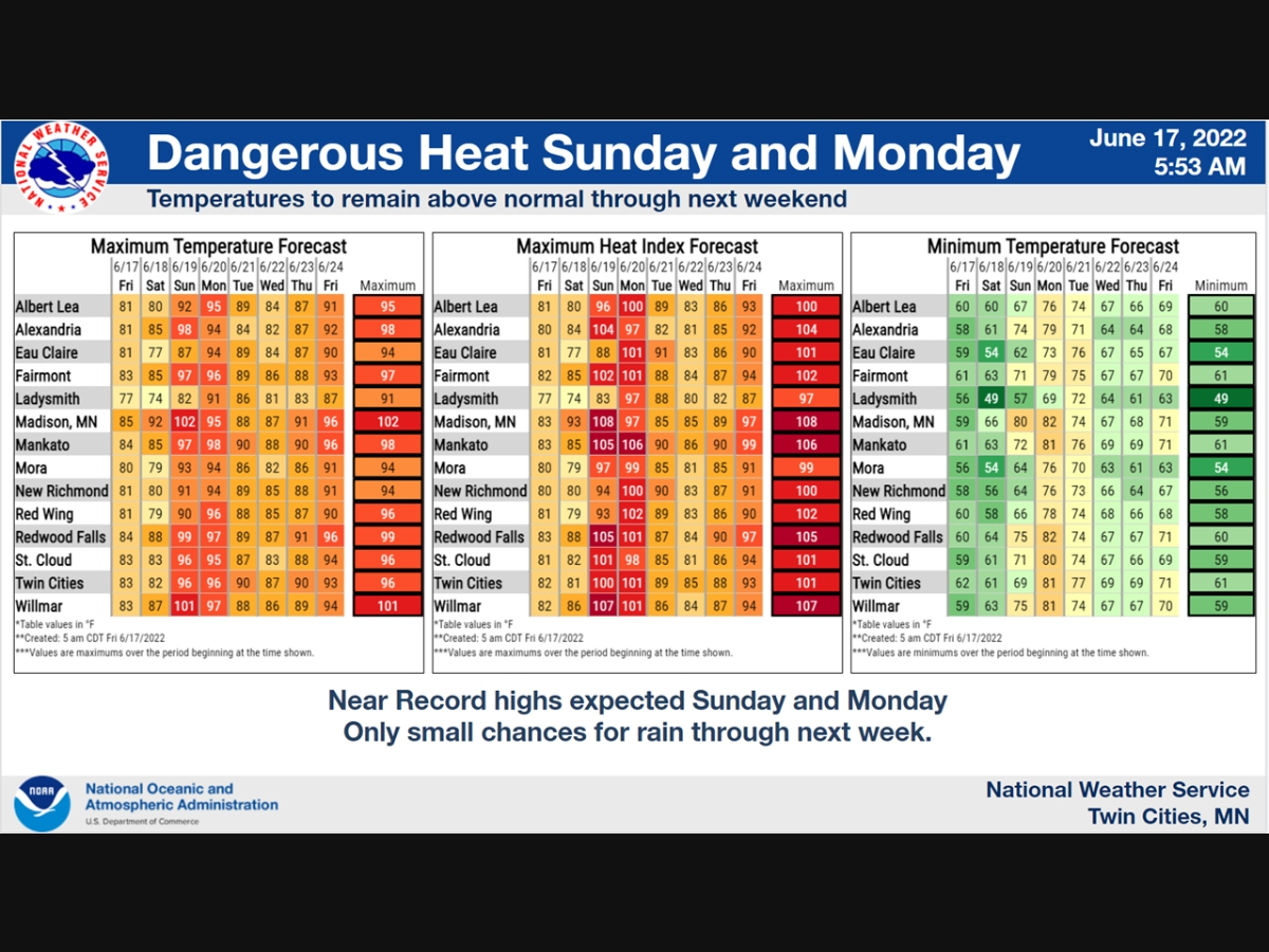
"In its wake will be near record highs and dangerous heat for Sunday and Monday. Though not as warm as Sunday and Monday, the rest of the week into next weekend will feature above normal temperatures. To go along with the heat, precipitation chances are pretty small over the next week, with the best chance at seeing some rain coming Monday afternoon into Monday night."
Find out what's happening in Southwest Minneapolisfor free with the latest updates from Patch.
Here's the full NWS forecast from the Minneapolis-St. Paul International Airport:
Friday: Sunny, with a high near 85. Northwest wind 5 to 10 mph.
Find out what's happening in Southwest Minneapolisfor free with the latest updates from Patch.
Friday Night: Clear, with a low around 60. North northeast wind 5 to 10 mph becoming east after midnight.
Saturday: A slight chance of showers and thunderstorms between 1pm and 2pm. Sunny, with a high near 83. Southeast wind 10 to 15 mph. Chance of precipitation is 20%.
Saturday Night: Mostly clear, with a low around 68. Breezy, with a southeast wind 15 to 20 mph.
Juneteenth: Sunny and hot, with a high near 94. Breezy, with a south wind 15 to 20 mph, with gusts as high as 30 mph.
Sunday Night: Mostly clear, with a low around 79. Breezy, with a south wind 10 to 20 mph, with gusts as high as 30 mph.
Monday: A 20 percent chance of showers and thunderstorms after 1pm. Sunny and hot, with a high near 98. South southwest wind 10 to 15 mph.
Monday Night: A 40 percent chance of showers and thunderstorms, mainly before 1am. Partly cloudy, with a low around 76. Southwest wind 10 to 15 mph.
Tuesday: Sunny, with a high near 92. West wind 10 to 15 mph, with gusts as high as 25 mph.
Tuesday Night: Mostly clear, with a low around 67. West northwest wind 5 to 15 mph.
Wednesday: Mostly sunny, with a high near 87. West wind 5 to 15 mph.
Wednesday Night: A 20 percent chance of showers and thunderstorms. Partly cloudy, with a low around 66. West wind 5 to 10 mph becoming south after midnight.
Thursday: Sunny, with a high near 90. Southwest wind 5 to 10 mph.
Get more local news delivered straight to your inbox. Sign up for free Patch newsletters and alerts.


