Weather
'Nearly All Of Minnesota' Now Under Wind Chill Advisory
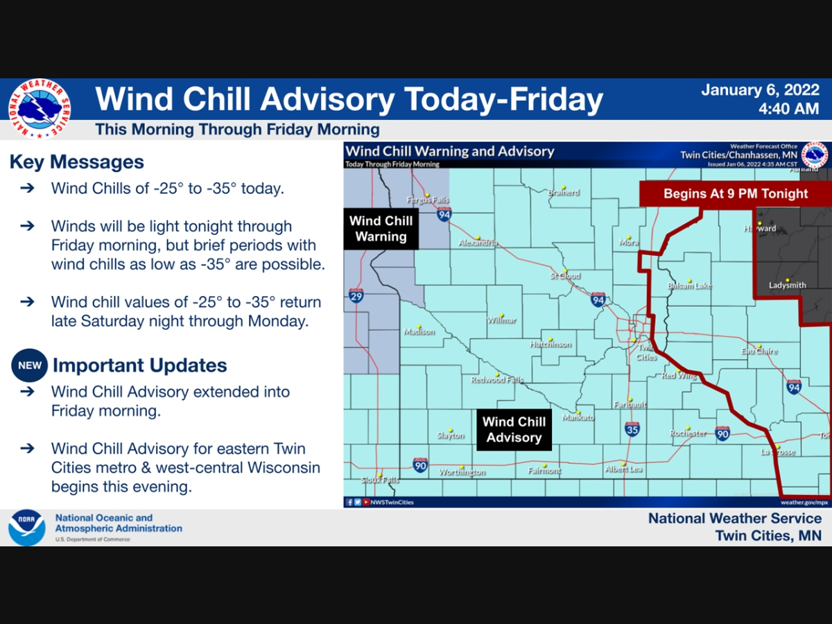
"The dangerously cold wind chills could cause frostbite on exposed skin in as little as 10 minutes," the NWS warned.

TWIN CITIES, MN — The National Weather Service has issued a wind chill advisory for "nearly all of Minnesota." The advisory will last through Friday at 10 a.m.
Residents should expect wind chills of -25 to -35. "The dangerously cold wind chills could cause frostbite on exposed skin in as little as 10 minutes," the NWS warned.
Light snow ends across west-central Wisconsin ends this morning. Very cold today, with wind chills of -25 to -35 expected through Friday morning. After a brief warm-up Saturday, Arctic air returns along with hazardous wind chills late Saturday night through Sunday.#mnwx #wiwx pic.twitter.com/WGyLeayZ2e
— NWS Twin Cities (@NWSTwinCities) January 6, 2022
After a brief warm-up Saturday, Arctic air will return Sunday.
Find out what's happening in Southwest Minneapolisfor free with the latest updates from Patch.
Here's the full NWS forecast for the Twin Cities metro area:
Thursday: A 20 percent chance of snow before 8am. Mostly cloudy and cold, with a high near -1. Wind chill values as low as -22. Northwest wind around 10 mph.
Find out what's happening in Southwest Minneapolisfor free with the latest updates from Patch.
Thursday Night: Partly cloudy, with a low around -16. Wind chill values as low as -26. West northwest wind around 5 mph.
Friday: Mostly sunny and cold, with a high near 4. Wind chill values as low as -26. West northwest wind 5 to 10 mph becoming southeast in the afternoon.
Friday Night: Mostly cloudy, with a temperature rising to around 13 by 5am. Wind chill values as low as -13. Breezy, with a south southeast wind 10 to 20 mph, with gusts as high as 30 mph.
Saturday: Mostly cloudy, with a high near 30. South wind 10 to 15 mph becoming west southwest in the afternoon.
Saturday Night: Patchy blowing snow between 9pm and 11pm. Partly cloudy, with a low around -3. Blustery, with a west northwest wind 10 to 20 mph, with gusts as high as 30 mph.
Sunday: Sunny and cold, with a high near 3. West northwest wind 10 to 15 mph.
Sunday Night: Partly cloudy, with a low around -11. West northwest wind 5 to 10 mph.
Monday: Sunny and cold, with a high near 3. West northwest wind 5 to 10 mph.
Monday Night: Mostly clear, with a low around -8. West wind around 5 mph becoming south southeast after midnight.
Tuesday: Mostly sunny, with a high near 23. South southwest wind 5 to 10 mph.
Tuesday Night: Partly cloudy, with a low around 9. West wind around 5 mph.
Wednesday: Mostly sunny, with a high near 26. West wind around 5 mph.
Get more local news delivered straight to your inbox. Sign up for free Patch newsletters and alerts.


