Weather
Plowable Snow Now Possible: MN Weather
Temperatures will fall into the 20s later this week in the Twin Cities metro area. Both rain and snow are likely.

TWIN CITIES, MN — The Twin Cities and the rest of Minnesota are sure to get a mix of rain and snow this weekend. But as temperatures fall in the updated forecasts, the chances for plowable snow are increasing.
"It’s still far too early to be precise about timing, coverage, and potential rain and snowfall totals," writes Minnesota Public Radio's Paul Huttner.
"But the odds of a plowable snow event for parts of Minnesota next week are growing with each forecast model run."
Find out what's happening in Southwest Minneapolisfor free with the latest updates from Patch.
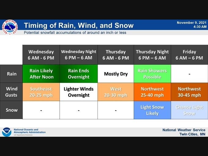
After a mild Tuesday, the rain will begin to fall in the metro Wednesday. Our best chance for snow that sticks is Saturday, when temperatures will fall to the low-20s.
"A large storm system will bring an extended stretch of active weather beginning Wednesday afternoon," notes the National Weather Service.
Find out what's happening in Southwest Minneapolisfor free with the latest updates from Patch.
"Widespread rain and gusty winds are expected Wednesday PM, with some light snow likely along with gusty winds late Thursday night into Friday."
Here's the full NWS forecast for the Twin Cities metro area:
Tuesday: Mostly cloudy through mid morning, then gradual clearing, with a high near 53. Calm wind becoming west around 5 mph.
Tuesday Night: Increasing clouds, with a low around 34. Calm wind becoming southeast around 5 mph after midnight.
Wednesday: Rain likely after noon. Mostly cloudy, with a high near 51. Southeast wind 5 to 15 mph. Chance of precipitation is 70%. New precipitation amounts between a tenth and quarter of an inch possible.
Wednesday Night: Rain, mainly before midnight. Low around 39. Southeast wind 5 to 10 mph becoming west northwest in the evening. Chance of precipitation is 90%. New precipitation amounts between a half and three quarters of an inch possible.
Veterans Day: A 40 percent chance of rain. Partly sunny, with a high near 46. West wind 10 to 15 mph.
Thursday Night: A chance of rain and snow before 3am, then a chance of snow. Mostly cloudy, with a low around 31. West wind 10 to 15 mph. Chance of precipitation is 50%. New snow accumulation of less than a half inch possible.
Friday: A chance of snow before noon, then a slight chance of rain and snow. Mostly cloudy, with a high near 37. Northwest wind around 15 mph. Chance of precipitation is 30%.
Friday Night: Mostly cloudy, with a low around 28. Northwest wind 10 to 15 mph.
Saturday: A slight chance of rain and snow after noon. Partly sunny, with a high near 37. Northwest wind 5 to 10 mph. Chance of precipitation is 20%.
Saturday Night: A 40 percent chance of snow. Mostly cloudy, with a low around 28. West wind around 5 mph becoming south southwest after midnight.
Sunday: A 20 percent chance of snow. Mostly cloudy, with a high near 36. Northwest wind 5 to 10 mph.
Sunday Night: Mostly cloudy, with a low around 23. Northwest wind 5 to 10 mph.
Monday: Partly sunny, with a high near 35. Northwest wind 5 to 10 mph.
Get more local news delivered straight to your inbox. Sign up for free Patch newsletters and alerts.


