Crime & Safety
Possible Record Warmth On Tap For Twin Cities This Weekend: See Forecast
Temperatures are expected to rise to 20-30 degrees above normal for mid-February, the National Weather Service wrote.

"Fool's Spring" is arriving in the Twin Cities in full force this weekend as temperatures are expected to reach possible record-high levels, according to the latest forecasts. Still, winter isn't over, some forecasters warn, and neither are the season's challenges.
Temperatures are on an appreciable warming trend through the weekend and are expected to rise to 20-30 degrees above normal for mid-February, the National Weather Service wrote.
Friday is expected to be warmer than Thursday with sunshine returning and highs pushing into the 40s and low 50s, according to forecasts.
Find out what's happening in Southwest Minneapolisfor free with the latest updates from Patch.
Saturday will be the warmest day in the metro, with temperatures possibly reaching the low 50s and record highs within reach. The current high on record is 50 degrees, set in 1882, according to Minneapolis Star Tribune forecaster Paul Douglas.
Meanwhile, much of southern Minnesota will see highs in the mid- to upper 50s, with some spots nearing 60 degrees.
Find out what's happening in Southwest Minneapolisfor free with the latest updates from Patch.
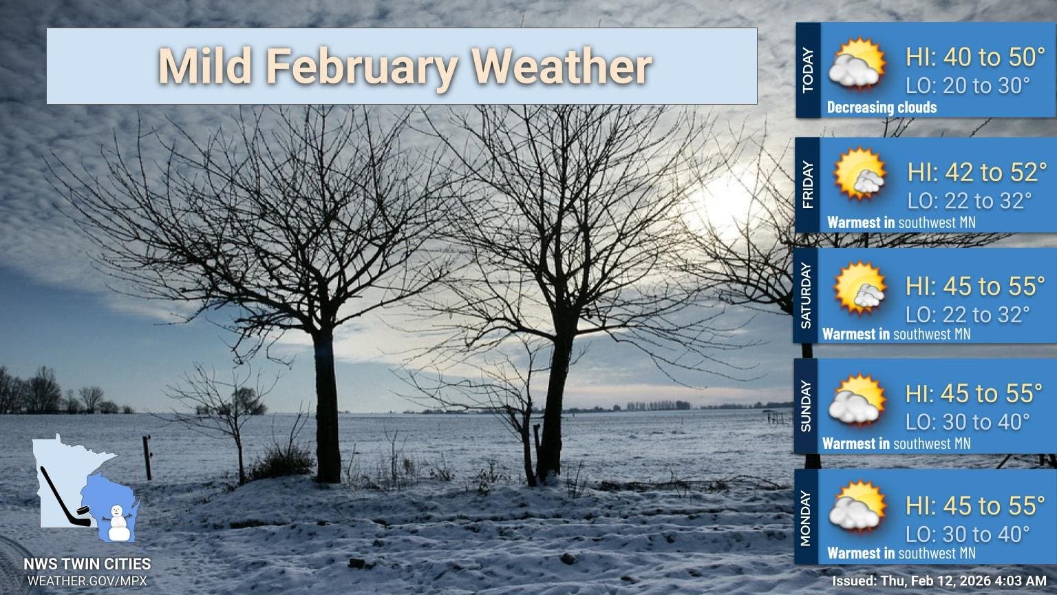
Sunday and Monday are also expected to see unseasonably warm temperatures, with highs hovering around 50 degrees.
Other than an increase in cloud cover tonight through Thursday morning, mostly clear skies will prevail with no precipitation expected.
While the warm temperatures will be a welcome respite for most winter-weary Minnesotans, overnight lows could still dip below freezing, causing water to refreeze and black ice to form.
An intense freeze-thaw cycle means a proliferation of potholes, Douglas wrote for the Star Tribune.
"If this is followed by a typical March cold snap, trees can suffer internal damage or lose their flower buds for the entire year," Douglas wrote, adding, "Rapid freeze-thaw cycles can push perennials and bulbs out of the soil, exposing their roots to dry, cold air, which often kills them."
Here's a look at the detailed forecast for the Twin Cities metro:
Thursday: Sunny, with a high near 44. South southeast wind around 5 mph.
Thursday Night: Partly cloudy, with a low around 28. Southeast wind around 5 mph becoming southwest after midnight.
Friday: Mostly sunny, with a high near 43. Southwest wind around 5 mph becoming calm in the afternoon.
Friday Night: Partly cloudy, with a low around 29. Calm wind becoming south southeast around 5 mph after midnight.
Saturday: Sunny, with a high near 50. South southeast wind around 5 mph becoming west in the afternoon.
Saturday Night: Partly cloudy, with a low around 30. West wind around 5 mph.
Sunday: Mostly sunny, with a high near 48. West wind around 5 mph becoming south in the afternoon.
Sunday Night: Mostly cloudy, with a low around 37. South southeast wind 5 to 10 mph.
Monday: Mostly cloudy, then gradually becoming sunny, with a high near 53. South wind 5 to 10 mph becoming east northeast in the afternoon.
Monday Night: Mostly clear, with a low around 36. East wind around 10 mph.
Tuesday: A 30 percent chance of rain. Partly sunny, with a high near 49. East wind 10 to 15 mph.
Get more local news delivered straight to your inbox. Sign up for free Patch newsletters and alerts.


