Weather
'Powerful Winter Storm' On Track For Tuesday: MN Weather Forecast
An incoming storm will bring rain and/or snow to your home this week, depending on where you live in Minnesota.

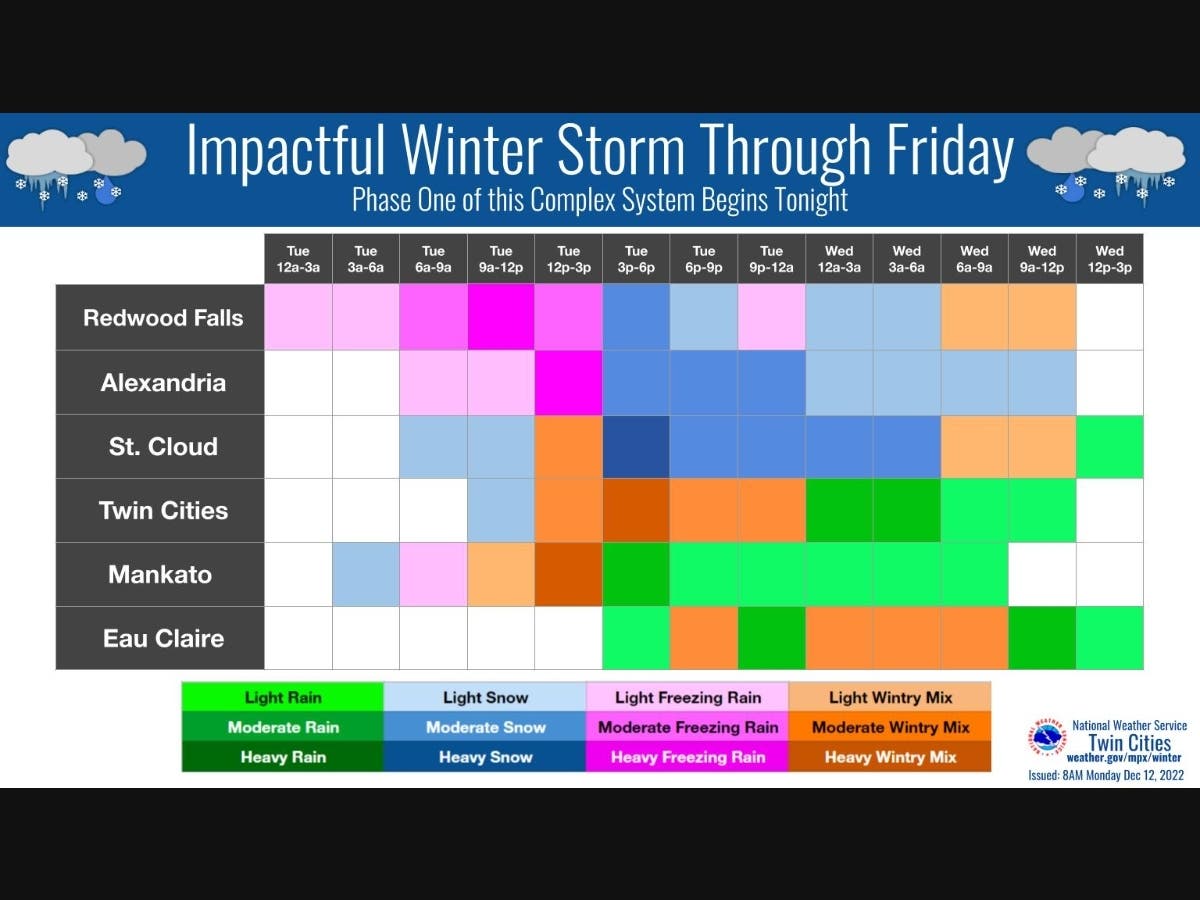
TWIN CITIES, MN — The National Weather Service says a "powerful winter storm" is still on track to make an impact in the Twin Cities and across central Minnesota this week.
"Freezing rain and snow will begin late tonight through early Wednesday," the NWS said.
"Freezing rain and wintry mix is likely across southern and western Minnesota and western Wisconsin, with mainly snow for central Minnesota and northwestern Wisconsin."
Find out what's happening in Southwest Minneapolisfor free with the latest updates from Patch.
Wind gusts are expected to reach up to 40 mph on Tuesday.
Here's the full NWS forecast from the Minneapolis-St. Paul Airport:
Find out what's happening in Southwest Minneapolisfor free with the latest updates from Patch.
Tuesday: Rain and snow, possibly mixed with sleet before 4pm, then rain, possibly mixed with sleet. High near 36. Breezy, with an east southeast wind 15 to 20 mph, with gusts as high as 40 mph. Chance of precipitation is 100%. New snow and sleet accumulation of less than a half inch possible.
Tuesday Night: Rain and snow before 2am, then rain between 2am and 5am, then rain and snow after 5am. Low around 34. Breezy, with an east southeast wind 15 to 20 mph, with gusts as high as 40 mph. Chance of precipitation is 100%. New snow accumulation of less than one inch possible.
Wednesday: Rain and snow likely, becoming all rain after 8am. Cloudy, with a high near 39. East southeast wind 10 to 15 mph. Chance of precipitation is 60%. New snow accumulation of less than a half inch possible.
Wednesday Night: A chance of rain before 11pm, then a chance of rain and snow between 11pm and 2am, then a chance of snow after 2am. Mostly cloudy, with a low around 32. East wind 5 to 10 mph. Chance of precipitation is 50%. New snow accumulation of less than a half inch possible.
Thursday: Snow likely. Mostly cloudy, with a high near 35. East northeast wind around 10 mph becoming north in the afternoon. Chance of precipitation is 70%.
Thursday Night: Snow likely. Mostly cloudy, with a low around 25. Northwest wind around 10 mph. Chance of precipitation is 70%.
Friday: Snow likely, mainly before noon. Mostly cloudy, with a high near 28. West northwest wind around 15 mph. Chance of precipitation is 70%.
Friday Night: A 40 percent chance of snow, mainly before midnight. Mostly cloudy, with a low around 14. West northwest wind 10 to 15 mph.
Saturday: Mostly cloudy, with a high near 20. West northwest wind 10 to 15 mph.
Saturday Night: Mostly cloudy, with a low around 7. West northwest wind around 10 mph.
Sunday: Partly sunny, with a high near 15. West wind around 10 mph.
Get more local news delivered straight to your inbox. Sign up for free Patch newsletters and alerts.


