Weather
Snow Possible In Twin Cities This Week: MN Weather
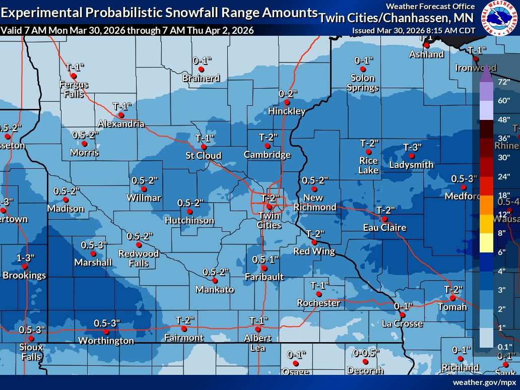
A midweek system could bring 1 to 2 inches of snow and slick travel conditions after a brief warmup.

MINNEAPOLIS, MN — A midweek storm system could bring accumulating snow to Minnesota just days after temperatures climb into the 70s, setting up a sharp return to winter conditions across the Twin Cities.
Forecasters say precipitation will begin as rain or a rain-snow mix Wednesday before transitioning to mainly snow Wednesday night, when the best chance for accumulation is expected.
Early projections indicate 1 to 2 inches of snow are possible in parts of the metro, though totals could shift depending on how quickly temperatures drop.
Find out what's happening in Southwest Minneapolisfor free with the latest updates from Patch.
The system is expected to linger into Thursday, bringing continued snow and a wintry mix that could create slippery roads and difficult travel conditions, especially during the morning commute.
Temperatures are forecast to remain near or below freezing, allowing snow to stick on roads, sidewalks and untreated surfaces.
Find out what's happening in Southwest Minneapolisfor free with the latest updates from Patch.
The setup is being driven by a strong cold front moving into Minnesota, replacing Monday’s springlike warmth with much colder air. That temperature swing will allow rain to change over to snow in a relatively short window Wednesday evening.
Even outside of the accumulating snow, the broader pattern points to an extended stretch of below-average temperatures, with highs stuck in the 30s and 40s through the end of the week.
Drivers are encouraged to monitor updated forecasts as the system approaches, as small changes in temperature could significantly impact snowfall totals and road conditions.
Here's the full NWS forecast from the Minneapolis-St. Paul Airport:
Today: Mostly sunny, with a high near 72. North wind 5 to 10 mph becoming east in the afternoon.
Tonight: A 10 percent chance of showers and thunderstorms after 5am. Partly cloudy, with a low around 39. North northeast wind around 10 mph.
Tuesday: A chance of showers and thunderstorms before 7am, then a slight chance of showers between 7am and 8am. Mostly cloudy, with a high near 49. Breezy, with a north northwest wind 15 to 20 mph, with gusts as high as 25 mph. Chance of precipitation is 30%.
Tuesday Night: Mostly cloudy, with a low around 30. North northwest wind 10 to 15 mph.
Wednesday: A chance of snow showers after 1pm, mixing with rain after 5pm. Mostly cloudy, with a high near 43. East wind around 10 mph. Chance of precipitation is 30%.
Wednesday Night: Snow showers likely, possibly mixed with rain, becoming all snow after 7pm. Mostly cloudy, with a low around 30. East wind around 15 mph. Chance of precipitation is 70%. New snow accumulation of 1 to 2 inches possible.
Thursday: Snow showers before 9am, then rain and snow showers. High near 38. East northeast wind around 15 mph. Chance of precipitation is 80%. New precipitation amounts between a tenth and quarter of an inch possible.
Thursday Night: Rain, possibly mixed with snow showers, mainly before 7pm. Low around 29. North northeast wind 5 to 10 mph. Chance of precipitation is 80%.
Friday: A 40 percent chance of showers after 1pm. Mostly cloudy, with a high near 44. East northeast wind 5 to 10 mph.
Friday Night: Rain showers likely before midnight, then rain and snow showers likely. Some thunder is also possible. Mostly cloudy, with a low around 35. East northeast wind around 10 mph. Chance of precipitation is 70%.
Saturday: Rain and snow showers likely. Mostly cloudy, with a high near 44. Northeast wind 10 to 15 mph becoming northwest in the afternoon. Chance of precipitation is 60%.
Saturday Night: A chance of rain and snow showers. Mostly cloudy, with a low around 30. Northwest wind 10 to 15 mph. Chance of precipitation is 30%.
Sunday: Mostly sunny, with a high near 45. Northwest wind 10 to 15 mph.
Get more local news delivered straight to your inbox. Sign up for free Patch newsletters and alerts.


