Weather
Twin Cities Could See 4 Inches Of Snow From 'Alberta Clipper'
An "Alberta Clipper" is set to dump snow across Minnesota Friday.

TWIN CITIES, MN — An "Alberta Clipper" is set to dump snow across Minnesota Friday.
The storm began in Alberta, Canada, and has since moved southeast. The storm is caused by a low-pressure system and usually brings cold and snow along with it, according to the National Weather Service.
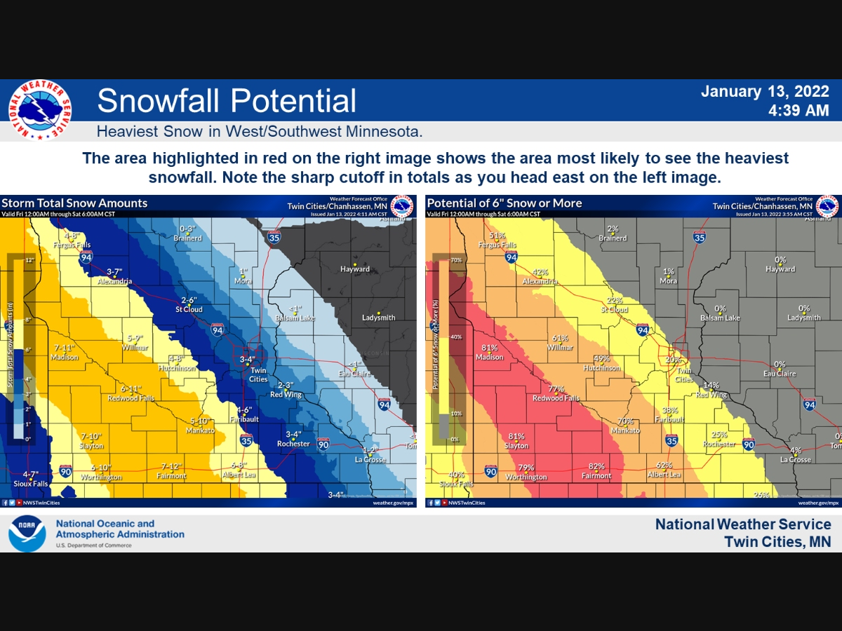
Up to 4 inches of snow could fall in the Twin Cities metro area Friday.
Find out what's happening in Southwest Minneapolisfor free with the latest updates from Patch.
A Winter Storm Warning has been issued for west to southwest MN where there is high confidence in seeing 6 or more inches of snow on Friday. The Winter Storm Watch was expanded east again due a slight eastwards trend overnight. #mnwx #wiwx pic.twitter.com/dhlRSpVyha
— NWS Twin Cities (@NWSTwinCities) January 13, 2022
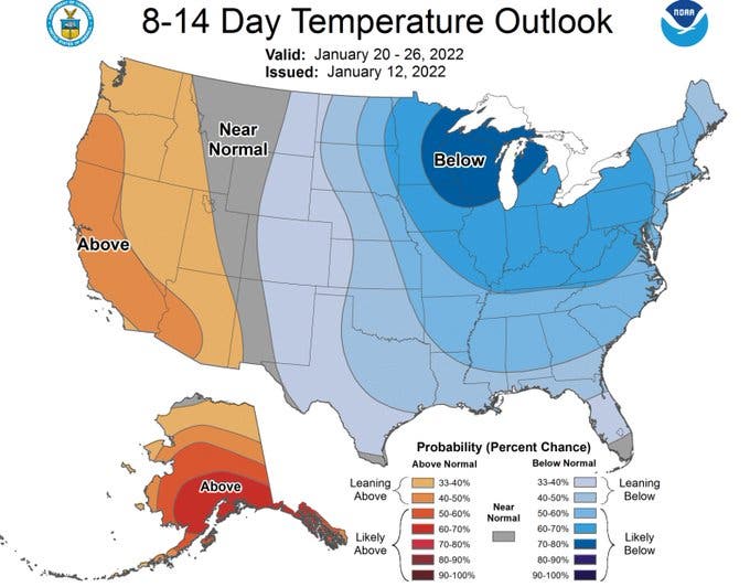
Following the storm, we can expect below-normal temperatures for the remainder of January.
Here's the full NWS forecast for the Twin Cities metro area:
Find out what's happening in Southwest Minneapolisfor free with the latest updates from Patch.
Thursday: Mostly cloudy, with a high near 30. North northwest wind 5 to 10 mph.
Thursday Night: A 20 percent chance of snow after 5am. Mostly cloudy, with a low around 14. North northwest wind 5 to 15 mph becoming east after midnight.
Friday: Snow. High near 18. East wind 10 to 15 mph. Chance of precipitation is 80%. New snow accumulation of 2 to 4 inches possible.
Friday Night: A 40 percent chance of snow before midnight. Cloudy during the early evening, then gradual clearing, with a low around 1. East northeast wind 5 to 15 mph.
Saturday: Sunny, with a high near 15. Northeast wind around 5 mph becoming calm in the afternoon.
Saturday Night: Partly cloudy, with a steady temperature around 7. South wind 5 to 10 mph.
Sunday: A 20 percent chance of snow. Partly sunny, with a high near 25. South southwest wind 5 to 10 mph.
Sunday Night: Mostly cloudy, with a steady temperature around 24. Northwest wind 5 to 10 mph.
M.L.King Day: Partly sunny, with a high near 25. Northwest wind 5 to 10 mph.
Monday Night: Mostly cloudy, with a low around 12. West wind around 5 mph becoming south after midnight.
Tuesday: A 20 percent chance of snow. Mostly cloudy, with a high near 27. South wind 5 to 10 mph becoming west northwest in the afternoon.
Tuesday Night: Mostly cloudy, with a low around 4. West northwest wind around 10 mph.
Wednesday: Mostly sunny, with a high near 12. Northwest wind around 10 mph.
Get more local news delivered straight to your inbox. Sign up for free Patch newsletters and alerts.


