Weather
Winter Storm Warning Issued For Twin Cities Metro Area: MN Weather
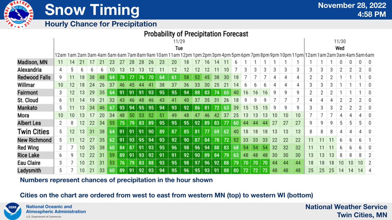
Tuesday's snowstorm is on track to hit the Minneapolis-St. Paul metro area at about 5 a.m.


TWIN CITIES, MN — The National Weather Service has issued a winter storm warning for the Twin Cities metro area, including Hennepin, Ramsey, Washington, Carver, Scott, and Dakota County.
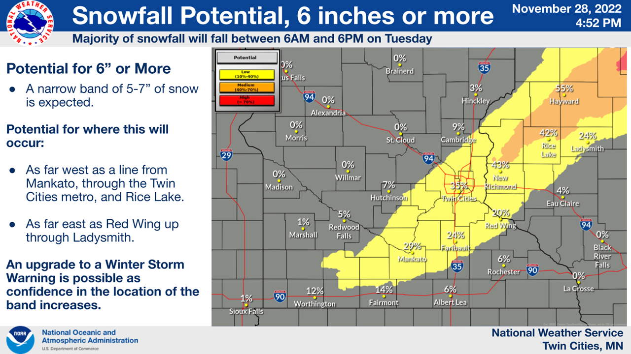
"Heavy snow expected. Total snow accumulations of 4 to 7 inches, with locally higher amounts possible," the National Weather Service said. "Plan on slippery road conditions. The hazardous conditions will impact the morning and evening commutes."
The storm will be active between 5 a.m. through 6 p.m. on Tuesday. NWS warned that travelers should keep an extra flashlight, food, and water in their vehicles.
Find out what's happening in Southwest Minneapolisfor free with the latest updates from Patch.
Here's the likely timing of the snowstorm:
Though unlikely, there is a chance the metro could see more than 6 inches of snow, the NWS notes.
Find out what's happening in Southwest Minneapolisfor free with the latest updates from Patch.
Here's the full NWS forecast from the Minneapolis-St. Paul Airport:
Monday Night: Snow likely, mainly after 5am. Cloudy, with a low around 28. Southwest wind around 5 mph becoming north after midnight. Chance of precipitation is 60%. Total nighttime snow accumulation of less than a half inch possible.
Tuesday: Snow, mainly before 4pm. The snow could be heavy at times. High near 31. North wind 5 to 15 mph. Chance of precipitation is 100%. New snow accumulation of 4 to 8 inches possible.
Tuesday Night: A 20 percent chance of snow before 9pm. Mostly cloudy, with a low around 18. West northwest wind around 15 mph, with gusts as high as 30 mph.
Wednesday: Partly sunny, with a high near 24. Blustery, with a west wind 15 to 20 mph, with gusts as high as 35 mph.
Wednesday Night: Mostly clear, with a low around 10. West wind 5 to 15 mph becoming south southwest after midnight.
Thursday: Mostly sunny, with a high near 30. South southeast wind 5 to 15 mph.
Thursday Night: Partly cloudy, with a low around 27. South wind 10 to 15 mph.
Friday: Mostly cloudy, with a high near 40. South wind 10 to 15 mph becoming west in the afternoon.
Friday Night: Mostly cloudy, with a low around 16. West northwest wind around 15 mph.
Saturday: Sunny, with a high near 23. West northwest wind 10 to 15 mph.
Saturday Night: Partly cloudy, with a low around 12. South wind 5 to 10 mph.
Sunday: Partly sunny, with a high near 32. South wind around 10 mph.
Sunday Night: Mostly cloudy, with a low around 19. South wind 5 to 10 mph becoming northwest after midnight.
Monday: A 20 percent chance of snow. Partly sunny, with a high near 28. North northwest wind around 10 mph.
Get more local news delivered straight to your inbox. Sign up for free Patch newsletters and alerts.


