Crime & Safety
Severe Thunderstorm Warnings Issued As New Round Of Destructive Weather Targets NJ
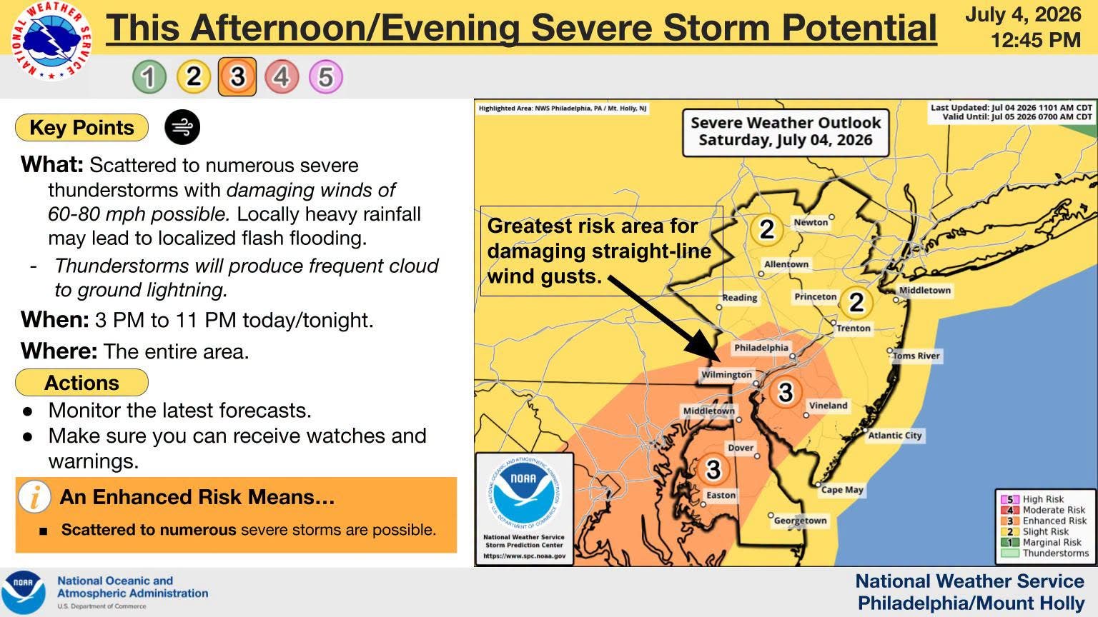
Wind gusts of 60 to 80 mph are possible Saturday evening along with more thunderstorms, the National Weather Service said.


A severe thunderstorm warning was in effect for parts of North Jersey Saturday evening as the Garden State is still reeling from Friday evening’s destructive storm aftermath and Saturday’s dangerous heat.
The warning said the severe thunderstorm was located over Echo Lake, or 16 miles west of Newton, at 6:50 p.m. The storm was expected to affect a wide stretch of northern New Jersey, including Newton, Montague, Dover, Hopatcong, Lincoln Park, Kinnelon, Boonton, Butler, Wharton, Rockaway, Mount Arlington, Franklin, Mountain Lakes, Stanhope, Riverdale, Hamburg, Ogdensburg and Sussex.
According to the warning from the National Weather Service, the storm carried a hazard of 60 mph wind gusts and quarter-size hail. The source for the warning was listed as radar indicated.
Find out what's happening in Across New Jerseyfor free with the latest updates from Patch.
Motorists could also see impacts on Interstate 80 in New Jersey. The warning said the storm includes areas along the highway between mile markers 32 and 40, and between mile markers 46 and 48.
The storm arrives as the cleanup continues from severe thunderstorms that pounded the Garden State Friday and robbed more than 250, 000 residents and businesses of power.
The damage was so severe that service restoration estimates have been extended into Wednesday next week. And some regions have yet to be given a restoration time.
Find out what's happening in Across New Jerseyfor free with the latest updates from Patch.
Several towns have canceled their Fourth of July fireworks because of new storm threat, and others because of the amount of downed trees and powerlines that have closed roads.
NJ Transit service also was affected by downed trees and lines, with some route canceled. NJ Transit buses were cross-honoring passes, the company said.
The National Weather Service Mount Holly office said there is an enhanced risk of another round of serious storms packing straight-line winds and gusts of up to 60 to 80 mph.
Storm damage
In Burlington County a church was struck by lightning and caught fire, and there were multiple reports of trees down on vehicles and homes across the state.
The fire at the Worship Center at Fellowship Alliance Chapel in Medford ripped through the roof of the church.
"Thankfully, nobody was in the building at the time so nobody was hurt," the church's leadership said.
First Energy was reporting more than 138,000 Jersey Central Power & Light customers without electricity as of 1 p.m. Saturday and PSE&G was reporting 23,701 on their respective websites.
Jersey Central Power & Light has more than 1,700 employees working to restore service, said Chris Hoenig, a spokesman fro the company. That included more than 800 line workers and 500 forestry workers, as well as hazard responders, substation electricians and support personnel.
The company was requesting additional line, substation and forestry crews from its mutual aid partners and contractors, Hoenig said.
"Our crews, joined by additional contractor crews and support personnel, have been working 16-hour shifts on storm rotation since earlier this week due to the extreme heat," he said. "This is going to be a long response and we are working through our protocols, including damage assessment and crew workplanning, to ensure that the information we provide to our customers is as accurate as possible and they can use that to make whatever plans are necessary.
JCP&L expected to have estimated restoration times available later Saturday, he said.
Towns that have canceled fireworks displays include Belleville, Plainfield, East Brunswick, Chatham Borough, Collingswood, and Millville. Other towns had canceled or postponed displays on Friday because of the forecast, including Denville.
Morris County was hardest hit, followed by Monmouth County, but many parts of the state took a beating.
"There were reports of 71 MPH winds in Newark," said David Wally with the National Weather Service. "There were reports of straight line wind damage. It kind of went from Sussex County, northwest to southeast, across the Newark area, through Hudson County and Staten Island, along that corridor, then into the ocean."
Wally said a microburst would probably take place over a smaller area. He noted winds of 67 MPH in Bayonne.
The Morris County Office of Emergency Management was urging people to only call 911 for true emergencies because of the volume of calls they were receiving.
Roxbury Township police said trees had fallen on homes and vehicles, trapping people inside, and urged residents to be patient for responses to situations that are not immediately life-threatening.
A portion of Route 46 East was closed because of the storm's aftermath.
"Our officers, firefighters, EMS, and DPW crews are actively responding to life-threatening emergencies," Roxbury police said. "If you are calling to report a tree or wires down that is not creating an immediate danger to life or safety please let dispatch know your call is NOT an emergency, and please understand that your call may have to wait while we respond to these critical incidents. If you are experiencing a true emergency, call 911 immediately."
In Hoboken, the storms blew debris all over the NJ Transit tracks, NJ Transit said.
Trees were toppled all over the city because of the microburst, authorities said.
Marlboro Township in Monmouth County had a lengthy list of road closures due to downed trees and wires, including portions of Route 79, Tennent Road, Robertsville Road, Crine Road and Gordons Corner Road.
"Please avoid these areas and seek alternate routes whenever possible. Avoid travel unless it is absolutely necessary," Marlboro police said.
Howell Township had nearly 9,000 customers without power, and firefighters had to battle a house fire that was related to the storm.
The Monmouth County Sheriff's Office was urging people to report power outages to JCP&L and to stay clear of downed power lines.
The impact of the storms was significantly less in the southern part of the state, with the number of customers without power dropping to less than 1,000 after 11:30 p.m.
Send your storm photos with your name and town to Karen Wall at karen.wall@patch.com. Please only send photos you took, and grant us permission to publish them on Patch with updates on the storm.
Get more local news delivered straight to your inbox. Sign up for free Patch newsletters and alerts.