Weather
Tropical Storm Debby: Latest Forecast For NJ Impacts
A cold front will dump several inches of rain on New Jersey, and that's before Hurricane Debby impacts the region. See the latest forecast:

NEW JERSEY — Part of new Jersey have been placed under a severe storm warning as more than five inches of rain, severe thunderstorms across most of the state and flash flooding are all possible Tuesday into Wednesday for New Jerseyans, and that's before Hurricane Debby heads up north, according to the latest forecast.
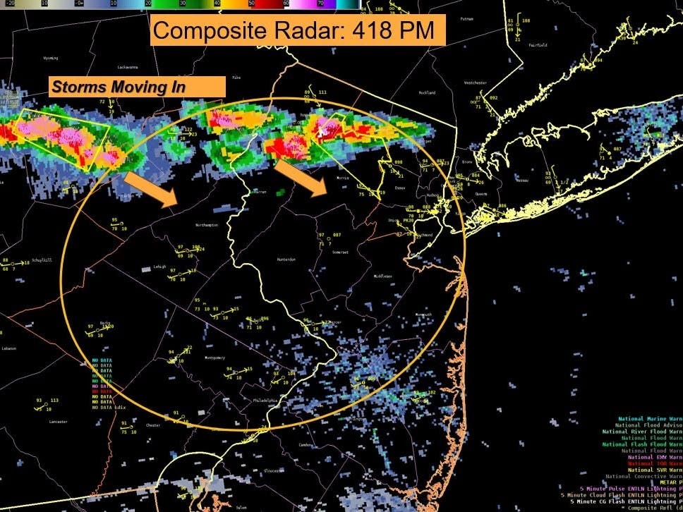
As of 4:32 p.m. the National Weather Service has issued a severe thunderstorm warning for southeastern Hunterdon County in northwestern New Jersey, Somerset County in northern New Jersey and northwestern Middlesex County in northern New Jersey
Locations include but are not limited to:
Find out what's happening in Across New Jerseyfor free with the latest updates from Patch.
- New Brunswick
- Somerville
- Somerset
- East Brunswick
- Bridgewater,
- North Brunswick
- Middlesex
- Bound Brook
- Manville
- Flemington,
- Millstone
- Skillman
- Flagtown
- Belle Mead
- Martinsville
- North Brunswick Township
- Kendall Park
- Cloverhill
- Society Hill
- South Plainfield
More warnings are expected as the storms move through the area in the evening.
Much of New Jersey is at risk for severe storms starting Tuesday afternoon and into tonight, National Weather Service forecasters said. Localized damaging downburst wind gusts from severe thunderstorms and small hail are possible here. AccuWeather forecasters predict possible gusts of up to 70 mph, which is just under hurricane strength.
Find out what's happening in Across New Jerseyfor free with the latest updates from Patch.
Heavy rain may also cause scattered to widespread flash flooding across much of the Garden State, particularly in urban areas, the National Weather Service said. A flood watch is in effect from 2 p.m. Tuesday through Wednesday morning for most of NJ.
It'll generally range 1.5 to 2.5 inches of rainfall, the National Weather Service said, but locally could exceed more than 5 inches.
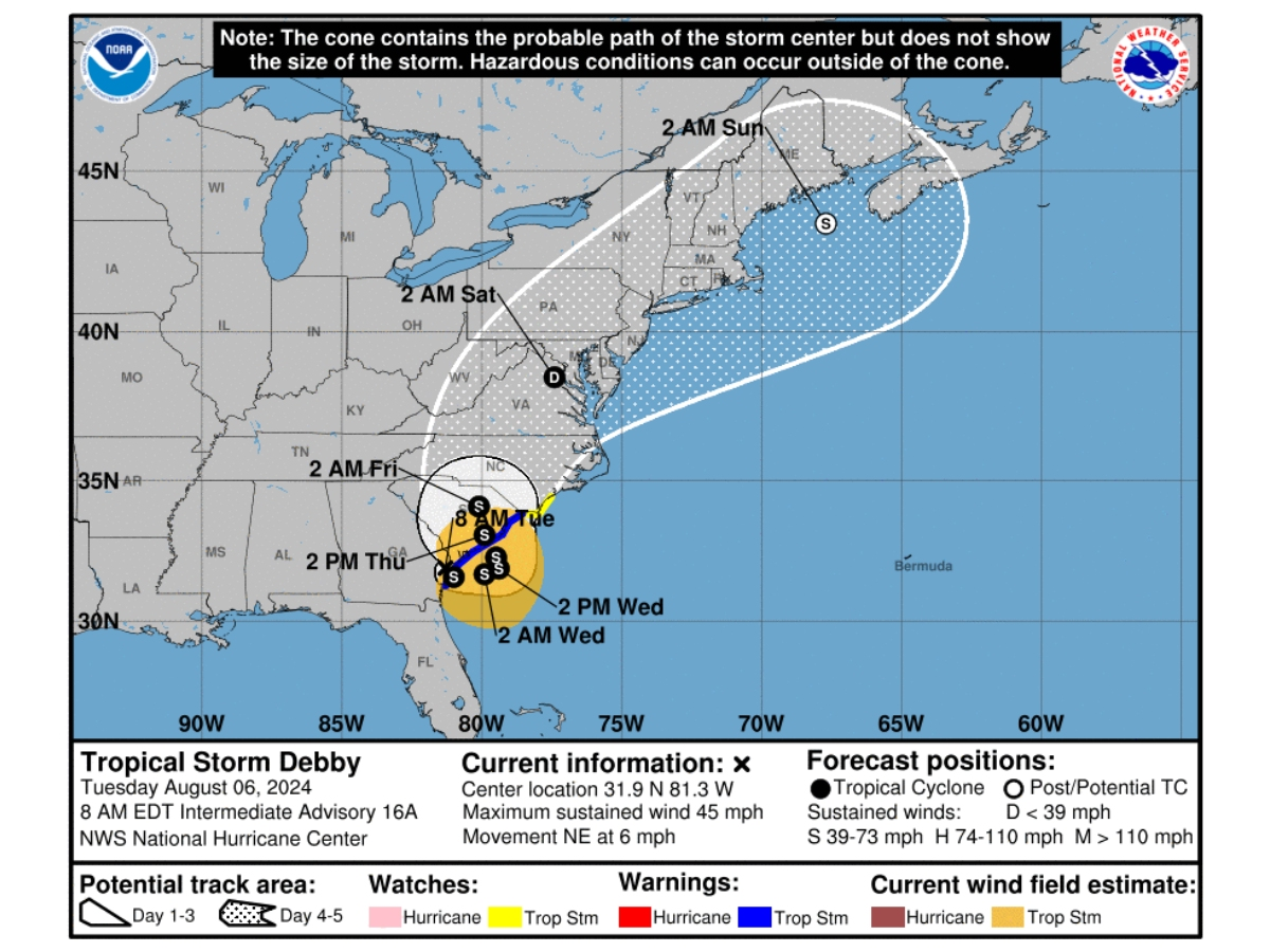
This heavy rain is coming from a cold front from the west, according to forecasters. Things will only continue as Hurricane Debby tracks north into the Mid-Atlantic region (see graphic below).
According to the early estimates from the National Weather Service, the remnants of Debby will likely past through the mid-Atlantic region over the weekend, likely Saturday. Specific details on the impacts and timing are forthcoming.

"Tropical air from the periphery of Debby's influence will push up into the frontal zone from Tuesday to Wednesday, adding water to the air that will, in turn, be squeezed out," AccuWeather Senior Meteorologist Dave Dombek explained. "This will enhance the downpours and correspondingly raise rainfall amounts to a higher level than if there had been no tropical moisture in the first place."
Much of what's in store later this week is still uncertain, forecasters say.
"The good news is this type of tropical airmass setup and overall environment shouldn't bring anything too concerning severe weather wise," National Weather Service forecasters said of what's in store through Thursday night. "The bad news is of course that the environment will stay favorable for excessive rainfall leading to flooding concerns."
Direct impacts from Debby will likely hit New Jersey at the end of this week into the weekend. It's yet to be seen what exact impacts will occur as it depends on the tracking and strength of the storm.
Here's the latest forecast.
North Jersey
Tuesday: A chance of showers and thunderstorms between noon and 2pm, then showers likely and possibly a thunderstorm after 2pm. Some of the storms could produce heavy rainfall. Partly sunny, with a high near 88. Heat index values as high as 96. West wind around 7 mph becoming southeast in the afternoon. Chance of precipitation is 70%. New rainfall amounts between a quarter and half of an inch possible.
Tuesday Night: Showers and possibly a thunderstorm. Some of the storms could produce heavy rainfall. Low around 67. East wind around 7 mph becoming north in the evening. Chance of precipitation is 90%. New rainfall amounts between three quarters and one inch possible.
Wednesday: Showers likely and possibly a thunderstorm. Cloudy, with a high near 72. Northeast wind around 11 mph. Chance of precipitation is 70%. New rainfall amounts between a tenth and quarter of an inch, except higher amounts possible in thunderstorms.
Wednesday Night: A 40 percent chance of showers. Mostly cloudy, with a low around 66. Northeast wind 6 to 8 mph.
Thursday: A 40 percent chance of showers and thunderstorms. Mostly cloudy, with a high near 78. East wind 9 to 11 mph, with gusts as high as 22 mph.
Thursday Night: Showers likely and possibly a thunderstorm. Mostly cloudy, with a low around 69. Chance of precipitation is 70%. New rainfall amounts between a half and three quarters of an inch possible.
Friday: Showers and possibly a thunderstorm. High near 79. Chance of precipitation is 90%.
Friday Night: Showers and possibly a thunderstorm. Low around 70. Chance of precipitation is 80%.
Central Jersey
Tuesday: A chance of showers and thunderstorms, then showers and possibly a thunderstorm after 2pm. High near 90. Heat index values as high as 100. Southwest wind around 5 mph. Chance of precipitation is 80%. New rainfall amounts between a quarter and half of an inch possible.
Tuesday Night: Showers and possibly a thunderstorm before 8pm, then showers and thunderstorms likely between 8pm and 10pm, then showers and possibly a thunderstorm after 10pm. Some of the storms could produce heavy rainfall. Low around 69. East wind around 5 mph becoming west after midnight. Chance of precipitation is 90%. New rainfall amounts between three quarters and one inch possible.
Wednesday: Showers and possibly a thunderstorm. Some of the storms could produce heavy rainfall. High near 77. Northeast wind 5 to 10 mph. Chance of precipitation is 80%. New rainfall amounts between a quarter and half of an inch possible.
Wednesday Night: A chance of showers and thunderstorms. Cloudy, with a low around 65. Northeast wind 5 to 10 mph. Chance of precipitation is 50%. New rainfall amounts between a tenth and quarter of an inch, except higher amounts possible in thunderstorms.
Thursday: A chance of showers, then showers likely and possibly a thunderstorm after 2pm. Mostly cloudy, with a high near 76. East wind around 10 mph, with gusts as high as 20 mph. Chance of precipitation is 70%. New rainfall amounts between a quarter and half of an inch possible.
Thursday Night: Showers and possibly a thunderstorm. Low around 69. Chance of precipitation is 80%. New rainfall amounts between a quarter and half of an inch possible.
Friday: Showers and possibly a thunderstorm. High near 81. Chance of precipitation is 90%.
Friday Night: Showers and possibly a thunderstorm. Low around 71. Chance of precipitation is 80%.
South Jersey
Tuesday: A chance of showers and thunderstorms between 3pm and 5pm, then showers likely and possibly a thunderstorm after 5pm. Mostly sunny, with a high near 90. Heat index values as high as 101. Southwest wind 5 to 10 mph. Chance of precipitation is 60%. New rainfall amounts of less than a tenth of an inch, except higher amounts possible in thunderstorms.
Tuesday Night: Showers and thunderstorms likely, then showers and possibly a thunderstorm after 2am. Some of the storms could produce heavy rainfall. Low around 71. South wind around 5 mph. Chance of precipitation is 80%. New rainfall amounts between a quarter and half of an inch possible.
Wednesday: Showers and possibly a thunderstorm. Some of the storms could produce heavy rainfall. High near 79. South wind around 5 mph becoming northeast in the morning. Chance of precipitation is 80%. New rainfall amounts between three quarters and one inch possible.
Wednesday Night: Showers likely and possibly a thunderstorm. Mostly cloudy, with a low around 67. Northeast wind around 5 mph. Chance of precipitation is 60%. New rainfall amounts between a quarter and half of an inch possible.
Thursday: Showers likely and possibly a thunderstorm before 8am, then showers likely between 8am and 11am, then showers likely and possibly a thunderstorm after 11am. Mostly cloudy, with a high near 77. East wind around 10 mph, with gusts as high as 20 mph. Chance of precipitation is 70%. New rainfall amounts between a quarter and half of an inch possible.
Thursday Night: Showers and possibly a thunderstorm. Low around 71. Chance of precipitation is 80%. New rainfall amounts between a quarter and half of an inch possible.
Friday: Showers, with thunderstorms also possible after 8am. High near 81. Chance of precipitation is 80%.
Friday Night: Showers likely and possibly a thunderstorm. Mostly cloudy, with a low around 72. Chance of precipitation is 70%
Get more local news delivered straight to your inbox. Sign up for free Patch newsletters and alerts.