Weather
Severe Thunderstorms, Triple-Digit Heat Index Forecast For NJ Thursday
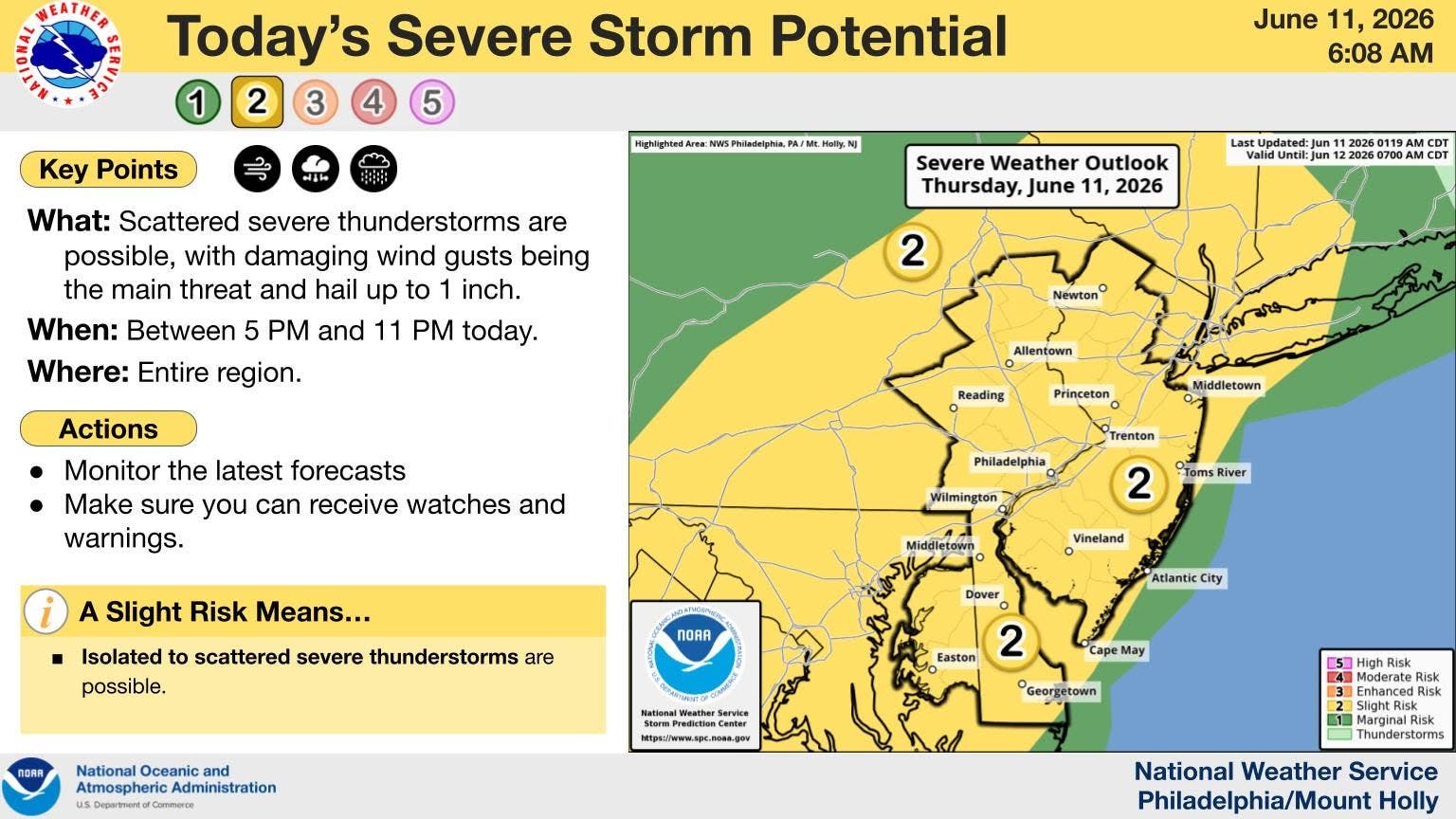
"Storms could produce damaging wind gusts and brief heavy downpours, as well as hail up to quarter size," said the National Weather Service.

Record-approaching high heat and humidity could bring severe thunderstorms and damaging winds to New Jersey on Thursday.
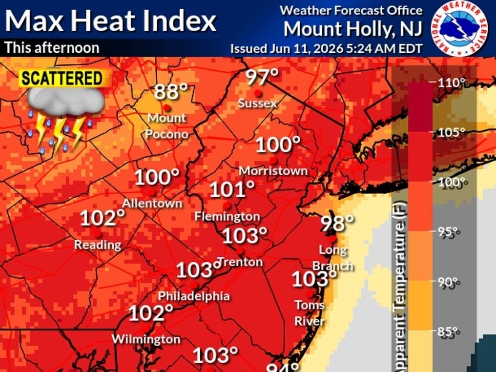
"The hottest heat indices so far this year are expected today, topping out near 100 degrees this afternoon in most areas," according to The National Weather Service(NWS).
Temperatures are expected to hover around near record-breaking highs in the low to mid 90s.
Find out what's happening in Across New Jerseyfor free with the latest updates from Patch.
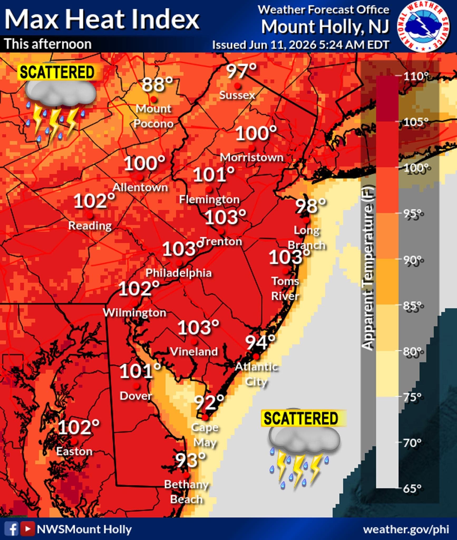
And it is not just for Thursday. The hot and humid conditions are expected to remain on Thursday and Friday, prompting a Heat Advisory for portions of the Garden State.
The extreme weather is expected to produce scattered severe thunderstorms in the late afternoon/evening on Thursday.
Find out what's happening in Across New Jerseyfor free with the latest updates from Patch.
The risk of severe storms will be greater than on Wednesday, with damaging winds as the main threat, according to the NWS.
"Storms could produce damaging wind gusts and brief heavy downpours, as well as hail up to quarter-size. Main timing will be between 5 to 11 p.m," according to the NWS.
Here is a look at the upcoming forecast:
North Jersey
Thursday: A 30 percent chance of showers and thunderstorms after 5 p.m. Partly sunny, with a high near 95. Heat index values as high as 103. West wind 6 to 9 mph.
Thursday Night: A chance of showers and thunderstorms before 11 p.m., then a slight chance of showers between 11 p.m. and 2 a.m. Mostly cloudy, with a low around 74. West wind 3 to 8 mph. Chance of precipitation is 40 percent.
Friday: Showers likely and possibly a thunderstorm after 5 p.m. Increasing clouds, with a high near 96. Heat index values as high as 104. Light northwest wind becoming west 5 to 10 mph in the morning. Chance of precipitation is 60 percent.
Friday Night: Showers and thunderstorms likely before 11 p.m., then a chance of showers between 11 p.m. and 2 a.m. Mostly cloudy, then gradually becoming mostly clear, with a low around 70. Northwest wind 8 to 10 mph. Chance of precipitation is 60 percent.
Saturday: Sunny, with a high near 90. Northwest wind around 8 mph.
Saturday Night: Mostly clear, with a low around 70.
Sunday: Mostly sunny, with a high near 93.
Sunday Night: Showers likely, mainly between 8 p.m. and 2 a.m. Mostly cloudy, with a low around 67. Chance of precipitation is 70 percent.
Central Jersey
Thursday: A chance of showers and thunderstorms, mainly after 5 p.m. Some of the storms could be severe. Partly sunny, with a high near 95. Heat index values as high as 103. West wind 5 to 10 mph. Chance of precipitation is 30 percent. New rainfall amounts of less than a tenth of an inch, except higher amounts possible in thunderstorms.
Thursday Night: Showers and thunderstorms likely, mainly before 11 p.m. Some of the storms could be severe. Mostly cloudy, with a low around 70. West wind around 5 mph becoming calm. Chance of precipitation is 60 percent. New rainfall amounts of less than a tenth of an inch, except higher amounts possible in thunderstorms.
Friday: A chance of showers and thunderstorms, then showers likely and possibly a thunderstorm after 5pm. Increasing clouds, with a high near 96. Heat index values as high as 104. Light west wind increasing to 5 to 10 mph in the morning. Chance of precipitation is 60 percent. New rainfall amounts of less than a tenth of an inch, except higher amounts possible in thunderstorms.
Friday Night: Showers likely and possibly a thunderstorm before 8 p.m., then a chance of showers and thunderstorms between 8 p.m. and 2 a.m. Mostly cloudy, then gradually becoming mostly clear, with a low around 66. Northwest wind around 5 mph. Chance of precipitation is 60 percent. New rainfall amounts of less than a tenth of an inch, except higher amounts possible in thunderstorms.
Saturday: Sunny, with a high near 90. Northwest wind around 5 mph.
Saturday Night: Mostly clear, with a low around 63.
Sunday: Mostly sunny, with a high near 92.
Sunday Night: Showers likely between 8pm and 2am. Mostly cloudy, with a low around 63. Chance of precipitation is 70 percent.
South Jersey
Thursday: Partly sunny and hot, with a high near 97. Heat index values as high as 103. West wind 5 to 10 mph.
Thursday Night: A chance of showers and thunderstorms, mainly before 1 a.m. Some of the storms could be severe. Mostly cloudy, with a low around 72. West wind around 5 mph becoming calm. Chance of precipitation is 50 percent. New rainfall amounts between a tenth and quarter of an inch, except higher amounts possible in thunderstorms.
Friday: Mostly sunny, with a high near 95. Heat index values as high as 101. West wind around 5 mph.
Friday Night: A chance of showers and thunderstorms before 2am. Mostly cloudy, with a low around 70. West wind around 5 mph. Chance of precipitation is 50 percent. New rainfall amounts of less than a tenth of an inch, except higher amounts possible in thunderstorms.
Saturday: Sunny, with a high near 91. Northwest wind around 5 mph.
Saturday Night: Mostly clear, with a low around 67.
Sunday: Mostly sunny, with a high near 89.
Sunday Night: Showers likely and possibly a thunderstorm between 8 p.m. and 2 a.m., then a chance of showers after 2 a.m. Mostly cloudy, with a low around 67. Chance of precipitation is 70 percent.
Get more local news delivered straight to your inbox. Sign up for free Patch newsletters and alerts.