Weather
Winter Weather Advisory Issued In 6 NJ Counties Ahead Of Storm
The National Weather Service has issued a winter weather advisory in six New Jersey counties.


NEW JERSEY — A cross-country storm will unleash a wintry mix into the Northeast from Thursday to Friday, forecasters predict. Several New Jersey counties will be under a winter weather advisory.
While parts of New Jersey will receive snow and ice, much of the state can expect rain and heavy winds, the National Weather Service predicts. Coastal flooding is also possible. The wintry weather could interfere with Thursday's commutes, according to the agency.
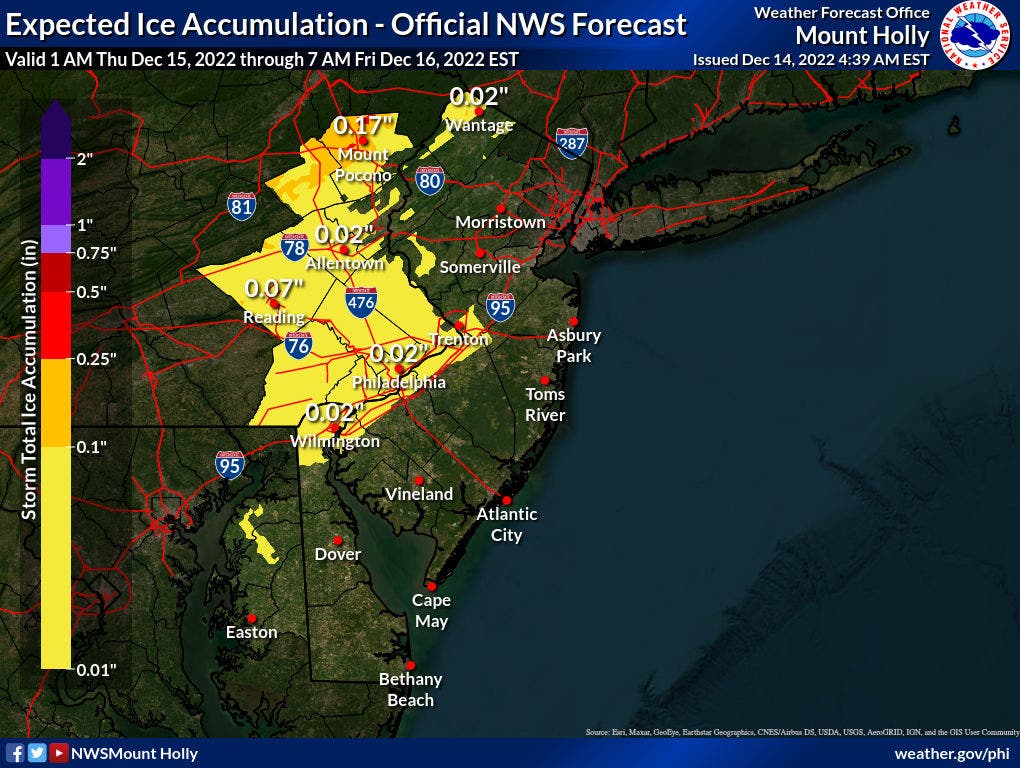
The National Weather Service has issued a winter weather advisory in six New Jersey counties. The advisory for Camden, Salem, Gloucester, northwestern Burlington will run from 5 a.m. to noon Thursday, while Sussex and Warren counties have an advisory running from noon to midnight Thursday.
Find out what's happening in Across New Jerseyfor free with the latest updates from Patch.

In the advisory for the central and southwestern portions of the state, the National Weather Service expects slippery road conditions during the Thursday morning commute. The mix of snow, sleet and freezing rain could last up to a few hours before shifting to rain from south to north by Thursday afternoon, the agency says.

In Sussex and Warren Counties, plan on slippery roads that could impact the Thursday evening commute. That mix of snow, sleet and freezing rain will move eastward into the area around midday Thursday, according to the National Weather Service. This may last several hours before changing to rain that night, the agency says. The area could get 1-2 inches of snow with a light glaze of ice.
Find out what's happening in Across New Jerseyfor free with the latest updates from Patch.
High-tide cycles on Thursday night and Friday afternoon may bring minor flooding to coastal New Jersey, according to the National Weather Service. Monmouth and Ocean Counties are most likely to endure coastal floods. Gusts near 45 mph along the coast could result in minor tree and power line damage from late Thursday afternoon through Friday morning, the agency says.

AccuWeather anticipates an icy mix for northwestern New Jersey on Thursday, which will become a combination of rain and snow Friday. The rest of the state will endure rain during that timeframe, according to the weather platform.
Heavy rainfall, combined with gusty winds, could lead to poor travel conditions and localized flooding in urban areas throughout New Jersey, according to AccuWeather.
"Motorists are likely to encounter ponding and poor visibility, while airline delays will be possible due to visibility, wind and slick runways at the major hubs," AccuWeather says.
Here's the National Weather Service's latest North Jersey forecast:
- Thursday: A slight chance of rain and sleet before 1pm, then rain. High near 44. Wind chill values between 25 and 35. East wind 6 to 11 mph, with gusts as high as 22 mph. Chance of precipitation is 80 percent. Little or no sleet accumulation expected.
- Thursday night: Rain. Steady temperature around 42. East wind 13 to 17 mph, with gusts as high as 33 mph. Chance of precipitation is 100 percent. New precipitation amounts between 1 and 2 inches possible.
- Friday: Rain. High near 47. East wind 11 to 17 mph becoming north in the afternoon. Winds could gust as high as 34 mph. Chance of precipitation is 90 percent. New precipitation amounts between a quarter and half of an inch possible.
- Friday night: Mostly cloudy, with a low around 33.
- Saturday: Sunny, with a high near 42.
- Saturday night: Partly cloudy, with a low around 28.
- Sunday: Mostly sunny, with a high near 38.
Here's the agency's latest South Jersey forecast:
- Thursday: Rain. High near 49. Breezy, with an east wind 10 to 15 mph increasing to 15 to 20 mph in the afternoon. Winds could gust as high as 30 mph. Chance of precipitation is 100 percent. New precipitation amounts between a quarter and half of an inch possible.
- Thursday night: Rain before 10 p.m., then rain and possibly a thunderstorm between 10 p.m. and 4 a.m., then rain after 4 a.m. Low around 49. Windy, with an east wind 25 to 30 mph, with gusts as high as 45 mph. Chance of precipitation is 100 percent. New rainfall amounts between three-quarters and one inch possible.
- Friday: A chance of rain, mainly before 1 p.m. Mostly cloudy, with a high near 50. Breezy, with a southeast wind 10 to 15 mph becoming west 15 to 20 mph in the morning. Winds could gust as high as 35 mph. Chance of precipitation is 40 percent. New precipitation amounts of less than a tenth of an inch possible.
- Friday night: Partly cloudy, with a low around 35.
- Saturday: Sunny, with a high near 45. Breezy.
- Saturday night: Partly cloudy, with a low around 29.
- Sunday: Sunny, with a high near 40. Breezy.
Get more local news delivered straight to your inbox. Sign up for free Patch newsletters and alerts.