Weather
Coastal Flooding Risk In NJ Tuesday Night; Hurricane Franklin Affecting Beaches
High rip currents are possible in ocean waters through Wednesday evening. At least one beach is closed.


NEW JERSEY — Rough surf and potentially dangerous rip currents are putting a bit of a damper on the last week of summer at the Jersey Shore, with coastal flooding also a risk as a hurricane churns offshore.
Hurricane Franklin, which is a Category 4 with winds of more than 140 miles per hour, is expected to stay far out in the Atlantic Ocean as it passes northwest of Bermuda. But vacationers and residents along the East Coast should prepare for the possibility of dangerous swimming conditions and beach closures as the storm's impacts may last several days, said AccuWeather forecasters.
The chance of rain and scattered showers will increase in the region overnight Tuesday into Wednesday, added the National Weather Service.
Find out what's happening in Across New Jerseyfor free with the latest updates from Patch.
"Expect the bulk of the rainfall and most thunderstorm activity to hold off until near or after midnight," NWS forecasters said.
Heavy rain is possible at times, meteorologists said. And with the extra moisture and wind from Franklin, plus the approaching full moon, minor coastal flooding is a risk for areas with the high tide.
Find out what's happening in Across New Jerseyfor free with the latest updates from Patch.
A coastal flood advisory is in effect until at least midnight Wednesday for parts of of Monmouth, Atlantic, Cape May, Ocean, Cumberland, Salem, Camden, Gloucester, and Burlington counties.
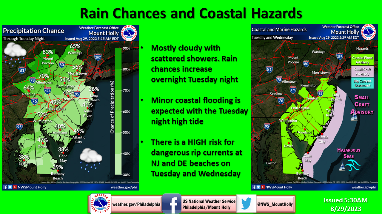
“Do not park your vehicle in areas prone to flooding and do not drive through flood waters,” advised NWS forecasters.
High rip currents are possible in ocean waters through Wednesday evening. At least one beach is closed.
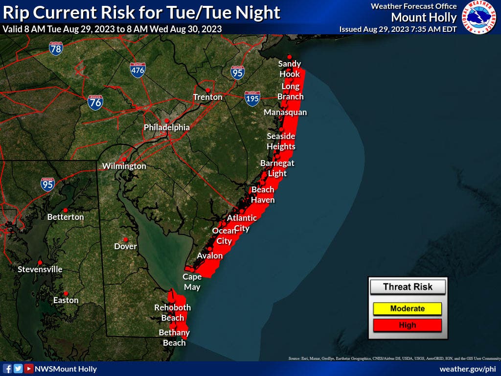
The risk for dangerous rip currents at New Jersey and New York City beaches continues into at least Wednesday, said forecasters.
“Strong swells from distant Hurricane Franklin will result in an elevated rip current risk through late this week," forecasters said.
The wind-whipped seas will be hazardous, and there is a small craft advisory through Wednesday for seas over 5 feet.
Current tracking models show that Hurricane Franklin "will pass far enough northwest of Bermuda to limit significant impacts," but it will still bring gusty winds and rough surf to portions of the archipelago, said AccuWeather.
And, residents of Florida and Georgia are bracing for Hurricane Idalia, which should strengthen to an "extremely dangerous major hurricane" by landfall in the Sunshine State on Wednesday. The remnants of this storm should stay south of the mid-Atlantic, forecasters said.
“Four to 8 inches of rain is expected to span across a large portion of the Southeast coastline with 2-4 inches expected to dampen regions as far inland as central Georgia, western South Carolina and central North Carolina,” AccuWeather said.
Here is a look at the forecast in around New Jersey through Wednesday, from the National Weather Service:
North Jersey
Tuesday night: Showers likely and possibly a thunderstorm, mainly after 2am. Cloudy, with a low around 68. Southeast wind around 6 mph becoming calm in the evening. Chance of precipitation is 70 percent. New rainfall amounts of less than a tenth of an inch, except higher amounts possible in thunderstorms.
Wednesday: Showers likely and possibly a thunderstorm before 8am, then scattered showers and thunderstorms between 8am and 2pm. Cloudy through mid morning, then gradual clearing, with a high near 83. South wind 5 to 9 mph becoming northwest in the afternoon. Chance of precipitation is 60 percent. New rainfall amounts between a tenth and quarter of an inch, except higher amounts possible in thunderstorms.
Wednesday night: Partly cloudy, with a low around 58. Northwest wind around 10 mph.
Central Jersey
Tuesday afternoon: Mostly cloudy, with a high near 80. East wind around 5 mph.
Tuesday night: A chance of showers and thunderstorms, then showers likely and possibly a thunderstorm after 4am. Patchy fog after 9pm. Otherwise, mostly cloudy, with a low around 70. East wind around 5 mph becoming calm in the evening. Chance of precipitation is 60 percent. New rainfall amounts of less than a tenth of an inch, except higher amounts possible in thunderstorms.
Wednesday: Showers and thunderstorms likely before 11am, then a slight chance of showers between 11am and 1pm. Cloudy through mid morning, then gradual clearing, with a high near 85. Southwest wind 5 to 10 mph becoming northwest in the afternoon. Chance of precipitation is 60 percent. New precipitation amounts of less than a tenth of an inch, except higher amounts possible in thunderstorms.
Wednesday night: Mostly cloudy, with a low around 61. North wind 5 to 10 mph.
South Jersey
Tuesday afternoon: A chance of showers, mainly after 4pm. Mostly cloudy, with a high near 80. East wind around 10 mph. Chance of precipitation is 30 percent.
Tuesday night: A chance of showers and thunderstorms before 1am, then a slight chance of showers between 1am and 3am, then a slight chance of showers and thunderstorms after 3am. Patchy fog after 8pm. Otherwise, mostly cloudy, with a low around 70. East wind around 5 mph becoming calm. Chance of precipitation is 30 percent. New rainfall amounts of less than a tenth of an inch, except higher amounts possible in thunderstorms.
Wednesday: A chance of showers and thunderstorms before noon, then a slight chance of showers between noon and 1pm. Cloudy, then gradually becoming mostly sunny, with a high near 86. Southwest wind 5 to 10 mph becoming northwest in the afternoon. Chance of precipitation is 40 percent. New precipitation amounts of less than a tenth of an inch, except higher amounts possible in thunderstorms.
Wednesday night: Mostly cloudy, with a low around 61. Northwest wind around 10 mph.
Get more local news delivered straight to your inbox. Sign up for free Patch newsletters and alerts.


