Weather
Fast-Moving Storms, Heavy Rain In Tuesday Forecast For NJ: See Latest
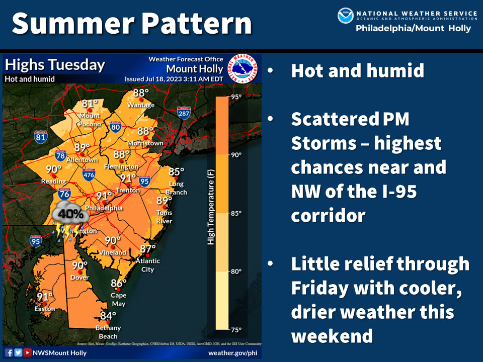
Hot and humid temperatures will pave the way for scattered afternoon and evening storms, weather forecasters said.

NEW JERSEY — Watch for fast-moving thunderstorms Tuesday that could again bring heavy downpours and gusty winds to New Jersey this afternoon and later tonight, said forecasters.
Hot and humid temperatures in the high 80s and low 90s will pave the way for scattered afternoon storms, the National Weather Service said.
“Heavy downpours will be a concern, along with isolated severe weather,” said the NWS.
Find out what's happening in Across New Jerseyfor free with the latest updates from Patch.
As Tuesday afternoon progresses, the highest chances of storms will be near and northwest of the I-95 corridor (the highway enters New Jersey in Burlington County and cuts northeast to Bergen County). A flood advisory is in effect until tonight for parts of Bergen, Essex, Hudson, and Union counties.
According to Accuweather.com, the thunderstorms are expected to move quickly, which gives waterways more time to absorb the rain and carry it downstream.
Find out what's happening in Across New Jerseyfor free with the latest updates from Patch.
“However, the risk of flash flooding in urban areas and along small streams will continue since there is still enough water in the atmosphere to lead to the development of torrential downpours,” added Accuweather forecasters.
Aside from wet weather, the region is also slated for bad air on Tuesday afternoon.
Hazy conditions from the Canadian wildfires are in the forecast, with much of the state under an air quality alert as AQIs in some areas are expected to reach triple digits by Tuesday afternoon, forecasters said.
The New Jersey Department of Environmental Protection issued a code orange air quality action day through Tuesday night for northern and central New Jersey. Air quality within the region “may approach or exceed unhealthy standards," officials said.
The Code Orange will be in place for 16 counties: Sussex, Warren, Morris, Hunterdon, Somerset, Middlesex, Monmouth, Mercer, Salem, Gloucester, Camden, Burlington, Ocean, Cumberland, Atlantic and Cape May.
Read more — NJ Air Quality Index To Hit Triple Digits Tuesday: See Forecast
Additional rounds of storms are expected through at least Friday before seasonable, dry weather returns this weekend, according to Accuweather and the National Weather Service.
Here is an extended forecast for New Jersey, courtesy of the National Weather Service:
North Jersey
Tuesday: Showers and thunderstorms likely, mainly between 2pm and 5pm. Some of the storms could produce gusty winds and heavy rain. Mostly cloudy, with a high near 90. Heat index values as high as 96. Southwest wind around 8 mph. Chance of precipitation is 60 percent. New rainfall amounts between a tenth and quarter of an inch, except higher amounts possible in thunderstorms.
Tuesday Night: A 30 percent chance of showers and thunderstorms, mainly before 8pm. Partly cloudy, with a low around 70. South wind around 5 mph becoming light and variable in the evening.
Wednesday: A slight chance of showers between 8am and 2pm, then a chance of showers and thunderstorms after 2pm. Partly sunny, with a high near 89. Light and variable wind becoming west around 5 mph in the afternoon. Chance of precipitation is 30 percent.
Wednesday Night: A chance of showers and thunderstorms before 2am, then a slight chance of showers. Mostly cloudy, with a low around 69. Light and variable wind becoming northeast around 5 mph after midnight. Chance of precipitation is 30 percent.
South Jersey
Tuesday: A chance of showers and thunderstorms. Sunny, with a high near 90. Southwest wind around 10 mph. Chance of precipitation is 30 percent. New rainfall amounts of less than a tenth of an inch, except higher amounts possible in thunderstorms.
Tuesday Night: A slight chance of showers and thunderstorms, then a chance of showers after 4am. Mostly clear, with a low around 69. Southwest wind around 5 mph becoming calm. Chance of precipitation is 30 percent. New precipitation amounts of less than a tenth of an inch, except higher amounts possible in thunderstorms.
Wednesday: A chance of showers and thunderstorms before 11am, then showers likely and possibly a thunderstorm between 11am and noon, then a chance of showers and thunderstorms after noon. Partly sunny, with a high near 88. West wind 5 to 10 mph becoming southeast in the morning. Chance of precipitation is 60 percent. New rainfall amounts of less than a tenth of an inch, except higher amounts possible in thunderstorms.
Wednesday Night: A chance of showers and thunderstorms. Mostly cloudy, with a low around 68. Southwest wind around 5 mph becoming calm. Chance of precipitation is 30 percent. New rainfall amounts of less than a tenth of an inch, except higher amounts possible in thunderstorms.
Patch’s Nicole Rosenthal contributed to this report.
Get more local news delivered straight to your inbox. Sign up for free Patch newsletters and alerts.


