Weather
Forecasters Tracking Tropical Storm Philippe: See Potential NJ Impacts
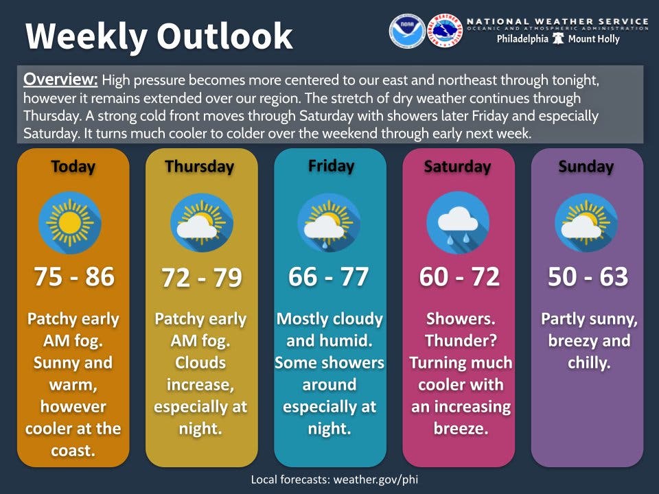
Temperatures will drop this weekend in New Jersey, and there is an increasing chance for wet weather, according to forecasters.


NEW JERSEY — Another stretch of heavy rain looks possible in parts of New Jersey this weekend, and forecasters are tracking Tropical Storm Philippe as it is expected to sweep into the northeast U.S.
The major areas of impact for Philippe look to be further northeast of New Jersey, though the storm could kick up winds on the coast and add to local precipitation levels, forecasters said. The outlook could change for the East Coast if the storm's path shifts closer to the state, just one week after post-Tropical Storm Ophelia slammed the Garden State with heavy rain.
"Philippe’s rain may become intermingled with two other systems over parts of the Northeast," AccuWeather forecasters said.
Find out what's happening in Across New Jerseyfor free with the latest updates from Patch.
Late Wednesday morning, Philippe was dumping heavy rain over the Leeward Islands in the northern Caribbean. The National Hurricane Center said the storm was moving north-northwest near 7 miles per hour, but is expected to move faster as it goes northward. Bermuda is under a Tropical Storm Watch, as the National Hurricane Center predicts the center of Philippe will approach the island territory on Thursday or Friday.
After Philippe passes Bermuda, the storm is likely to track northwest and make landfall near the Maine and New Brunswick border this weekend, per forecasters.
Find out what's happening in Across New Jerseyfor free with the latest updates from Patch.
As for what this means for New Jersey residents, Philippe could add to what is already looking like another wet weekend. Though temperatures have been warm, AccuWeather and the National Weather Service predict much cooler weather to have settled into the region by the end of the week, with rain starting to increase Friday night and increasing Saturday as a strong cold front moves through.
"Some moisture from Philippe will get drawn into the region and combine with the cold front to bring rain and thunderstorms Saturday to the Middle Atlantic and Northeast," AccuWeather forecasters said. "Within this area of rain there will likely be bands of heavy rain setting up that can lead to flash flooding."
Heavy downpours are possible on Saturday, bringing the risk of flash flooding and travel disruptions, said AccuWeather forecasters.
“No weather setup is exactly the same, and there are some differences with the setup in the Northeast from Friday night to Sunday compared to a week ago,” AccuWeather meteorologists said. “However, there does appear to be room for a plume of tropical moisture to feed into the Northeast, likely farther to the east of New York City, which may lead to flash flooding and major travel disruptions.”
Localized flooding will still be possible in spots, with the rainfall moderate to heavy at times.
"The risk for serious flooding will be increased for locations that have already had heavy rainfall in recent weeks and where the ground is already saturated, especially if downpours persist over these same areas," said AccuWeather Chief Meteorologist Jonathan Porter.
The Weather Channel also predicts a lower amount of rainfall in the region than last weekend, when floods disrupted travel in the New York City metro and some New Jersey towns were deluged with up to 9 inches of rain.
“A majority of the rain falling in the Northeast Friday into this weekend will be from a cold front slicing across the region,” added The Weather Channel. “Much cooler air and gusty winds will follow right behind that front's passage.”
Here is the extended forecast for New Jersey, from the National Weather Service:
North Jersey
Wednesday Night: Clear, with a low around 55. Calm wind.
Thursday: Sunny, with a high near 78. Calm wind becoming south 5 to 7 mph in the afternoon.
Thursday Night: Patchy fog after 4am. Otherwise, increasing clouds, with a low around 56. Calm wind.
Friday: A 50 percent chance of showers, mainly after 8am. Patchy fog before 10am. Otherwise, mostly cloudy, with a high near 73. Light and variable wind.
Friday Night: Showers likely, mainly after 2am. Cloudy, with a low around 62. Chance of precipitation is 70 percent. New precipitation amounts between a tenth and quarter of an inch possible.
Saturday: Showers. High near 67. Chance of precipitation is 80 percent.
Saturday Night: Showers likely, mainly before 8pm. Partly cloudy, with a low around 47. Chance of precipitation is 60 percent.
Sunday: Mostly sunny, with a high near 58.
Central Jersey
Wednesday Night: Mostly clear, with a low around 54. South wind around 5 mph becoming calm in the evening.
Thursday: Mostly sunny, with a high near 79. Calm wind becoming southeast around 5 mph in the afternoon.
Thursday Night: Increasing clouds, with a low around 62. Southeast wind around 5 mph becoming calm after midnight.
Friday: A slight chance of showers after 9am. Cloudy, with a high near 76. Light east wind becoming southeast 5 to 10 mph in the afternoon. Chance of precipitation is 20 percent.
Friday Night: Showers likely, mainly after 3am. Cloudy, with a low around 63. Chance of precipitation is 60 percent. New precipitation amounts between a tenth and quarter of an inch possible.
Saturday: Showers likely. Mostly cloudy, with a high near 69. Chance of precipitation is 70 percent.
Saturday Night: Showers likely before 9pm. Partly cloudy, with a low around 49. Chance of precipitation is 60 percent.
Sunday: Mostly sunny, with a high near 60. Breezy.
South Jersey
Wednesday Night: Mostly clear, with a low around 53. South wind around 5 mph becoming calm.
Thursday: Mostly sunny, with a high near 77. Light and variable wind becoming southeast 5 to 10 mph in the afternoon.
Thursday Night: Mostly cloudy, with a low around 62. East wind around 5 mph becoming calm after midnight.
Friday: A slight chance of showers after 2pm. Mostly cloudy, with a high near 76. Southeast wind 5 to 10 mph. Chance of precipitation is 20 percent.
Friday Night: A chance of showers, mainly after 2am. Mostly cloudy, with a low around 61. Chance of precipitation is 40 percent. New precipitation amounts of less than a tenth of an inch possible.
Saturday: Showers likely, mainly between 8am and 2pm. Mostly cloudy, with a high near 70. Chance of precipitation is 70 percent.
Saturday Night: A chance of showers before 8pm. Partly cloudy, with a low around 47. Chance of precipitation is 30 percent.
Sunday: Mostly sunny, with a high near 61. Breezy.
Get more local news delivered straight to your inbox. Sign up for free Patch newsletters and alerts.


