Weather
Heavy Downpours, Storms In Wednesday Forecast For NJ: See Latest
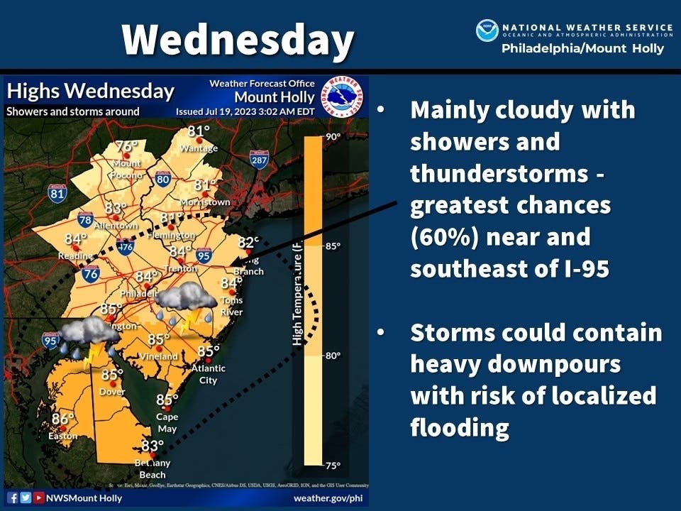
Heavy rains and more localized flooding are the main concerns with storms moving in Wednesday, said forecasters.

NEW JERSEY —The threat of flooding remains in New Jersey as storms carrying heavy rain move in Wednesday morning, and forecasters say to expect more storms later in the day.
More localized flooding is the main concern with the weather moving in Wednesday. According to the National Weather Service, clouds will increase in the region this morning before showers and thunderstorms break out across parts of the state.
“Expect the first wave this morning, then more activity this afternoon with dry time in between,” said forecasters.
Find out what's happening in Across New Jerseyfor free with the latest updates from Patch.
“(The) best concentration of rain this morning appears to be near Philadelphia into central NJ, with moisture having trouble getting further north as the front dropping southward stalls out,” the NWS added.
Storms this afternoon will also remain stalled in the southern portions of the state, with northwest New Jersey “quite possibly staying dry.”
Find out what's happening in Across New Jerseyfor free with the latest updates from Patch.
Forecasters said flash flooding is possible, as the ground is saturated with rainwater in a number of areas.
“Widespread severe weather is unlikely but we can't rule out isolated instances of damaging winds and localized flooding with the highest threats being over SE PA, southern NJ, and Delmarva," said the National Weather Service.
Accuweather.com said some areas of the state could see between 2 and 4 inches of rain in a 48-hour period by the time Wednesday is out.
"Thunderstorms into Wednesday are expected to move faster than the storms from this past weekend and last week which should help to mitigate a widespread flood threat," AccuWeather Senior Meteorologist Adam Douty said.
"However, because of the saturated state of the ground in many areas due to the recent heavy rain across the region, downpours can still trigger flash flooding more easily than would typically occur," Douty explained.
At least five people are confirmed dead after flood waters swept away vehicles in Bucks County, Pa. on Saturday. Search efforts to find two children missing from the deadly flooding has been postponed Wednesday, and possibly called off.
Here is Wednesday’s forecast around New Jersey, courtesy of the National Weather Service:
North Jersey
Wednesday: A 30 percent chance of showers and thunderstorms, mainly between 11am and 2pm. Mostly cloudy, with a high near 85. South wind 3 to 5 mph.
Wednesday night: Partly cloudy, with a low around 68. Light and variable wind.
Central Jersey
Wednesday: Showers likely and possibly a thunderstorm before 2pm, then showers and thunderstorms likely between 2pm and 5pm, then showers likely and possibly a thunderstorm after 5pm. Some of the storms could produce heavy rain. Mostly cloudy, with a high near 84. East wind around 5 mph. Chance of precipitation is 70 percent. New rainfall amounts between a tenth and quarter of an inch, except higher amounts possible in thunderstorms.
Wednesday night: A chance of showers and thunderstorms before 8pm. Mostly cloudy, with a low around 66. Southeast wind around 5 mph becoming calm. Chance of precipitation is 30 percent. New precipitation amounts of less than a tenth of an inch, except higher amounts possible in thunderstorms.
South Jersey
Wednesday: Showers likely and possibly a thunderstorm before 2pm, then a chance of showers and thunderstorms after 2pm. Some of the storms could produce heavy rain. Mostly cloudy, with a high near 85. South wind 5 to 10 mph. Chance of precipitation is 60 percent. New rainfall amounts of less than a tenth of an inch, except higher amounts possible in thunderstorms.
Wednesday night: A chance of showers and thunderstorms, mainly before 8pm. Some of the storms could produce heavy rain. Patchy fog after 3am. Otherwise, mostly cloudy, with a low around 67. East wind around 5 mph becoming calm. Chance of precipitation is 30 percent. New precipitation amounts of less than a tenth of an inch, except higher amounts possible in thunderstorms.
Get more local news delivered straight to your inbox. Sign up for free Patch newsletters and alerts.


