Weather
Heavy Rain, Floods, 'Dangerous' Windchills As Christmas-Week Storm Nears NJ
The storm system could produce significant floods, black ice and some snow, according to forecasters.


NEW JERSEY — The weather outside will be frightful. Updated forecasts for the days leading up to Christmas show heavy rain, a wintry mix, intense winds and the potential for significant flooding in New Jersey — all leading to "dangerously" low wind chills that may make this the coldest Christmas in decades.
The rain could significantly reduce visibility on the roads, with intense drops in temperature potentially leading to scattered black ice. The same storm system will unleash a blizzard in the Midwest, so the large storm area may lead to major airline delays and a large number of flight cancelations, AccuWeather warns.
.jpg)
The coastal-flood threat will run from 7 a.m. through 7 p.m. Friday, according to the National Weather Service. The tides, combined with heavy rain, could significantly inundate New Jersey's coastal communities. The weather agency issued coastal flood-watch advisories for the following areas:
Find out what's happening in Across New Jerseyfor free with the latest updates from Patch.
- Hudson, eastern Essex, eastern Union Counties (Friday morning)
- Monmouth and Middlesex Counties (late Thursday morning through Friday morning)
The rest of New Jersey's coastline could endure minor flooding, with the potential for locally moderate flooding, during the Friday morning and afternoon high-tide cycles.
Here's what else you should know.
Find out what's happening in Across New Jerseyfor free with the latest updates from Patch.
Rain (Lots Of It)
Widespread rainfall totals range from 1-3 inches, with the National Weather Service anticipating 2-3 inches in North Jersey from Thursday through Friday.
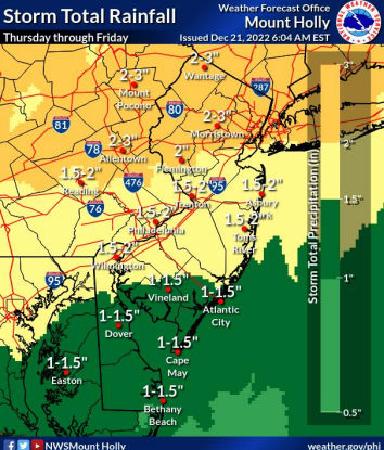
The heaviest rain will fall from 7 p.m. Thursday through 7 a.m. Friday, which could produce minor flooding on low-lying roads and around rivers, streams and creaks, the National Weather Service says.
The precipitation will depart by Saturday, according to forecasters. AccuWeather gave New Jersey a "poor" travel outlook for Friday and fair travel outlooks for Thursday and Saturday.
.jpg)
.jpg)

Intense Cold
Temperatures will rapidly plummet from Friday afternoon to evening, as the cold front associated with the storm hits the region, AccuWeather says. For example, Philadelphia's Friday morning forecast shows the temperature hitting the mid- to upper-50s before plunging through the 20s that evening.
The cold front could produce "dangerously" cold wind chills as low as -20 degrees in the region, the National Weather Service says.
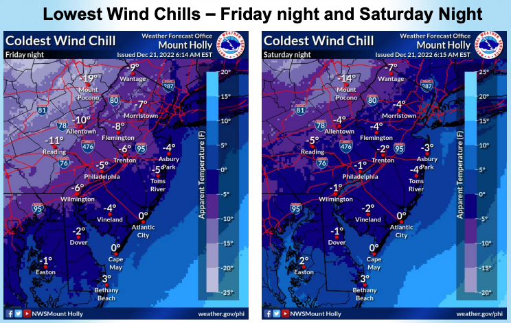
Scattered areas of black ice may develop across the state, the agency says. With snow showers and mixed precipitation possible in the region, the conditions could also lead to localized flash freezing of bridges and elevated surfaces.
"In many cases, the strong winds will blow the roads dry in the I-95 corridor in the wake of the cold front on Friday," said AccuWeather Senior MeteorologistJoe Lundberg. "However, there is the possibility that some surfaces may not have a chance to dry off and may rapidly freeze as people head home."
This will likely become New York City's coldest Christmas since 2000, when the high hit 27 and the low totaled 15 degrees, AccuWeather says. The city sustained its coldest Christmas on record in 1980, when temperatures bottomed out at 1 below zero.
Snow Too?
Snow may fall Thursday throughout the state Friday, with the highest confidence for snowfall in northern and southwestern New Jersey — toward the Philadelphia area — the National Weather Service says. But the agency expects little, if any, accumulation.
The agency's New York office anticipates scattered snow showers in northeast New Jersey late Friday afternoon into the evening.
Hold Onto Your Santa Inflatables
South winds will increase to 20-30 mph Thursday night, shifting sharply from the west behind a cold front on Friday, forecasters predict. But gusts of 45-55 mph across the state are possible late Thursday night through Friday evening, the National Weather Service says.
The strong winds will blow down scattered tree limbs and carry unsecured outdoor objects, the agency predicts. Make sure to secure any outdoor decorations.
Peak winds will occur from 11 p.m. Thursday through 5 p.m. Friday, according to weather officials.
Here's the National Weather Service's latest North Jersey forecast:
- Wednesday night: Increasing clouds, with a low around 29. Light and variable wind.
- Thursday: A slight chance of rain and snow before 10 a.m., then rain. High near 53. Northeast wind 5 to 11 mph, with gusts as high as 21 mph. Chance of precipitation is 90 percent. Little or no snow accumulation expected.
- Thursday night: Rain. Temperature rising to around 54 by 2 a.m. Breezy, with an east wind 13 to 22 mph, with gusts as high as 40 mph. Chance of precipitation is 100 percent. New precipitation amounts between 1 and 2 inches possible.
- Friday: Rain before 4 p.m., then a slight chance of snow showers. Some thunder is also possible. Temperature rising to near 54 by 9 a.m., then falling to around 25 during the remainder of the day. Breezy, with a south wind 21 to 24 mph becoming west in the afternoon. Winds could gust as high as 47 mph. Chance of precipitation is 100 percent. Little or no snow accumulation expected.
- Friday night: Partly cloudy, with a low around 13. Breezy.
- Saturday: Mostly sunny, with a high near 23.
- Saturday night: Mostly clear, with a low around 14.
- Sunday (Christmas): Sunny, with a high near 25.
- Sunday night: Mostly clear, with a low around 17.
Here's the agency's latest South Jersey forecast:
- Wednesday night: Mostly cloudy, with a low around 36. East wind around 5 mph.
- Thursday: Rain, mainly after 1 p.m. High near 52. East wind 10 to 15 mph, with gusts as high as 30 mph. Chance of precipitation is 90 percent. New precipitation amounts between a quarter and half of an inch possible.
- Thursday night: Rain, with thunderstorms also possible after 10 p.m. Low around 50. Windy, with a southeast wind 20 to 30 mph, with gusts as high as 45 mph. Chance of precipitation is 100 percent. New rainfall amounts between three-quarters and one inch possible.
- Friday: Rain before 4 p.m., then a chance of snow. High near 51. Windy, with a south wind 30 to 35 mph becoming west in the afternoon. Winds could gust as high as 50 mph. Chance of precipitation is 90 percent. Little or no snow accumulation expected.
- Friday night: A chance of snow before 7 p.m. Partly cloudy, with a low around 17. Windy. Chance of precipitation is 30 percent.
- Saturday: Mostly sunny, with a high near 25. Breezy.
- Saturday night: Mostly clear, with a low around 16. Breezy.
- Sunday (Christmas): Sunny, with a high near 28. Breezy.
- Sunday night: Mostly clear, with a low around 18.
Get more local news delivered straight to your inbox. Sign up for free Patch newsletters and alerts.