Weather
Hurricane Ian Forecast For NJ: Is The State In For Another Ida?
Forecasters expect heavy rain in NJ later this week. But there isn't a higher chance of danger to property or life here, AccuWeather says.


NEW JERSEY — Hurricane Ian, which approached Category 5 status on its way to Florida on Wednesday morning, could bring harsh weather to New Jersey. While predictions may change because of uncertainty in the storm's path, Ian could bring nearly a half-foot of rain to the Garden State, according to forecasters.
New Jersey is on track to receive the remnants of Ian, but remnants of a hurricane can still produce a strong storm. Last year, the remnants of Hurricane Ida brought three tornadoes, peak winds of 150 mph and nearly 10 inches of rain to parts of the Garden State. Ida killed 30 people in New Jersey, becoming the state's deadliest storm in recorded history besides Superstorm Sandy in 2012.
Find out what's happening in Across New Jerseyfor free with the latest updates from Patch.
As far as the Garden State goes, South Jersey has the best chance of getting heavy precipitation early, the National Weather Service says. Rainfall may begin Friday night, with early predictions of 1-1.5 inches of rain across South Jersey into Saturday. Another 2-4 inches could fall Sunday and Monday throughout the state, according to a forecast discussion from the agency's Mount Holly office.
"This could result in localized flooding, and a flood watch may be needed," says Wednesday morning's forecast discussion. "Although the heaviest rain currently looks to stay in the far southern and eastern portions of the area, will have to monitor trends to see if the heavier rain spreads northward."
Find out what's happening in Across New Jerseyfor free with the latest updates from Patch.
Fortunately for New Jersey, the wind projections fall far lower than Ida's speed.
"Gusty easterly winds will develop starting on Saturday and lasting into at least Monday, ranging from 15 to 20 mph with 20 to 30 mph gusts," the National Weather Service said.
But there's "some" chance that Ian remains strong enough to risk property damage and lives on New Jersey's southern coast, according to AccuWeather. The storm could bring flooding, destructive winds, power outages and isolated tornadoes to the area, according to AccuWeather's forecast.
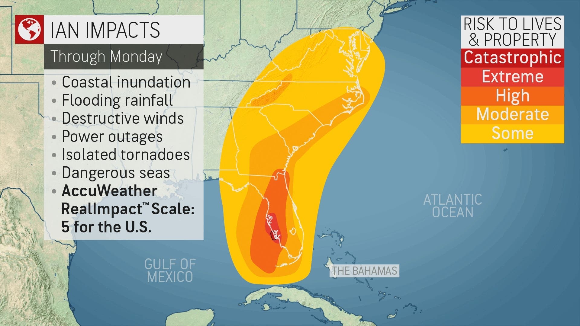
As of 10 a.m. Wednesday, Hurricane Ian packed 155 mph winds as it tore through the Florida Gulf Coast. That's only 2 mph shy of Category 5 intensity. AccuWeather rated Ian a 5 on its RealImpact Scale for the United States because of the dangers and anticipated magnitude of the flooding rainfall and heavy winds when Ian crashes onshore early Wednesday afternoon.
.jpg)
"There is the potential for Ian to hit as the strongest hurricane on record for the southwestern to west-central part of the Florida Gulf coast," said AccuWeather Hurricane Expert Dan Kottlowski.
Models show the hurricane moving toward the Tennessee Valley after slamming Florida on Wednesday and Thursday. But the National Weather Service said a "secondary low seems to split off it and tracks towards the Mid-Atlantic and east of New Jersey Saturday night through Sunday."
Before Ian arrives, New Jersey's forecast remains relatively calm, with mostly sunny skies in the coming days.
Here's the National Weather Service's latest North Jersey forecast:
- Wednesday: Mostly sunny, with a high near 71. West wind 6 to 8 mph.
- Wednesday night: Partly cloudy, with a low around 53. North wind around 7 mph.
- Thursday: Sunny, with a high near 69. North wind 7 to 10 mph.
- Thursday night: Partly cloudy, with a low around 50. North wind around 8 mph.
- Friday: Mostly sunny, with a high near 68. North wind around 7 mph.
- Friday night: Mostly cloudy, with a low around 56.
- Saturday: A 30 percent chance of rain after 9am. Mostly cloudy, with a high near 65.
- Saturday night: A 40 percent chance of rain. Mostly cloudy, with a low around 56.
- Sunday: A 40 percent chance of rain. Mostly cloudy, with a high near 67.
- Sunday night: A 40 percent chance of rain. Mostly cloudy, with a low around 53.
- Monday: A 40 percent chance of rain. Mostly cloudy, with a high near 62.
- Monday night: A 40 percent chance of showers. Mostly cloudy, with a low around 50.
- Tuesday: A 40 percent chance of showers. Partly sunny, with a high near 64.
Here's the agency's latest South Jersey forecast:
- Wednesday: Sunny, with a high near 68. Northwest wind around 10 mph.
- Wednesday night: Partly cloudy, with a low around 48. Calm wind becoming north around 5 mph after midnight.
- Thursday: Mostly sunny, with a high near 70. North wind 5 to 10 mph.
- Thursday night: Mostly cloudy, with a low around 45. Calm wind becoming northeast around 5 mph after midnight.
- Friday: Partly sunny, with a high near 71. East wind 5 to 10 mph, with gusts as high as 20 mph.
- Friday night: A chance of rain, mainly after 2 a.m. Mostly cloudy, with a low around 53. Chance of precipitation is 40 percent. New precipitation amounts of less than a tenth of an inch possible.
- Saturday: Rain likely, mainly after 8 a.m. Mostly cloudy, with a high near 68. Chance of precipitation is 70 percent.
- Saturday night: Rain likely. Mostly cloudy, with a low around 54. Chance of precipitation is 70 percent.
- Sunday: Rain likely. Mostly cloudy, with a high near 67. Chance of precipitation is 70 percent.
- Sunday night: Rain likely, mainly before 2 a.m. Mostly cloudy, with a low around 54. Chance of precipitation is 60 percent.
- Monday: A chance of rain. Mostly cloudy, with a high near 65. Chance of precipitation is 40 percent.
- Monday night: A chance of showers. Mostly cloudy, with a low around 53. Chance of precipitation is 40 percent.
- Tuesday: A chance of showers. Partly sunny, with a high near 69. Chance of precipitation is 30 percent.
Get more local news delivered straight to your inbox. Sign up for free Patch newsletters and alerts.