Weather
Will NJ Be Impacted By Ernesto? See Latest Forecast
While Ernesto is expected to stay offshore, swells generated by the storm are expected to reach the Jersey Shore in the coming days.

NEW JERSEY — Beachgoers should keep their eyes on the forecast in the coming days as Hurricane Ernesto is expected to bring strong rip currents and high waves to the Jersey Shore this weekend. Heavy rainfall is also expected in some parts of the state, according to forecasters.
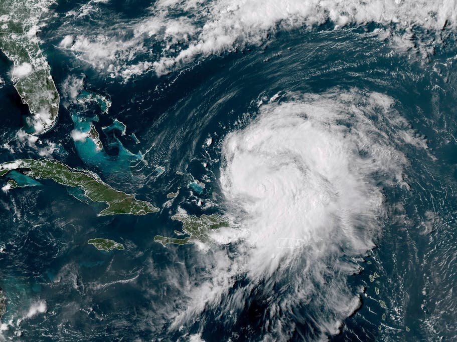
Ernesto dropped torrential rain on Puerto Rico and knocked out power for nearly half of all customers in the U.S. territory Wednesday as it threatened to strengthen into a major hurricane en route to Bermuda.
As of Thursday morning, the storm was over open water about 675 miles south-southwest of Bermuda with maximum sustained winds of 85 mph. The system was moving northwest at 16 mph, according to the National Hurricane Center.
Find out what's happening in Across New Jerseyfor free with the latest updates from Patch.
Forecasters said Ernesto is expected to move north through the Atlantic Ocean before turning to the northeast in the coming days.
While Ernesto is expected to stay well offshore, swells generated by the storm are expected to reach the Jersey Shore in the coming days, creating dangerous rip currents and surf conditions that will persist through the weekend.
Find out what's happening in Across New Jerseyfor free with the latest updates from Patch.
"Beachgoers should be aware of the significant risk... and stay out of the water if advised by lifeguards," the NHC said in a Thursday update.
According to the National Weather Service in Mount Holly, the Garden State could see yet another rainy weekend following last week's lashing by Hurricane Debby.
"Showers and thunderstorms well to our west during the day Friday are forecast to arrive into at least our western zones during the evening and spread eastward overnight," the NWS forecast states. "There may be multiple rounds of showers and some thunderstorms... with an increase especially later (Saturday) afternoon and evening."
Localized flash flooding is possible, according to forecasters.
Showers and thunderstorms are expected to continue into early next week as a cold front works its way across the area and then offshore, forecasters said.
Here's a look at the detailed NWS forecast through this weekend:
North Jersey
Thursday: Scattered showers and thunderstorms, mainly after 2pm. Mostly sunny, with a high near 87. Light northwest wind. Chance of precipitation is 30%.
Thursday Night: Scattered showers and thunderstorms before 8pm. Mostly clear, with a low around 64. Calm wind. Chance of precipitation is 30%.
Friday: Sunny, with a high near 88. Calm wind becoming south around 5 mph in the afternoon.
Friday Night: Mostly cloudy, with a low around 67. Light south wind.
Saturday: A 30 percent chance of showers after 2pm. Mostly cloudy, with a high near 81. Light southeast wind becoming south 5 to 10 mph in the morning.
Saturday Night: Showers likely, mainly after 8pm. Mostly cloudy, with a low around 67. Chance of precipitation is 60%. New precipitation amounts between a tenth and quarter of an inch possible.
Sunday: A chance of showers and thunderstorms, then showers likely and possibly a thunderstorm after 2pm. Mostly cloudy, with a high near 78. Chance of precipitation is 60%.
Central Jersey
Thursday: Sunny, with a high near 87. North wind around 5 mph.
Thursday Night: Mostly clear, with a low around 65. South wind around 5 mph becoming calm.
Friday: Mostly sunny, with a high near 90. Calm wind becoming southwest around 5 mph.
Friday Night: Mostly cloudy, with a low around 69. South wind around 5 mph.
Saturday: A chance of showers and thunderstorms after 2pm. Partly sunny, with a high near 84. South wind 5 to 10 mph. Chance of precipitation is 30%. New rainfall amounts of less than a tenth of an inch, except higher amounts possible in thunderstorms.
Saturday Night: A chance of showers and thunderstorms before 8pm, then showers likely and possibly a thunderstorm between 8pm and 2am, then a chance of showers and thunderstorms after 2am. Mostly cloudy, with a low around 69. Chance of precipitation is 60%. New rainfall amounts between a tenth and quarter of an inch, except higher amounts possible in thunderstorms.
Sunday: A chance of showers before 8am, then showers likely and possibly a thunderstorm after 2pm. Mostly cloudy, with a high near 83. Chance of precipitation is 60%.
South Jersey
Thursday: Sunny, with a high near 79. Northeast wind around 5 mph becoming southeast in the afternoon.
Thursday Night: Mostly clear, with a low around 67. Southwest wind around 5 mph.
Friday: Sunny, with a high near 82. West wind 5 to 10 mph becoming south in the afternoon.
Friday Night: Partly cloudy, with a low around 69. South wind around 10 mph.
Saturday: Partly sunny, with a high near 80. South wind 10 to 15 mph, with gusts as high as 25 mph.
Saturday Night: A chance of showers and thunderstorms. Mostly cloudy, with a low around 69. Chance of precipitation is 40%. New rainfall amounts of less than a tenth of an inch, except higher amounts possible in thunderstorms.
Sunday: A chance of showers and thunderstorms after 2pm. Partly sunny, with a high near 82. Chance of precipitation is 30%.
The Associated Press contributed to this report.
Get more local news delivered straight to your inbox. Sign up for free Patch newsletters and alerts.