Weather
Severe Thunderstorms Possible As Record-Breaking Heat Moves Into NJ
Some areas in New Jersey are under "slight risk" for severe thunderstorms as temperatures could reach the 90s, forecasters say.

As spring seems to have finally arrived in New Jersey this week, with it comes a forecast of severe thunderstorms, powerful wind gusts, and potentially record-breaking heat.
According to the National Weather Service, thunderstorms are in the cards for the Garden State Tuesday afternoon into the evening, with the more severe weather targeting North Jersey.
As of Tuesday morning, areas in North Jersey are under “slight risk” for severe weather, while other parts of North and Central Jersey are at a marginal risk. South Jersey can expect some moderate thunderstorms, or none at all, according to forecasters.
Find out what's happening in Across New Jerseyfor free with the latest updates from Patch.
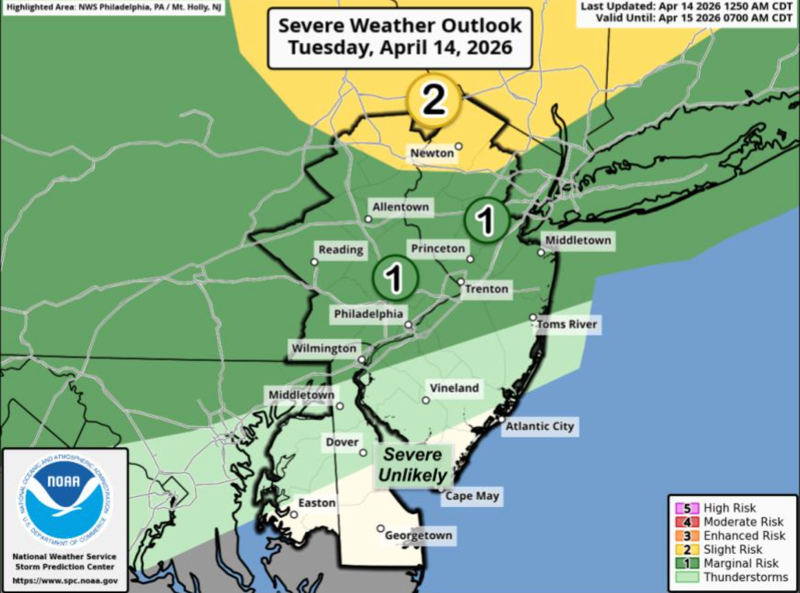
“The threat for showers and thunderstorms has increased for this afternoon and evening, mainly for areas along and north/west of the I-95 and I-195 corridor,” the National Weather Service announced. “A few strong to severe thunderstorms could produce damaging wind gusts.”
Officials added that the greatest chance of severe weather will be between 2 and 9 p.m. Tuesday, but isolated storms could still linger past 9 p.m.
Find out what's happening in Across New Jerseyfor free with the latest updates from Patch.
Weather experts say wind gusts may reach up to 60 mph in some parts of the state on Tuesday.
The storms and winds come as forecasters anticipate one of the warmest weeks in April recorded in New Jersey.
The average temperature in April for New Jersey is in the mid-60s, according to forecasters. The NHS predicts that temperatures will get as warm as 15 to 30 degrees above average.
Wednesday is expected to be the warmest day of the week, with temperatures reaching as high as 90 degrees in some parts of the state. Temperatures along the coast are expected to be relatively lower this week.
The highest recorded temperature in Trenton for April 15 is 87 degrees, which was set in 1994, according to the National Weather Service.
If temperatures reach 90, it will be the first 90-degree day of the year and the first since September.
Here’s the latest forecast:
North Jersey
Tuesday: Mostly sunny, with a high near 86. Light southwest wind increasing to 8 to 13 mph in the morning. Chance of severe thunderstorms in some areas.
Tuesday Night: Partly cloudy, with a low around 66. Southwest wind 5 to 8 mph.
Wednesday: A chance of showers between 2 p.m. and 5 p.m., then a chance of showers and thunderstorms after 5 p.m. Mostly sunny, with a high near 88. Southwest wind 5 to 11 mph. Chance of precipitation is 20 percent.
Wednesday Night: A chance of showers and thunderstorms before 11 p.m., then a chance of showers between 11 p.m. and 2 a.m. Mostly cloudy, with a low around 65. Southwest wind 3 to 7 mph. Chance of precipitation is 30 percent.
Thursday: Partly sunny, with a high near 86. Light southwest wind increasing to 5 to 10 mph in the morning.
Thursday Night: Mostly cloudy, with a low around 65.
Friday: A 40 percent chance of showers. Partly sunny, with a high near 80.
Friday Night: Mostly cloudy, with a low around 57.
Central Jersey
Tuesday: Mostly sunny, with a high near 86. Light southwest wind increasing to 10 to 15 mph in the afternoon.
Tuesday Night: A chance of showers and thunderstorms before 11p.m., then a slight chance of showers between 11 p.m. and midnight. Partly cloudy, with a low around 63. Southwest wind around 5 mph, becoming calm in the evening. Chance of precipitation is 30 percent. New precipitation amounts of less than a tenth of an inch, except higher amounts possible in thunderstorms.
Wednesday: A slight chance of showers after 2 p.m. Mostly sunny, with a high near 90. Light southwest wind increasing to 5 to 10 mph in the morning. Chance of precipitation is 20 percent.
Wednesday Night: A slight chance of showers before 2 a.m. Partly cloudy, with a low around 65. Southwest wind around 5 mph becoming calm in the evening. Chance of precipitation is 20 percent
Thursday: Partly sunny, with a high near 89. Light southwest wind becoming west 5 to 10 mph in the morning.
Thursday Night: A slight chance of showers. Mostly cloudy, with a low around 65. Chance of precipitation is 20 percent.
Friday: A chance of showers. Partly sunny, with a high near 81. Chance of precipitation is 40 percent.
Friday Night: Partly cloudy, with a low around 55.
South Jersey
Tuesday: Sunny, with a high near 87. Southwest wind 5 to 15 mph.
Tuesday Night: A chance of showers and thunderstorms before 11 p.m., then a slight chance of showers between 11 p.m. and midnight. Partly cloudy, with a low around 65. Southwest wind around 5 mph. Chance of precipitation is 30 percent. New precipitation amounts of less than a tenth of an inch, except higher amounts possible in thunderstorms.
Wednesday: Mostly sunny, with a high near 91. Southwest wind 5 to 10 mph.
Wednesday Night: A slight chance of showers before 2 a.m. Partly cloudy, with a low around 68. Southwest wind around 5 mph. Chance of precipitation is 20 percent.
Thursday: Partly sunny, with a high near 91. Southwest wind 5 to 10 mph.
Thursday Night: A slight chance of showers. Mostly cloudy, with a low around 67. Chance of precipitation is 20 percent.
Friday: A chance of showers after 8 a.m. Partly sunny, with a high near 83. Chance of precipitation is 40 percent.
Friday Night: Partly cloudy, with a low around 59.
With reporting by Veronica Flesher.
Get more local news delivered straight to your inbox. Sign up for free Patch newsletters and alerts.