Weather
Powerful Nor’easter Closes In On NJ Coast
The nor'easter is tracking closer to the New Jersey coast, bringing stronger winds and dangerous flooding.


NEW JERSEY— A developing nor’easter is tracking closer to the New Jersey coast than previously expected, raising the threat of damaging winds, dangerous surf and repeated rounds of coastal flooding through Saturday night.
“Damaging winds will blow down trees and power lines. Power outages are possible," the National Weather Service's latest brief read. "Travel will be difficult, especially for high profile vehicles."
Confidence in the coastal and marine threat has increased through Saturday night, while the forecast for Sunday remains less certain because impacts will depend heavily on the exact track of a developing storm offshore, according to the National Weather Service.
Find out what's happening in Across New Jerseyfor free with the latest updates from Patch.
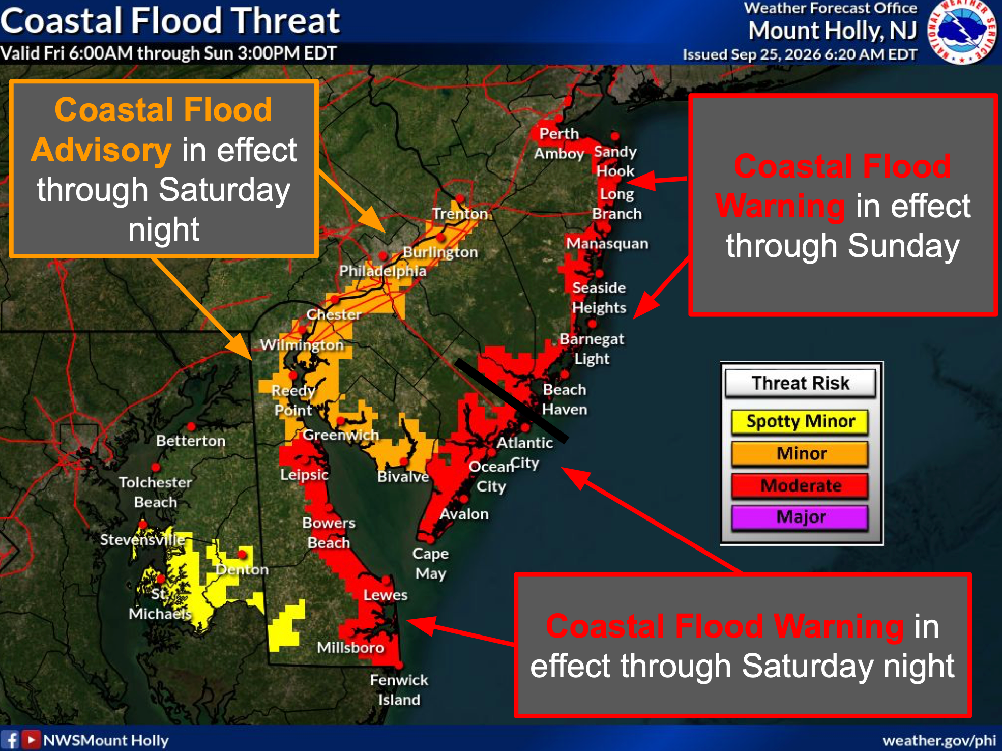
Some coastal and bayside roads could become impassable, while vulnerable structures could be damaged. Residents in flood-prone areas should avoid driving through flooded roads and should not park in locations known to flood.
Repeated rounds of minor to moderate tidal flooding are expected along portions of the Atlantic coast.
Find out what's happening in Across New Jerseyfor free with the latest updates from Patch.
The most significant impacts are expected in back-bay areas, including Barnegat Bay and the Shrewsbury River in New Jersey.
Coastal flooding is expected during multiple high-tide cycles through at least Saturday night and could continue into Sunday, particularly north of Atlantic City.
The highest tides are currently most likely Saturday morning and/or Saturday night.
The flooding threat is being driven by the combination of elevated tides and persistent northeast-to-north winds pushing water toward the coast.
How Strong Will The Winds Get?
Winds will become significantly stronger tonight and remain strong through Saturday night.
Along the Atlantic coasts of New Jersey, a High Wind Warning is in effect from 6 p.m. Friday through 6 a.m. Sunday.
The National Weather Service expects north winds of about 30 to 40 mph, with gusts up to 60 mph possible.
Farther inland, a Wind Advisory is in effect from 6 p.m. Friday through 6 a.m. Sunday for portions of New Jersey,
Inland areas could see north winds of 15 to 25 mph with gusts up to 45 mph, while some portions of southern New Jersey could see gusts approaching 50 mph.
The strongest winds are expected along the coast, where they could down tree limbs, damage vulnerable structures and cause scattered power outages.
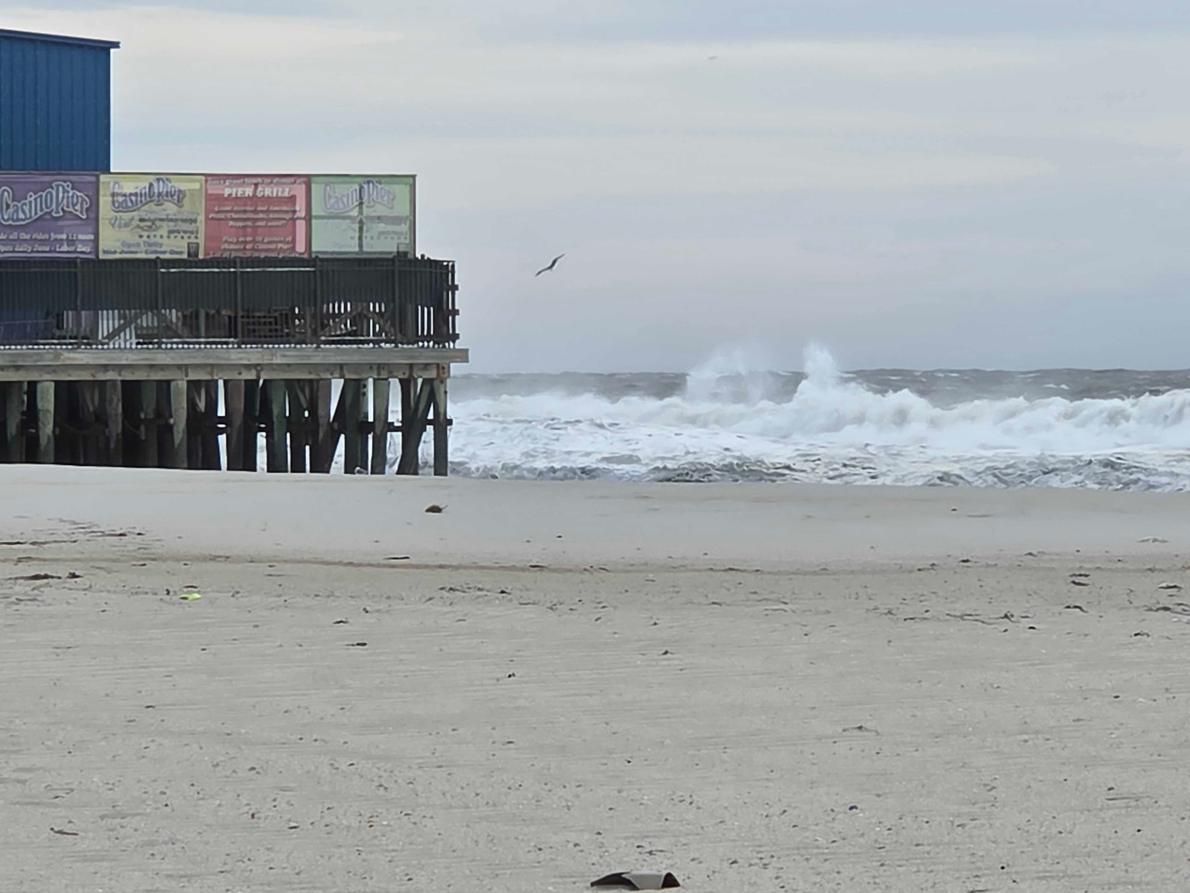
Gale-force winds are expected across the coastal waters, with seas building to roughly 8 to 20 feet. Storm-force gusts of up to 55 knots are possible across the Atlantic waters tonight through Saturday night.
Dune damage and possible dune breaches are also a concern, particularly where repeated high tides combine with strong onshore winds and large waves.
Beachgoers should stay out of the water in dangerous surf conditions and remain away from areas threatened by erosion or flooding.
What Happens Sunday?
Sunday remains the biggest forecast question.
If the developing storm tracks close to the New Jersey coast, significant coastal and marine impacts could continue into Sunday, including stronger winds, additional rain, dangerous surf and continued coastal flooding.
A storm track farther offshore would reduce the threat of the strongest inland rain and winds, but coastal communities could still experience flooding, rough surf and gusty winds.
The National Weather Service emphasized that confidence is high through Saturday night, but considerably lower for Sunday because of the storm's uncertain track.
Central New Jersey
Flooding: Southern Raritan Bay, the Shrewsbury River and other tidal waterways could see repeated flooding during high tides. Coastal and bayside roads may become difficult or impossible to travel.
Winds: Coastal areas will experience increasingly strong north winds tonight and Saturday, while inland areas could see gusts of 35 to 45 mph.
Weekend: Conditions will depend on the storm's track. A closer coastal track could prolong the strongest winds, rain and coastal flooding into Sunday.
Beach: Dangerous surf, a high rip-current risk and significant beach erosion are expected.
North Jersey
Flooding: Southern Raritan Bay and tidal portions of the Delaware River could experience repeated tidal flooding through the weekend.
Winds: Inland areas could see gusts up to around 45 mph, with stronger conditions closer to the coast. A Wind Advisory is in effect for much of the region beginning Friday evening. National Weather Service+1
Weekend: A storm track farther offshore would limit the strongest inland impacts, but coastal flooding and rough marine conditions could continue.
Temperatures: The region will remain cool through the weekend before warmer weather returns early next week.
South Jersey
Flooding: Coastal communities and back-bay areas around Barnegat Bay face repeated rounds of tidal flooding. The National Weather Service identifies back-bay areas as among those facing some of the most significant impacts. National Weather Service
Winds: Atlantic coastal areas could see sustained north winds of 30 to 40 mph, with gusts reaching 60 mph.
Surf: Dangerous surf, a high rip-current risk, significant beach erosion and possible dune breaches are expected through the weekend.
Weekend: A storm passing closer to the coast could bring heavier rain and stronger winds into Sunday. A track farther offshore would still leave coastal communities vulnerable to flooding, high seas and gusty winds.
Get more local news delivered straight to your inbox. Sign up for free Patch newsletters and alerts.