Weather
NJ Drought Deepens, Could Worsen As Reservoir Water Levels Fall
New Jersey has been confident but cautious about its water supply during this hot, dry stretch. But conditions worsened in recent days.

NEW JERSEY — The Garden State fell further into drought conditions, with little rain and some reservoirs showing lower water levels. New Jersey's drought levels remain unlikely to improve and may regress further because of little rainfall in the forecast this week, according to the National Weather Service.
New Jersey officials have been confident but cautious about the state's water supply — even after issuing a drought watch Aug. 9. The action is meant to raise awareness of the stress on the water supply and encourage voluntary conservation measures. But if the hot, dry conditions don't improve, New Jersey officials could issue a drought warning and then a drought emergency, which could entail mandatory water-conservation measures from the state for the first time in two decades.
Some of the state's reservoirs have fallen below normal water levels, according to data from the New Jersey Department of Environmental Protection.
Find out what's happening in Across New Jerseyfor free with the latest updates from Patch.
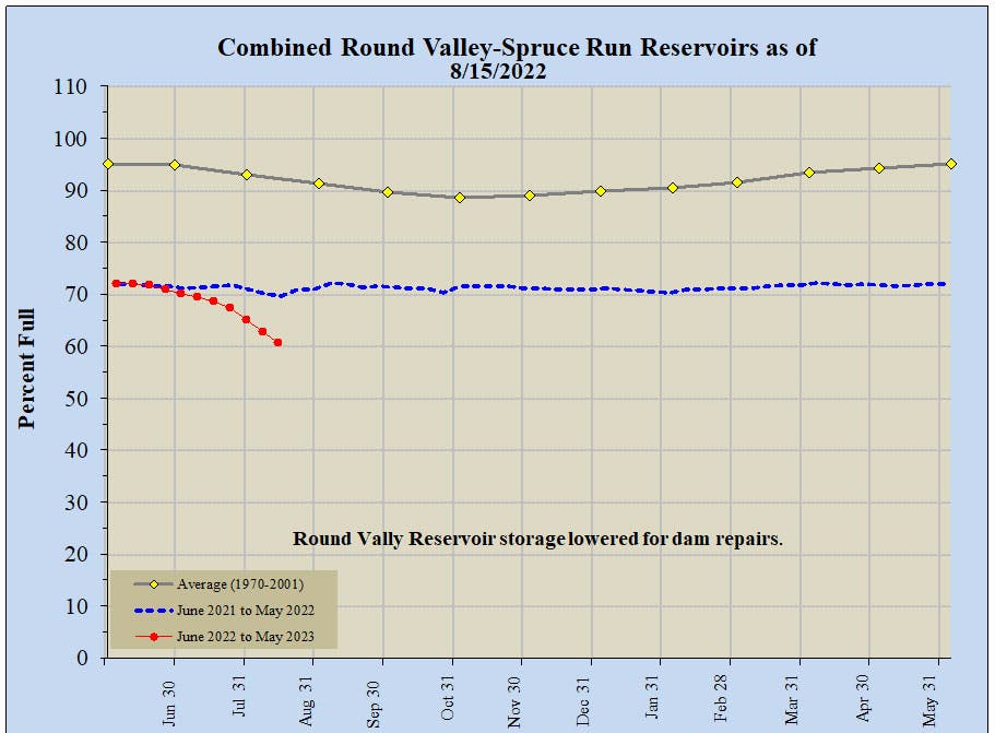
That includes the Round Valley and Spruce Run Reservoirs in Hunterdon County, which were about 60 percent full as of Monday. The reservoirs were about 70 percent full at that time last year and stayed more than 90 percent full during the average summer between 1970 and 2001.
Find out what's happening in Across New Jerseyfor free with the latest updates from Patch.
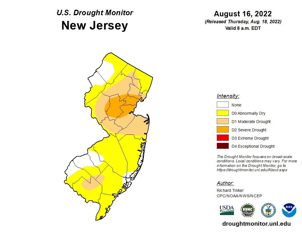
The most recent drought map, released Thursday, shows an expanding portion of New Jersey reaching "severe drought" levels. That typically means poor water quality, declining groundwater, irrigation ponds getting dry and the implementation of outdoor water restrictions, according to the U.S. Drought Monitor.
The "severe drought" area includes Union County, most of Somerset County and potions of Morris, Essex and Hudson Counties.
While stream flow in the area has been strong, the regional precipitation levels have been low for the past three months and the reservoirs have run "severely dry," according to state environmental officials.
New Jersey last declared a drought emergency and restricted water use in March 2002, leaving it in place until January 2003. But the Garden State's climate conditions increase the potential for more frequent and prolonged droughts. New Jersey will experience a greater frequency of intense rain events, and the summer months may see less precipitation overall, according to the 2020 New Jersey Scientific Report on Climate Change.
"While water conservation is always important, it becomes critical during prolonged dry and hot periods like New Jersey has been experiencing," Shawn M. LaTourette, commissioner of the New Jersey Department of Environmental Protection, said after issuing the drought watch. "If residents and businesses do all they can to reduce water demand, together we can ensure ample supplies in the coming weeks and months."
See more info on water conservation.
In the past month, much of New Jersey received less than half of the usual rainfall for this time of year. Cape May County fared worst, with 0.9 inches of rain from July 18 through Tuesday — 3.1 inches below the area's mean rainfall during that timeframe.
.png)
Forecasts show a chance of showers over the weekend and early next week in parts of New Jersey. But that stretch remains too far out for rainfall projections from the National Weather Service.
Here's the National Weather Service's latest North Jersey forecast:
- Thursday: Sunny, with a high near 86. West wind around 7 mph.
- Thursday night: Mostly clear, with a low around 67. West wind around 5 mph becoming calm in the evening.
- Friday: Sunny, with a high near 91. Calm wind becoming southwest 5 to 7 mph in the afternoon.
- Friday night: Partly cloudy, with a low around 72. South wind around 6 mph becoming calm after midnight.
- Saturday: Partly sunny, with a high near 87. Light and variable wind becoming southeast 5 to 10 mph in the morning.
- Saturday night: Mostly cloudy, with a low around 69.
- Sunday: A 30 percent chance of showers after 2 p.m. Partly sunny, with a high near 84.
- Sunday night: A 40 percent chance of showers. Mostly cloudy, with a low around 70.
- Monday: Showers likely, mainly after 2 p.m. Mostly cloudy, with a high near 80. Chance of precipitation is 60 percent.
- Monday night: Showers likely, mainly before 8 p.m. Mostly cloudy, with a low around 70. Chance of precipitation is 60 percent.
- Tuesday: A 40 percent chance of showers. Partly sunny, with a high near 82.
- Tuesday night: Mostly cloudy, with a low around 70.
- Wednesday: A 30 percent chance of showers. Partly sunny, with a high near 84.
Here's the agency's latest South Jersey forecast:
- Thursday: Sunny, with a high near 87. West wind 5 to 10 mph.
- Thursday night: Mostly clear, with a low around 64. Southwest wind around 5 mph becoming calm.
- Friday: Sunny, with a high near 90. Light west wind becoming southwest 5 to 10 mph in the afternoon.
- Friday night: A slight chance of showers after 2 a.m. Mostly cloudy, with a low around 67. South wind around 5 mph becoming calm in the evening. Chance of precipitation is 20 percent.
- Saturday: A chance of showers, mainly after 8 a.m. Mostly cloudy, with a high near 84. Light east wind becoming southeast 5 to 10 mph in the morning. Chance of precipitation is 40 percent. New precipitation amounts of less than a tenth of an inch possible.
- Saturday night: A chance of showers before 2 a.m. Mostly cloudy, with a low around 67. Chance of precipitation is 30 percent. New precipitation amounts of less than a tenth of an inch possible.
- Sunday: A chance of showers after 2 p.m. Patchy fog before 7 a.m., then patchy fog after 9 a.m. Otherwise, partly sunny, with a high near 86. Chance of precipitation is 30 percent.
- Sunday night: A chance of showers. Patchy fog. Otherwise, mostly cloudy, with a low around 67. Chance of precipitation is 50 percent.
- Monday: Showers likely, mainly after 2 p.m. Mostly cloudy, with a high near 83. Chance of precipitation is 70 percent.
- Monday night: Showers likely, mainly before 8 p.m. Mostly cloudy, with a low around 67. Chance of precipitation is 60 percent.
- Tuesday: A chance of showers. Partly sunny, with a high near 84. Chance of precipitation is 40 percent.
- Tuesday night: A chance of showers. Mostly cloudy, with a low around 67. Chance of precipitation is 30 percent.
- Wednesday: Mostly sunny, with a high near 86.
Get more local news delivered straight to your inbox. Sign up for free Patch newsletters and alerts.