Weather
Severe Thunderstorms, Flooding, Tornadoes Threaten NJ In Friday Forecast
The National Weather Service issued a severe-thunderstorm watch Friday afternoon in 13 counties. Here's the latest.

Editor's note: This article was updated at 1:30 p.m. Friday.
NEW JERSEY — The National Weather Service issued a severe-thunderstorm watch Friday afternoon in 13 counties. The storm could bring scattered gusts up to 65 mph, hail up to a half-inch in size, flash flooding and even a couple of isolated tornadoes, the agency says.
The thunderstorm watch began runs until 7 p.m. Friday. The watch affects the following counties: Atlantic, Burlington, Camden, Cape May, Cumberland, Gloucester, Hunterdon, Mercer, Morris, Salem, Somerset, Sussex and Warren.
Find out what's happening in Across New Jerseyfor free with the latest updates from Patch.
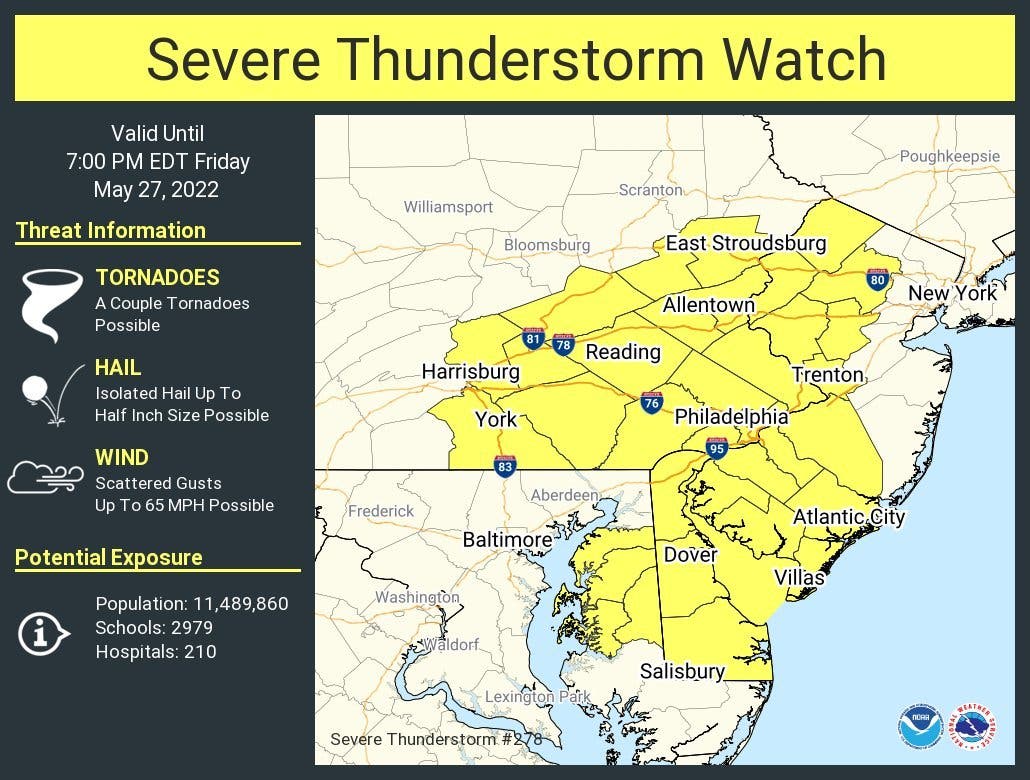
A flood watch remains in effect for Hunterdon, Mercer and Warren Counties through Friday evening. Significant rainfall could impact rivers, creeks, streams and other low-lying and flood-prone locations, the National Weather Service says.
Damaging winds remain New Jersey's primary threat from the storm. Some showers and scattered thunderstorms could linger into Saturday, according to officials. But forecasters don't believe Memorial Day weekend will be a total washout, as Sunday and Monday have sunny forecasts.
Find out what's happening in Across New Jerseyfor free with the latest updates from Patch.
Forecasters anticipate showers and thunderstorms to mainly occur after 3 p.m. when they hit eastern New Jersey.
Here’s the latest forecast, per the National Weather Service:
- Friday afternoon: Showers and thunderstorms, mainly after 3pm. Some storms could be severe, with large hail, damaging winds, and heavy rain. High near 79. South wind 10 to 15 mph, with gusts as high as 25 mph. Chance of precipitation is 80%. New rainfall amounts between a tenth and quarter of an inch, except higher amounts possible in thunderstorms.
- Friday night: Showers and thunderstorms before 5am, then a chance of showers. Some storms could be severe, with gusty winds and heavy rain. Low around 65. South wind 5 to 10 mph. Chance of precipitation is 80%. New rainfall amounts between a quarter and half of an inch possible.
- Saturday: A chance of showers, with thunderstorms also possible after 8am. Cloudy, then gradually becoming mostly sunny, with a high near 78. West wind 5 to 10 mph. Chance of precipitation is 30%. New rainfall amounts of less than a tenth of an inch, except higher amounts possible in thunderstorms.
- Saturday night: Mostly clear, with a low around 59. North wind around 5 mph.
- Sunday: Sunny, with a high near 81. North wind around 5 mph becoming calm.
- Sunday night: Mostly clear, with a low around 63.
- Monday: Sunny, with a high near 91.
- Monday night: Partly cloudy, with a low around 69.
Get more local news delivered straight to your inbox. Sign up for free Patch newsletters and alerts.