Weather
Strong Winds, Showers, Thunderstorm In NJ's Wednesday Forecast
Enjoy Tuesday's calm weather. Some powerful gusts are about to hit the Garden State, according to weather officials.



NEW JERSEY — Enjoy Tuesday's calm weather, and consider securing garbage cans and items that might blow away. Powerful gusts, rain and an isolated thunderstorm could plague New Jersey on Wednesday, according to forecasters.
The National Weather Service doesn't expect much rain to accumulate, so strong winds represent the primary concern for Wednesday's storm. Forecasters expect gusts of 30-40 mph throughout the region in the morning, with stronger winds on the Jersey Shore.
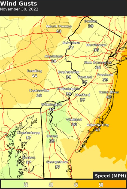
The agency issued a wind advisory for the Shore — Monmouth, Ocean, Atlantic and Cape May Counties — that will run from 10 a.m. to 6 p.m. Wednesday. The coastal counties can expect south winds of 20-30 mph, with gusts up to 45 mph, according to the advisory.
Find out what's happening in Across New Jerseyfor free with the latest updates from Patch.
The powerful winds on the Shore could blow around unsecured objects, knock down tree limbs and cause some power outages. Secure your outdoor belongings, and use extra caution when driving, the advisory states.
Northwestern New Jersey may also get particularly powerful gusts, according to the National Weather Service. The agency is considering issuing a wind advisory for the area, with the heaviest winds likely to favor the highest terrain in the area and in the bordering Pennsylvania region: Berks County and the southern Poconos.
Find out what's happening in Across New Jerseyfor free with the latest updates from Patch.
The National Weather Service issues a wind advisory when forecasters expect sustained winds of 31-39 mph for at least an hour and/or gusts of 46-57 mph for any duration. The agency "held off on a wind advisory in these areas for now, and have forecast maximum wind gusts just below advisory criteria, but will be watching guidance trends closely over the next 24 hours," said the Tuesday morning forecast discussion from the agency's Mount Holly office.
Forecasters expect general rainfall of 0.25 inches to an inch, but locally higher amounts remain possible. Flooding risk remains relatively low because of recent rainfall deficits and the speed at which the system will move through the region, according to the National Weather Service. But localized flooding could still occur.
Winds will gradually subside Wednesday night through Thursday. Gusts of 25-35 mph are possible on Thursday, but drier air will filter in, forecasters say.
Here's the National Weather Service's latest North Jersey forecast:
- Tuesday: Mostly sunny, with a high near 46. Light and variable wind.
- Tuesday night: Increasing clouds, with a low around 38. Light and variable wind.
- Wednesday: Showers, mainly after 10 a.m. High near 59. Breezy, with a south wind 6 to 11 mph increasing to 17 to 22 mph in the afternoon. Winds could gust as high as 43 mph. Chance of precipitation is 100 percent. New precipitation amounts between a half and three-quarters of an inch possible.
- Wednesday night: Mostly cloudy during the early evening, then gradual clearing, with a low around 32. Wind chill values between 25 and 30. West wind 11 to 18 mph, with gusts as high as 37 mph.
- Thursday: Sunny, with a high near 44. West wind 11 to 16 mph, with gusts as high as 28 mph.
- Thursday night: Mostly clear, with a low around 29.
- Friday: Sunny, with a high near 46.
Here's the agency's latest South Jersey forecast:
- Tuesday: Partly sunny, with a high near 49. Northeast wind around 5 mph becoming calm.
- Tuesday night: Mostly cloudy, with a low around 34. Calm wind becoming southeast around 5 mph after midnight.
- Wednesday: Showers, mainly after 10 a.m. High near 60. Breezy, with a south wind 10 to 15 mph increasing to 20 to 25 mph in the afternoon. Winds could gust as high as 35 mph. Chance of precipitation is 100 percent. New precipitation amounts between a half and three-quarters of an inch possible.
- Wednesday night: Showers likely, mainly before 7 p.m. Mostly cloudy during the early evening, then gradual clearing, with a low around 29. Breezy, with a west wind 15 to 20 mph, with gusts as high as 30 mph. Chance of precipitation is 60 percent. New precipitation amounts of less than a tenth of an inch possible.
- Thursday: Sunny, with a high near 42. Breezy, with a west wind 15 to 20 mph.
- Thursday night: Mostly clear, with a low around 24.
- Friday: Sunny, with a high near 47.
Get more local news delivered straight to your inbox. Sign up for free Patch newsletters and alerts.