Weather
Returning Storms To Bring Heavy Rain, Flooding To PA: See Forecast
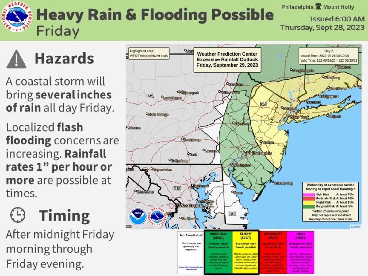
The coastal storm will bring dreary conditions and potential flash flooding in certain areas throughout the day Friday, said forecasters.

PENNSYLVANIA — Prepare your umbrellas and brace for more potential flooding in the Philadelphia metro area beginning Friday, as forecasters say the former Tropical Storm Ophelia will again bring dreary conditions to the region.
The coastal storm will bring several inches of rain throughout the day Friday along the East Coast, said the National Weather Service. Rainfall rates of 1 inch per hour or more are possible at times, forecasters said.
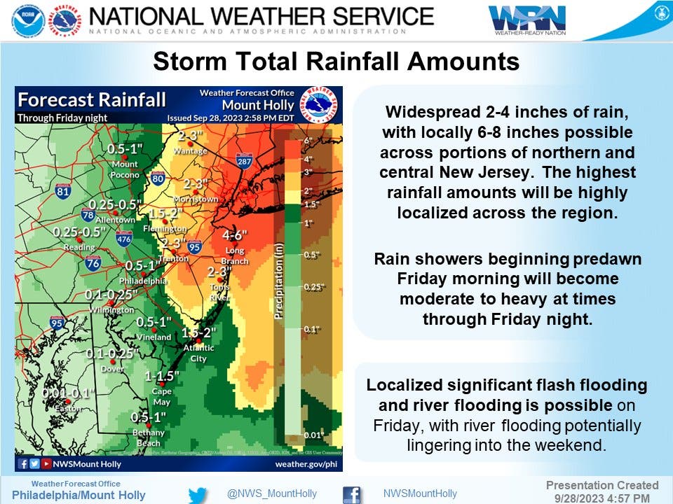
In the Philadelphia region, forecasters are predicting between half an inch and 1 inch of rain as of the latest update; showers may be heavy as they move through the region, but look to be affecting neighboring New Jersey more.
Find out what's happening in Across New Jerseyfor free with the latest updates from Patch.
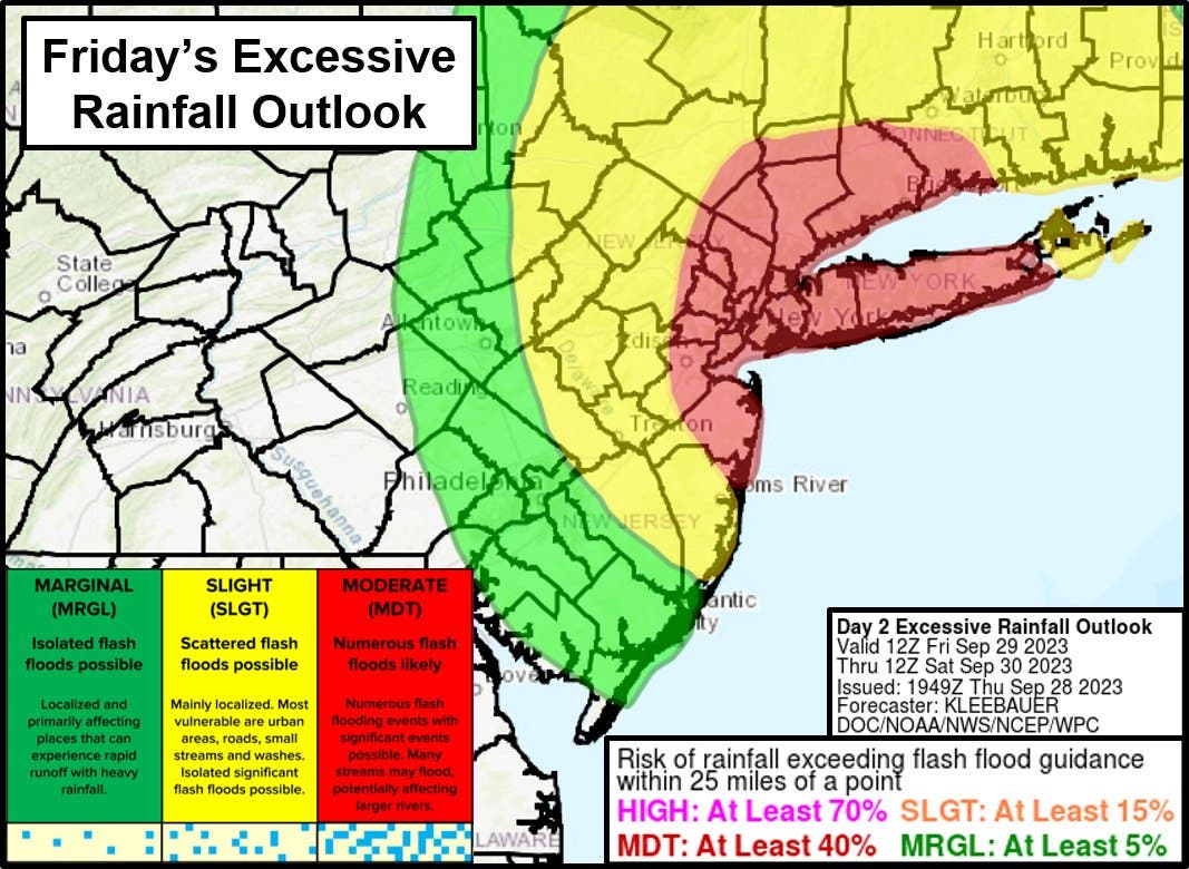
There is a marginal risk for excessive rainfall in most of southeast Pennsylvania, meaning isolated flash flooding is possible, primarily affecting places that "can experience rapid runoff with heavy rainfall."
The region is under a hazardous weather outlook for potential flooding, with coastal flood advisories in Delaware, Lower Bucks, and Philadelphia counties until Friday morning.
Find out what's happening in Across New Jerseyfor free with the latest updates from Patch.
"Residents and visitors are advised to remain weather aware and never drive through flooded roadways," said the Storm Prediction Center in their forecast discussion.
Click here to view all National Weather Service advisories in Pennsylvania.
Ophelia is expected to head northeastward Thursday night, and spread rain back in the region Friday - especially in coastal areas of the United States. Thunderstorms and rain showers will develop around the region overnight Thursday into Friday morning, forecasters said.
Rain showers are expected to begin in the pre-dawn hours Friday morning and will become "moderate to heavy at times through Friday night." River flooding concerns could linger into the weekend, the NWS added.
The showers and storms are expected to taper off Friday night.
“This system will move east of the area slowly on Saturday, with high pressure regaining full control Sunday into early next week,” the NWS said.
Here is a look at the forecast through Friday in southeastern Pennsylvania from the National Weather Service:
Thursday Night: A chance of showers before 11pm, then a chance of showers and thunderstorms between 11pm and 2am, then showers likely and possibly a thunderstorm after 2am. Mostly cloudy, with a low around 57. Northeast wind around 10 mph. Chance of precipitation is 70 percent. New rainfall amounts between a quarter and half of an inch possible.
Friday: Showers likely and possibly a thunderstorm. Mostly cloudy, with a high near 64. Northeast wind 10 to 15 mph. Chance of precipitation is 70 percent. New rainfall amounts between a half and three quarters of an inch possible.
Friday Night: A chance of showers. Cloudy, with a low around 57. Northeast wind around 10 mph. Chance of precipitation is 40 percent. New precipitation amounts between a tenth and quarter of an inch possible.
Get more local news delivered straight to your inbox. Sign up for free Patch newsletters and alerts.


