Weather
Snow Map Released For Weekend Storm Headed To NJ
A coastal storm is expected to head north, packing strong winds and coastal flooding along with snow.

A fierce winter storm that's expected to pummel southern states may or may not bring significant snow to New Jersey over the weekend, with forecasters saying the difference in the outcome amounting to just a few miles on the storm track.
The National Weather Service Mount Holly office said New Jersey has a 40 to 50 percent chance of seeing at least 4 inches of snow, with forecasters saying the totals will be higher near the coast.
Accuweather, which called the storm a bomb cyclone, said there are 3 to 6 inches of snow in store for coastal areas of New Jersey, with the bigger snow impacts of the storm expected in North Carolina and New England.
Find out what's happening in Across New Jerseyfor free with the latest updates from Patch.

"What we know: The highest snow totals will be along the coast, if any," the Mount Holly office said. "There is increasing potential for strong N to NE winds, and potential for significant coastal flooding on Sunday. What we don't know: Exact snowfall amounts and timing. Snow accumulations could extend inland to the I-95 corridor and beyond, remain confined near the coast, or snow could stay mostly offshore."
The National Weather Service Weather Prediction Center also said snow possibilities have "greater uncertainty farther up the coast" with the exception of southeast New England.
Find out what's happening in Across New Jerseyfor free with the latest updates from Patch.
The storm will produce powerful onshore winds, with gusts of near hurricane force in some areas, the Weather Prediction Center said.
The combination of the wind and astronomical high tides from the full moon will make for coastal flooding of 2 to 3 feet, in the moderate range, forecasters said.

Meteorologist Dan Zarrow of NJ 101.5 said the top gusts in New Jersey are expected to be around 50 mph and tidal flooding will be a concern for two to three high tide cycles.
"It's not the storm we thought it could become earlier in the week," Zarrow said, "but it's not nothing either."
Zarrow said the majority of the storm models are indicating the storm will shift out to sea as it passes New Jersey, but said there is "a reasonable chance that light accumulating snow develops from late Saturday into Sunday."
Three days out, the storm track is still very uncertain, he said.
Noreaster Nick said the difference between some snow and none at all is a matter of miles.
"Sure, we've got a massive storm offshore but it should stay mostly east," he said, adding that he estimates 30 miles is the difference between flurries and 3 inches of snow or more.
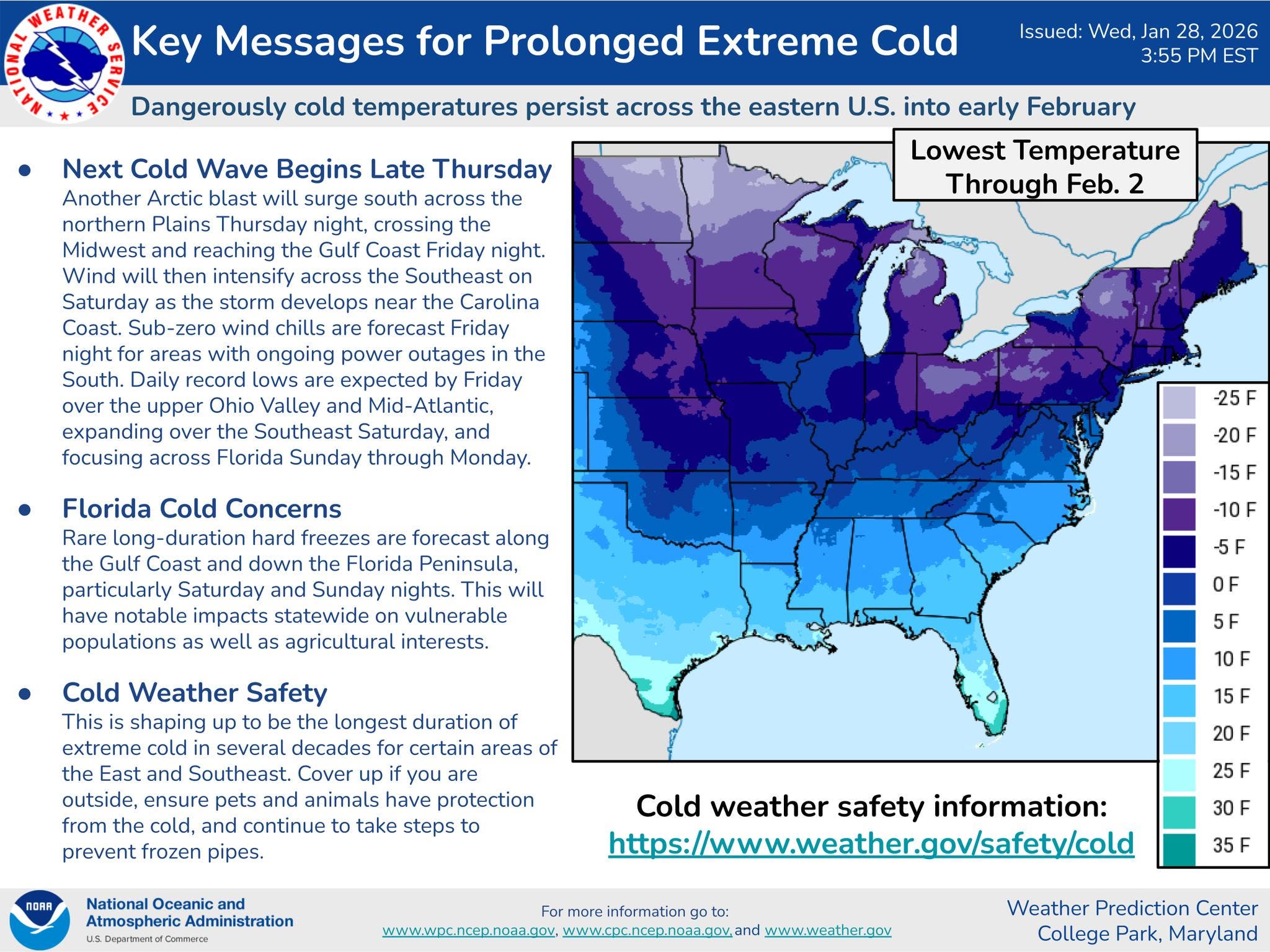
In the meantime, keep bundling up. Dangerously cold temperatures are expected to continue through the weekend with another round of near or below-zero lows starting Friday.
Get more local news delivered straight to your inbox. Sign up for free Patch newsletters and alerts.