Weather
Snow, Wind, Rain Continue Tuesday In NJ: See Nor'Easter Timeline
The main concern Tuesday will be strong winds, which could blow down trees and cause power outages -- but snow is still falling, too.


NEW JERSEY — Wet weather will turn windy as the latest winter storm moves into New Jersey, bringing a risk of power outages and downed trees Tuesday into Wednesday.
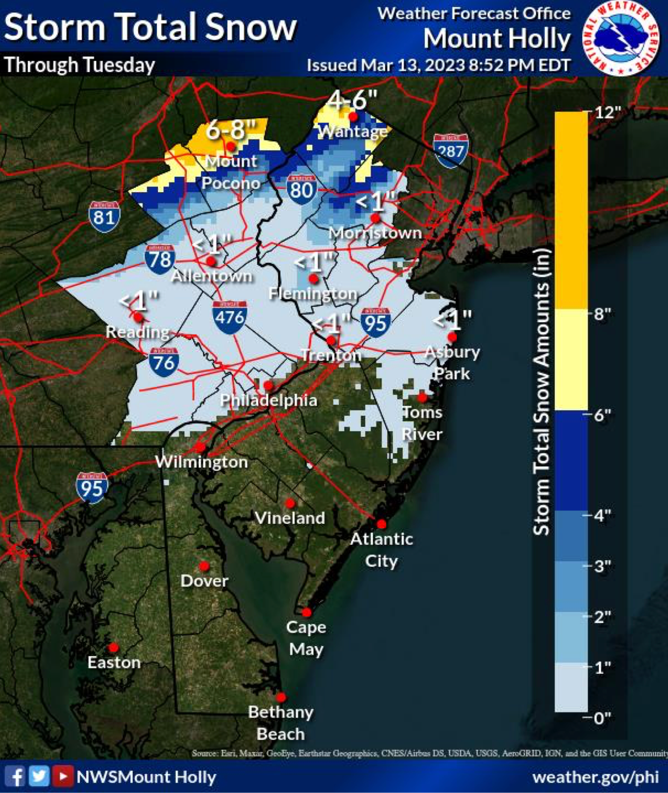
Snow totals have lowered around North Jersey, where five counties were placed under a state of emergency Monday night, but there’s still a chance residents of these counties will see enough snow to make travel difficult.
The storm has caused flight delays and cancellations at both LaGuardia and Newark airports, according to FlightAware.
Find out what's happening in Across New Jerseyfor free with the latest updates from Patch.

Forecasters are still calling for up to 10 inches total along the I-80 corridor by the end of the day Tuesday, and about two inches in portions of the I-78 corridor.
Sussex County is still under a winter storm warning until 6 p.m. Tuesday evening with four to eight inches of snow expected, and more at higher elevations; Warren and Morris counties have dropped to a winter weather advisory.
Find out what's happening in Across New Jerseyfor free with the latest updates from Patch.
Some snow showers are still possible in the Philadelphia metro area and parts of southern New Jersey on Tuesday, according to the National Weather Service.
The main concern Tuesday into Wednesday will be strong winds, which could blow down trees and cause power outages, said AccuWeather. Northwest winds will be about 20-30 miles per hour, but gusts of 40-50 miles per hour are possible across the state.
A wind advisory is in effect for central and southern New Jersey.
By this afternoon, according to the NWS, “These winds will help wrap in colder air behind the storm, especially aloft, meaning wrap around precip should become mainly snow/snow showers except near the coast. That said, south of the I-78 corridor the fact that the precip will be light and surface temperatures above freezing will limit any snow accumulation to at most a coating to half inch."
Gale force winds with gusts of 35-45 knots on the NJ/DE Atlantic Coast and the Delaware Bay are expected Tuesday into Wednesday, added the NWS. Coastal flooding will also be a concern, AccuWeather forecasters say, with a coastal flood advisory issued.
Here is a look at the forecast around New Jersey:
North Jersey
Today
Snow. High near 36. Wind chill values between 25 and 30. West wind 15 to 17 mph, with gusts as high as 33 mph. Chance of precipitation is 90%. Total daytime snow accumulation of 1 to 3 inches possible.
Tonight
Snow likely before 8pm, then a chance of snow showers between 8pm and 2am. Cloudy, with a low around 32. Wind chill values between 20 and 25. Windy, with a northwest wind 24 to 26 mph, with gusts as high as 37 mph. Chance of precipitation is 60%. New snow accumulation of less than a half inch possible.
Wednesday
Mostly cloudy, then gradually becoming sunny, with a high near 43. Wind chill values between 20 and 30. Windy, with a northwest wind 26 to 28 mph, with gusts as high as 41 mph.
Wednesday Night
Mostly clear, with a low around 30. Wind chill values between 20 and 25. Blustery, with a northwest wind 14 to 22 mph, with gusts as high as 34 mph.
Central Jersey
Today
Snow likely, mainly between 11am and 2pm. Cloudy, with a high near 38. Breezy, with a west wind 20 to 25 mph, with gusts as high as 45 mph. Chance of precipitation is 70%. Little or no snow accumulation expected.
Tonight
A chance of snow, mainly before 8pm. Mostly cloudy, with a low around 30. Blustery, with a northwest wind 20 to 25 mph, with gusts as high as 45 mph. Chance of precipitation is 30%. Little or no snow accumulation expected.
Wednesday
Mostly cloudy, then gradually becoming sunny, with a high near 47. Breezy, with a northwest wind 20 to 25 mph, with gusts as high as 35 mph.
Wednesday Night
Mostly clear, with a low around 28. Northwest wind 10 to 15 mph, with gusts as high as 25 mph.
South Jersey
Today
A slight chance of snow before 11am, then a chance of rain and snow. Mostly cloudy, with a high near 41. Windy, with a west wind 20 to 30 mph, with gusts as high as 50 mph. Chance of precipitation is 30%. Little or no snow accumulation expected.
Tonight
A slight chance of snow before 10pm. Mostly cloudy, with a low around 32. Windy, with a northwest wind 25 to 30 mph, with gusts as high as 45 mph. Chance of precipitation is 20%.
Wednesday
Partly sunny, then gradually becoming sunny, with a high near 49. Breezy, with a northwest wind around 25 mph, with gusts as high as 40 mph.
Wednesday Night
Clear, with a low around 33. Breezy, with a northwest wind 15 to 20 mph, with gusts as high as 30 mph.
Get more local news delivered straight to your inbox. Sign up for free Patch newsletters and alerts.