Weather
Storms, Then Big Weather Shift Ahead For NJ
Severe storms with damaging wind gusts and the coldest day in months are likely to follow a new front.


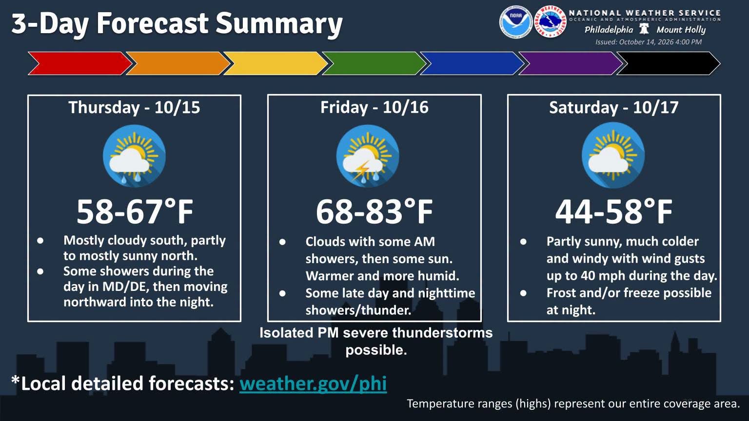
Severe thunderstorms with damaging winds are possible Friday ahead of a massive temperature drop, according to the latest forecast.
Temperatures will rise to the upper-70s and low-80s Friday before a strong cold front moves into New Jersey Friday evening into the night, National Weather Service forecasters said.
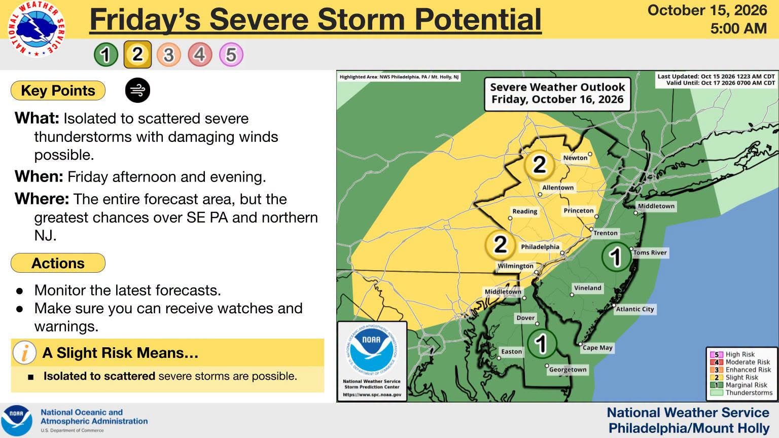
"Scattered to widespread showers and some storms are likely to form along and immediately ahead of the cold front," the National Weather Service said. "It remains a possibility that a few storms could become severe, with damaging wind gusts being the primary hazard."
Find out what's happening in Across New Jerseyfor free with the latest updates from Patch.
Most of the Garden State is under a marginal risk for severe storms, one out of five, with part of the state under a slight risk, two out of five.
Showers and storms will clear up from west to east Friday night.
Find out what's happening in Across New Jerseyfor free with the latest updates from Patch.
Breezy winds will linger overnight Friday through much of the day Saturday.
Wind gusts of 30 mph to 40 mph are possible. Forecasters are not ruling out stronger gusts as well.
Temperatures are set to plummet Saturday. National Weather Service forecasters said that a "fairly widespread frost" is expected across most of New Jersey.
Lows in the mid-30s to near 40 are expected Friday night, with parts of North Jersey dropping below freezing, according to the National Weather Service. Rural parts of South Jersey could even see the year's first freeze.
Here's the latest forecast.
North Jersey
Thursday: Mostly sunny, with a high near 63. East wind around 5 mph.
Thursday Night: Showers, mainly after midnight. Low around 52. Southeast wind around 5 mph. Chance of precipitation is 80 percent. New precipitation amounts of less than a tenth of an inch possible.
Friday: Showers likely before 10 a.m., then showers likely and possibly a thunderstorm after 5 p.m. Cloudy, then gradually becoming mostly sunny, with a high near 75. Southwest wind 5 to 10 mph, with gusts as high as 20 mph. Chance of precipitation is 60 percent. New rainfall amounts between a tenth and quarter of an inch, except higher amounts possible in thunderstorms.
Friday Night: Showers and thunderstorms before 11 p.m., then a chance of showers. Low around 45. West wind 10 to 15 mph becoming northwest after midnight. Chance of precipitation is 80 percent. New precipitation amounts between a tenth and quarter of an inch, except higher amounts possible in thunderstorms.
Saturday: Mostly sunny, with a high near 51. North wind around 15 mph, with gusts as high as 30 mph.
Saturday Night: Areas of frost. Otherwise, mostly clear, with a low around 35.
Sunday: Areas of frost before 10 a.m. Otherwise, sunny, with a high near 55.
Sunday Night: Mostly clear, with a low around 38.
Monday: Sunny, with a high near 60.
Central Jersey
Thursday: Mostly sunny, with a high near 64. East wind 5 to 10 mph.
Thursday Night: Showers, mainly after midnight. Low around 54. percent. New precipitation amounts of less than a tenth of an inch possible.
Friday: Showers likely, mainly before 9 a.m. Cloudy through mid morning, then gradual clearing, with a high near 79. Southwest wind around 10 mph, with gusts as high as 20 mph. Chance of precipitation is 60 percent. New precipitation amounts of less than a tenth of an inch possible.
Friday Night: Showers and thunderstorms. Low around 46. West wind 10 to 15 mph becoming northwest after midnight. Chance of precipitation is 80 percent. New precipitation amounts between a quarter and half of an inch possible.
Saturday: A chance of showers before 8 a.m. Partly sunny, with a high near 53. Breezy, with a north wind 15 to 20 mph. Chance of precipitation is 30 percent. New precipitation amounts of less than a tenth of an inch possible.
Saturday Night: Patchy frost. Otherwise, mostly clear, with a low around 36.
Sunday: Patchy frost before 10 a.m. Otherwise, sunny, with a high near 56.
Sunday Night: Mostly clear, with a low around 39.
Monday: Mostly sunny, with a high near 62.
South Jersey
Thursday: Increasing clouds, with a high near 66. East wind around 5 mph.
Thursday Night: Showers likely, mainly after 4 a.m. Mostly cloudy, with a low around 56. East wind around 5 mph. Chance of precipitation is 60 percent. New precipitation amounts of less than a tenth of an inch possible.
Friday: A chance of showers before 8 a.m. Cloudy through mid morning, then gradual clearing, with a high near 79. Southwest wind 5 to 10 mph, with gusts as high as 20 mph. Chance of precipitation is 30 percent. New precipitation amounts of less than a tenth of an inch possible.
Friday Night: Showers and possibly a thunderstorm. Low around 47. Southwest wind 10 to 15 mph becoming northwest after midnight. Chance of precipitation is 90 percent. New precipitation amounts between a tenth and quarter of an inch, except higher amounts possible in thunderstorms.
Saturday: Showers likely before 8 a.m. Partly sunny, with a high near 54. North wind around 15 mph, with gusts as high as 25 mph. Chance of precipitation is 60 percent. New precipitation amounts of less than a tenth of an inch possible.
Saturday Night: Patchy frost. Otherwise, mostly clear, with a low around 36.
Sunday: Patchy frost before 10 a.m. Otherwise, sunny, with a high near 58.
Sunday Night: Mostly clear, with a low around 40.
Monday: Sunny, with a high near 62.
Get more local news delivered straight to your inbox. Sign up for free Patch newsletters and alerts.