Weather
Subtropical Storm Josephine Moves Away From NJ: Latest Forecast
While it will still be a bit breezy on Thursday, forecasters expect it to be noticeably less windy along the coast as Josephine moves away.




New Jersey is in for a breezy fall weekend as Subtropical Storm Josephine moves away from the Garden State.
According to the latest forecast from the National Weather Service, the off-coast nor'easter that was declared a subtropical storm on Wednesday is expected to stay away from New Jersey.
While it will still be a bit breezy on Thursday, forecasters expect it to be notably less windy along the coast as Josephine moves away.
Find out what's happening in Across New Jerseyfor free with the latest updates from Patch.
There will be some minor tidal flooding during high tide, but the weather will otherwise remain seasonable.
Cooler air is expected to arrive for the start of the weekend with more frost potential.
Find out what's happening in Across New Jerseyfor free with the latest updates from Patch.
"A tight pressure gradient will persist through today between high pressure over the Northeast and the well offshore Subtropical Storm Josephine," the weather service said.
"Breezy conditions will continue, but coastal areas will be less windy than recent days."
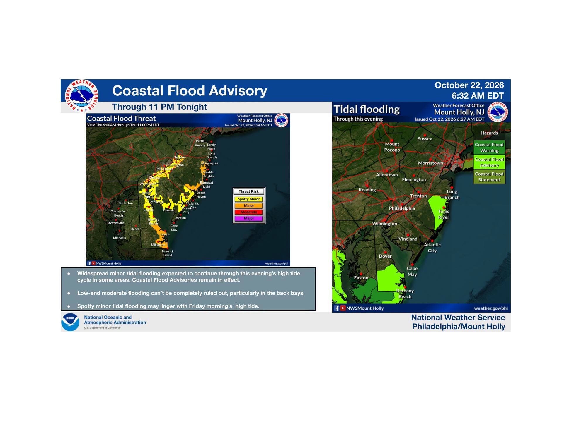
As Josephine departs on Thursday, gusty northerly winds will continue with the highest wind gusts reaching 20-30 MPH.
Besides strong winds, it will be mostly sunny and seasonable temperatures before turning a bit colder over the next few days.
Here's the latest forecast from the National Weather Service:
NORTH JERSEY
- Thursday: Sunny, with a high near 66. North wind around 10 MPH, with gusts as high as 22 MPH.
- Thursday Night: Clear, with a low around 44. North wind 5-11 MPH, with gusts as high as 21 MPH.
- Friday: Sunny, with a high near 59. North wind 6-9 MPH.
- Friday Night: Mostly clear, with a low around 39. Light north wind.
- Saturday: Sunny, with a high near 61. North wind around 5 MPH, becoming calm in the morning.
- Saturday Night: Clear, with a low around 40.
- Sunday: Sunny, with a high near 64.
- Sunday Night: Clear, with a low around 43.
CENTRAL JERSEY
- Thursday: Sunny, with a high near 66. North wind 10-15 MPH, with gusts as high as 25 MPH.
- Thursday Night: Mostly clear, with a low around 41. North wind 5-15 MPH, with gusts as high as 25 MPH.
- Friday: Sunny, with a high near 58. Northeast wind 5-10 MPH, with gusts as high as 20 MPH.
- Friday Night: Patchy frost after midnight. Otherwise, partly cloudy, with a low around 36. East wind around 5 MPH becoming north after midnight.
- Saturday: Areas of frost before 9 a.m. Otherwise, mostly sunny, with a high near 60. North wind around 5 MPH becoming calm in the morning.
- Saturday Night: Patchy frost after 1 a.m. Otherwise, mostly clear, with a low around 36.
- Sunday: Areas of frost before 9 a.m. Otherwise, sunny, with a high near 64.
- Sunday Night: Mostly clear, with a low around 38.
SOUTH JERSEY
- Thursday: Sunny, with a high near 63. North wind around 15 MPH.
- Thursday Night: Mostly clear, with a low around 45. North wind 10-15 MPH.
- Friday: Sunny, with a high near 56. Northeast wind around 15 MPH.
- Friday Night: Mostly clear, with a low around 44. Northeast wind 10-15 MPH.
- Saturday: Mostly sunny, with a high near 57. Northeast wind 5-10 MPH.
- Saturday Night: Mostly clear, with a low around 45.
- Sunday: Sunny, with a high near 58.
- Sunday Night: Clear, with a low around 48.
Get more local news delivered straight to your inbox. Sign up for free Patch newsletters and alerts.