Weather
Tornadoes, Flooding Threaten NJ As Tropical Storm Debby Moves In
Tropical Storm Debby is heading north and is expected to hit New Jersey Thursday, bringing severe storm, tornadoes and lots of rain:

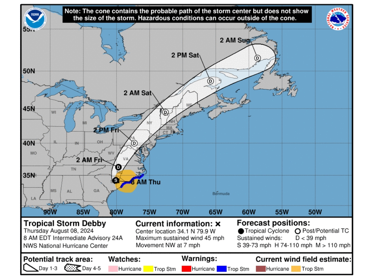
NEW JERSEY — Tornadoes, flash flooding and several inches of rain are all possible for the Garden State as Tropical Storm Debby heads to New Jersey.
The first rain bands of the storm will hit New Jersey Thursday, according to the National Weather Service, but Friday is the primary concern.
"In general, rain bands today should be fast moving enough (and limited in coverage) to limit the flooding threat," National Weather Service forecasters said in their Thursday briefing. "That being said, the later half of the day, the environment will increasingly have similarities to a tropical environment, with high precipitable water values and very deep warm cloud layers, so localized flash flooding is possible."
Find out what's happening in Across New Jerseyfor free with the latest updates from Patch.
On Friday, the entire state is at risk for severe thunderstorms with possible tornadoes into Friday night, according to the forecast. As Debby is tracking more inward, this places the state "in the more favorable zone for the tornado risk," the National Weather Service said.
Even without tornados, though, it'll be windy: winds will likely be 15 to 25 mph with gusts at least 30 to 40 mph, forecasters say. The shore may see winds up to 50 mph, with dangerous rip currents in the water.
Find out what's happening in Across New Jerseyfor free with the latest updates from Patch.
"The combination of tropical-storm-force winds will have trees bobbing and tipping in the saturated soil, and a number may topple over that can lead to property damage and power outages," AccuWeather Meteorologist Brandon Buckingham said.
There are also concerns for main stem river flooding and some minor tidal flooding, and of course flash flooding across the state.
The good news is that as Debby leaves, it'll usher in a period of drier and cooler weather with lower humidity, according to the forecast.
Here's the latest forecast.
North Jersey
Thursday: Showers likely, mainly before 2pm. Cloudy, with a high near 73. East wind around 10 mph, with gusts as high as 20 mph. Chance of precipitation is 60%. New precipitation amounts between a tenth and quarter of an inch possible.
Thursday Night: A chance of showers, then showers likely and possibly a thunderstorm after 2am. Cloudy, with a low around 70. East wind 6 to 9 mph. Chance of precipitation is 70%. New rainfall amounts between a tenth and quarter of an inch, except higher amounts possible in thunderstorms.
Friday: Showers likely and possibly a thunderstorm before 11am, then a chance of showers and thunderstorms between 11am and 4pm, then showers likely and possibly a thunderstorm after 4pm. Cloudy, with a high near 83. Breezy, with a southeast wind 10 to 20 mph, with gusts as high as 33 mph. Chance of precipitation is 70%. New rainfall amounts between a quarter and half of an inch possible.
Friday Night: Showers and possibly a thunderstorm before 2am, then a chance of showers and thunderstorms after 2am. Low around 74. Breezy, with a south wind 17 to 22 mph, with gusts as high as 37 mph. Chance of precipitation is 90%. New rainfall amounts between a half and three quarters of an inch possible.
Saturday: A 30 percent chance of showers and thunderstorms before 8am. Mostly sunny, with a high near 85. West wind 10 to 14 mph.
Saturday Night: Mostly clear, with a low around 66.
Sunday: Mostly sunny, with a high near 82.
Sunday Night: Mostly clear, with a low around 66.
Central Jersey
Thursday: Showers and thunderstorms likely, mainly before 1pm, then showers likely and possibly a thunderstorm after 4pm. Mostly cloudy, with a high near 77. East wind around 10 mph. Chance of precipitation is 60%. New rainfall amounts between a quarter and half of an inch possible.
Thursday Night: Showers likely and possibly a thunderstorm before 7pm, then scattered showers and thunderstorms between 7pm and 4am, then showers likely and possibly a thunderstorm after 4am. Cloudy, with a low around 71. East wind 5 to 10 mph. Chance of precipitation is 60%. New rainfall amounts between a tenth and quarter of an inch, except higher amounts possible in thunderstorms.
Friday: Showers and possibly a thunderstorm. Some of the storms could produce heavy rainfall. High near 83. Breezy, with a south wind 15 to 20 mph, with gusts as high as 30 mph. Chance of precipitation is 80%. New rainfall amounts between a quarter and half of an inch possible.
Friday Night: Showers and possibly a thunderstorm before 2am, then a chance of showers and thunderstorms after 2am. Low around 71. Breezy, with a south wind 15 to 20 mph. Chance of precipitation is 80%. New rainfall amounts between a quarter and half of an inch possible.
Saturday: A chance of showers before 8am. Sunny, with a high near 85. West wind 10 to 15 mph. Chance of precipitation is 30%. New precipitation amounts of less than a tenth of an inch possible.
Saturday Night: Mostly clear, with a low around 61.
Sunday: Sunny, with a high near 82.
Sunday Night: Mostly clear, with a low around 61.
South Jersey
Thursday: Scattered showers and thunderstorms before 11am, then showers likely and possibly a thunderstorm between 11am and 1pm, then scattered showers and thunderstorms after 1pm. Mostly cloudy, with a high near 79. East wind around 10 mph. Chance of precipitation is 60%. New rainfall amounts between a quarter and half of an inch possible.
Thursday Night: Scattered showers and thunderstorms, then showers likely and possibly a thunderstorm after 5am. Mostly cloudy, with a low around 72. Southeast wind 5 to 10 mph, with gusts as high as 20 mph. Chance of precipitation is 60%. New rainfall amounts between a tenth and quarter of an inch, except higher amounts possible in thunderstorms.
Friday: Showers likely and possibly a thunderstorm. Some of the storms could produce heavy rainfall. Mostly cloudy, with a high near 82. Breezy, with a south wind 15 to 20 mph, with gusts as high as 40 mph. Chance of precipitation is 70%. New rainfall amounts between a quarter and half of an inch possible.
Friday Night: Showers and possibly a thunderstorm before 2am, then a chance of showers and thunderstorms after 2am. Low around 71. South wind around 15 mph, with gusts as high as 30 mph. Chance of precipitation is 80%. New rainfall amounts between a quarter and half of an inch possible.
Saturday: A chance of showers before 8am. Sunny, with a high near 85. West wind around 10 mph, with gusts as high as 20 mph. Chance of precipitation is 30%. New precipitation amounts of less than a tenth of an inch possible.
Saturday Night: Mostly clear, with a low around 62.
Sunday: Mostly sunny, with a high near 82.
Sunday Night: Mostly clear, with a low around 61.
Get more local news delivered straight to your inbox. Sign up for free Patch newsletters and alerts.