Weather
Storm Headed To NJ: Snow, Ice Possible In Some Areas
Some areas of the state may see more snow and ice, while others will have rain and wind gusts up to 45 miles per hour, forecasters said.


NEW JERSEY — A major storm may bring snow and ice to parts of New Jersey on Friday, and will potentially cause flooding and high winds in other areas, forecasters said.
Forecasters say the timing and effect of the storm across NJ depends on how air masses and areas of high and low pressure interact.
"The storm system will be a complex one where one center of low pressure will track northeastward into the Midwest and weaken from Thursday night to Friday before a secondary low pressure area forms along the mid-Atlantic coast and heads northeastward over the ocean on Friday," said AccuWeather Chief On-Air Meteorologist Bernie Rayno.
Find out what's happening in Across New Jerseyfor free with the latest updates from Patch.
.jpg)
Related article —When It Will Feel Like Spring In NJ: Farmers’ Almanac Outlook
An atmospheric traffic jam, or "Greenland block," has developed in the Northeast but AccuWeather Senior Meteorologist Joe Lundberg said it is not strong enough to really hold the cold air.
Find out what's happening in Across New Jerseyfor free with the latest updates from Patch.
"This first allows the Midwest storm to pull warm air well to the north, not only in the Midwest but also in the Northeast. So there should be a much better chance of a change to rain or a wintry mix from much of Pennsylvania to the lower Hudson Valley of New York and across southern New England," he said.
Changes in the storm's momentum or strength could affect the forecast later this week. Some precipitation will linger Saturday in parts of the state, said forecasters.
Expect windy weather through most of the state Friday regardless of the type of precipitation that falls, forecasters say.
AccuWeather says 1-2 inches of snow are possible in New Jersey's northwestern counties, and the National Weather Service shows more than 2 inches of snow possible in Sussex County and western Passaic County.
Areas in the New York City metro might get enough precipitation "for roads to become slippery." If the storm ramps up quickly, it could bring several inches of snow in the NYC area, forecasters said.
The National Weather Service's New York City office predicts a wintry mix in interior northeastern New Jersey, and said snow and sleet amounts "remain a bit uncertain." Gusts 35-40 mph are possible, especially near the coast.

AccuWeather forecasters predict that some parts of central New Jersey will get some snow and ice on Friday, and heavy rain is expected in parts of the south and along the Shore, with the potential for moderate coastal flooding.
Much of the South Jersey area may not see any precipitation until Friday afternoon or the early evening, said NWS forecasters. Friday evening into overnight is when the heaviest precipitation is expected.
"This is generally not a favorably track for wintry precip for the urban corridor but we still expect there will be some snow and ice with this system farther north towards the I-78 and especially the I-80 corridor," said the NWS's Mount Holly office.
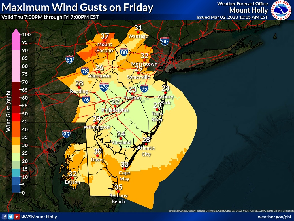
Strong winds, up to 45 miles per hour, and localized freshwater flooding are possible near the coastal areas, with up to 1.5 inches of rain possible in the coastal plain.
Far South Jersey may see up to an inch of rain, the NWS predicted.
Next week, Lundberg said, the Greenland block will be stronger and force a colder flow of air from the northwest over much of the eastern United States.
Here is a look at the extended forecast around New Jersey from the National Weather Service.
In North Jersey
Thursday
Mostly sunny, with a high near 54. Northwest wind 6 to 14 mph, with gusts as high as 24 mph.
Thursday night
Partly cloudy, with a low around 31. Northwest wind 6 to 13 mph.
Friday
A 40 percent chance of rain after 1pm. Increasing clouds, with a high near 44. Northwest wind 5 to 9 mph becoming east in the afternoon.
Friday night
Rain, snow, and sleet, becoming all rain after 10pm. Steady temperature around 39. Breezy, with an east wind 11 to 21 mph, with gusts as high as 31 mph. Chance of precipitation is 100%. Little or no snow and sleet accumulation expected.
Saturday
Rain likely, mainly before 1pm. Mostly cloudy, with a high near 46. Northeast wind 10 to 14 mph becoming northwest in the afternoon. Chance of precipitation is 60%. New precipitation amounts between a tenth and quarter of an inch possible.
In Central Jersey
Thursday
Partly sunny, with a high near 61. Northwest wind 10 to 15 mph, with gusts as high as 25 mph.
Thursday night
Partly cloudy, with a low around 31. Northwest wind 10 to 15 mph decreasing to 5 to 10 mph after midnight.
Friday
Rain likely after 1pm. Increasing clouds, with a high near 44. North wind 5 to 10 mph becoming east in the afternoon. Chance of precipitation is 60%. New precipitation amounts of less than a tenth of an inch possible.
Friday night
Rain before 10pm, then rain and possibly a thunderstorm between 10pm and 4am, then rain after 4am. Low around 38. Breezy, with an east wind 15 to 20 mph becoming northeast after midnight. Winds could gust as high as 30 mph. Chance of precipitation is 100%. New rainfall amounts between 1 and 2 inches possible.
Saturday
A chance of rain before 1pm. Mostly cloudy, with a high near 51. Northwest wind 10 to 15 mph, with gusts as high as 25 mph. Chance of precipitation is 40%. New precipitation amounts of less than a tenth of an inch possible.
In South Jersey
Thursday
Partly sunny, with a high near 60. Northwest wind 10 to 15 mph.
Thursday night
Partly cloudy, with a low around 37. North wind around 10 mph.
Friday
Rain likely after 1pm. Cloudy, with a high near 45. North wind 10 to 15 mph becoming east in the afternoon. Chance of precipitation is 60%. New precipitation amounts of less than a tenth of an inch possible.
Friday night
Rain before 10pm, then rain and possibly a thunderstorm between 10pm and 4am, then rain after 4am. Low around 43. Windy, with an east wind 20 to 30 mph becoming southwest after midnight. Winds could gust as high as 45 mph. Chance of precipitation is 100%. New rainfall amounts between a half and three quarters of an inch possible.
Saturday
A slight chance of rain before 1pm. Partly sunny, with a high near 54. Breezy, with a west wind 15 to 20 mph, with gusts as high as 30 mph. Chance of precipitation is 20%.
Get more local news delivered straight to your inbox. Sign up for free Patch newsletters and alerts.