Weather
Weekend Storm Could Bring Rain, Coastal Flooding To NJ: Latest Forecast
While the storm's exact track and intensity are uncertain, the storm could bring strong winds and heavy rainfall Sunday into Monday.


A late weekend storm could bring strong winds, heavy rainfall and coastal flooding to parts of New Jersey on Sunday.
According to the latest forecast from the National Weather Service, a storm is likely to affect parts of the area Sunday into Monday.
While the storm's exact track and intensity remain uncertain at this time, forecasters expect it to track close enough to the area to bring at least some rainfall to those on the coast.
Find out what's happening in Across New Jerseyfor free with the latest updates from Patch.
"A coastal low is expected to develop off the Southeast coast over the weekend and then track northward either along or off the coast," forecasters said. "While confidence is high in a system developing, there are still a wide range of solutions regarding how close the system tracks to the area and what impacts may occur."
Currently, the National Hurricane Center predicts a 40-60% chance for the storm to become a tropical system off the southeast coast of the U.S.
Find out what's happening in Across New Jerseyfor free with the latest updates from Patch.
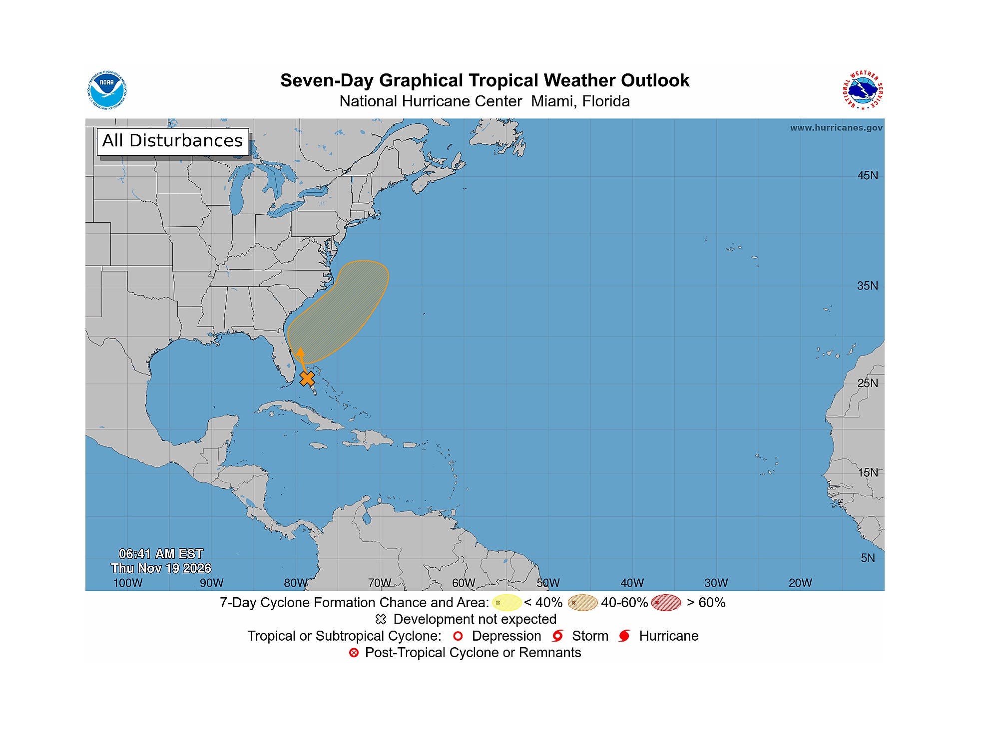
"Even if this does happen, it's likely the storm will be transitioning to a post-tropical system as it reaches our latitude," forecasters said.
"Nevertheless, strong winds, heavy rainfall, and coastal flooding are potential impacts."
Ahead of the weekend storm, Thursday is expected to be sunny and dry with highs mainly in the 60s and southwest winds around 5-10 MPH.
Similarly, Friday and Saturday are expected to be mostly sunny, with highs remaining in the 60s.
Here's the latest forecast from the National Weather Service:
NORTH JERSEY
- Thursday: Sunny, with a high near 63. Light west wind.
- Thursday Night: Mostly clear, with a low around 42. Light southwest wind.
- Friday: Sunny, with a high near 66. West wind 3-6 MPH.
- Friday Night: Mostly clear, with a low around 42. Light and variable wind.
- Saturday: Sunny, with a high near 60. Light and variable wind.
- Saturday Night: Mostly cloudy, with a low around 46.
- Sunday: A 30 percent chance of rain after 1 p.m. Mostly cloudy, with a high near 60.
- Sunday Night: Rain likely. Mostly cloudy, with a low around 51. Chance of precipitation is 70%.
CENTRAL JERSEY
- Thursday: Sunny, with a high near 65. Southwest wind around 5 MPH.
- Thursday Night: Increasing clouds, with a low around 37. West wind around 5 MPH.
- Friday: Sunny, with a high near 66. West wind around 5 MPH.
- Friday Night: Mostly clear, with a low around 39. Calm wind.
- Saturday: Mostly sunny, with a high near 62. Calm wind becoming northeast around 5 MPH.
- Saturday Night: Mostly cloudy, with a low around 46.
- Sunday: A chance of rain after 1 p.m. Mostly cloudy, with a high near 62. Chance of precipitation is 40%.
- Sunday Night: Rain likely. Mostly cloudy, with a low around 49. Chance of precipitation is 70%.
SOUTH JERSEY
- Thursday: Sunny, with a high near 59. West wind around 5 MPH becoming south in the afternoon.
- Thursday Night: Increasing clouds, with a low around 44. Southwest wind around 5 MPH.
- Friday: Sunny, with a high near 60. Northwest wind 5-10 MPH.
- Friday Night: Partly cloudy, with a low around 47. Calm wind becoming north around 5 MPH after midnight.
- Saturday: Mostly sunny, with a high near 62. East wind 5-10 MPH.
- Saturday Night: Mostly cloudy, with a low around 52.
- Sunday: Rain likely, mainly after 1 p.m. Mostly cloudy, with a high near 63. Chance of precipitation is 60%.
- Sunday Night: Rain likely, mainly before 1 a.m. Mostly cloudy, with a low around 52. Chance of precipitation is 70%.
Get more local news delivered straight to your inbox. Sign up for free Patch newsletters and alerts.