Weather
Hazardous Weather Outlook Issued For N.J. Weekend
A hazardous weather outlook was issued in New Jersey for the weekend as rain, intense heat and Tropical Storm Gaston could impact the state.

A hazardous weather outlook was issued for the weekend in New Jersey as storms and Hurricane Gaston could impact the state, according to forecasters.
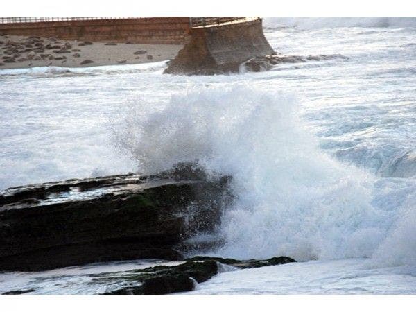
There is an increasing risk for dangerous rip currents at area beaches for much of early next week, according to an alert issued by the National Weather Service.
An air quality alert has also been issued for the central and southern areas of the state as temperatures are expected to climb close to 100 degrees.
Find out what's happening in Barnegat-Manahawkinfor free with the latest updates from Patch.
Long-period swells and waves are expected to increase in association with the storm, which is well off-shore in the Atlantic Ocean, according to the NWS.
Scattered rain showers, however, are expected to impact Burlington, Mercer, Monmouth and Ocean counties on Friday morning. Rainfall amounts will be less than a 10th of an inch.
Find out what's happening in Barnegat-Manahawkinfor free with the latest updates from Patch.
Here is the forecast for the weekend:
Friday: Isolated showers in some areas of the state before 9 a.m. Mostly cloudy, then gradually becoming sunny, with a high near 93. Southwest wind 8 to 10 mph becoming northwest in the afternoon. Chance of precipitation is 20 percent.
Friday night: Mostly clear, with a low around 66. North wind 3 to 7 mph.
Saturday: Sunny, with a high near 89. North wind around 8 mph becoming east in the afternoon.
Saturday night: Mostly clear, with a low around 63. Southeast wind 3 to 6 mph.
Sunday: Sunny, with a high near 87. East wind 5 to 8 mph.
Sunday night: Partly cloudy, with a low around 67.
Patch photo
Get more local news delivered straight to your inbox. Sign up for free Patch newsletters and alerts.