Crime & Safety
More Snowstorms Possible For Berkeley Area Next Week, Forecasters Say
The National Weather Service has released an alert, saying more snowstorms could be coming to New Jersey within the next few days.

Ready for more snow?
Benign weather to start this weekend will become more extreme during next week, and could feature a couple of storms that could have a significant impact on New Jersey.
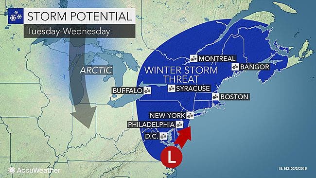
The National Weather Service has issued a Hazardous Weather Outlook, saying there is the potential for a storm coming late Monday, though the track and intensity were unknown at press time.
Find out what's happening in Berkeleyfor free with the latest updates from Patch.
The first storm could come as early as Sunday, but forecasters say there’s a better chance that snow could push eastward, and off the coast.
The Weather Channel, AccuWeather and the National Weather Service, however, say there’s a much better chance for snow coming on Monday night or Tuesday.
Find out what's happening in Berkeleyfor free with the latest updates from Patch.
Here are some details:
- The National Weather Service says snow is expected to start Monday night and spread throughout New Jersey by 1 a.m. Tuesday, possibly lasting until 1 a.m. Wednesday.
- Following near-record warmth this week, colder air will arrive in stages from the latter part of this week and into the second week of February, according to an AccuWeather release.
- The first storm will make its run near the East Coast during Sunday into Monday. Should the first storm track close to the coast, rain and/or wet snow could fall across New Jersey. Should the first storm swing well off the coast, then little or no precipitation would occur.
- The latter scenario is most likely with the early week storm. Rain will skirt the coast from the Carolinas to southeastern Virginia on Sunday.
- A second storm, however, could have significant wintry impact for the the mid-Atlantic and Northeast.
- By Tuesday, the air will likely be cold enough to support snow farther east, perhaps right to the Atlantic coast. However, how quickly that second storm forms will determine how much of the mid-Atlantic region receives accumulating snow.
- The odds of accumulating snow and the potential for a significant snowstorm will increase farther north from the upper part of the mid-Atlantic to New England spanning Tuesday into early Wednesday, according to AccuWeather.
The developing storms could bring snow for the New Hampshire primary on Tuesday.
“As with any pattern change, there is a period of uncertainty and the potential for swings in the forecast,” AccuWeather Chief Meteorologist Elliot Abrams said. “It is too early to make a call, one way or the other, until we gauge how the colder air and the two storms will interact with each other.”
Here is the National Weather Service’s forecast for the region:
Thursday: Partly sunny, with a high near 53. Northwest wind 6 to 9 mph.
Thursday night: A chance of snow, mainly after 2 a.m. Mostly cloudy, with a low around 31. North wind around 9 mph. Chance of precipitation is 30 percent. Little or no snow accumulation expected.
Friday: Mostly cloudy, then gradually becoming sunny, with a high near 41. Northwest wind 9 to 14 mph.
Friday night: Mostly clear, with a low around 24. Northwest wind 5 to 7 mph becoming calm after midnight.
Saturday: Mostly sunny, with a high near 42. Light southwest wind increasing to 5 to 10 mph in the morning.
Saturday night: Mostly cloudy, with a low around 29.
Sunday: Mostly sunny, with a high near 44.
Sunday night: Partly cloudy, with a low around 25. A chance of snow.
Monday: Partly sunny, with a high near 37.
Monday night: A chance of snow. Mostly cloudy, with a low around 27. Chance of precipitation is 30 percent.
Tuesday: A chance of snow. Mostly cloudy, with a high near 37. Chance of precipitation is 40 percent.
Tuesday night: A chance of snow. Mostly cloudy, with a low around 26. Chance of precipitation is 30 percent.
Get more local news delivered straight to your inbox. Sign up for free Patch newsletters and alerts.