Weather
Flash Flood Watch For North Jersey As Ida Approaches: Latest Info
Forecasters expect up to 6 inches of rain in some parts and potential flooding Wednesday into Thursday. Here are the latest predictions.

NORTH JERSEY — It won't be long before Tropical Depression Ida hits North Jersey, according to forecasters. The storm will bring several inches of rain and potential flash flooding into the region Wednesday and Thursday.
The tropical storm has weakened since landfall in Louisiana, and officials downgraded the event to a tropical depression Monday evening as it moved across Mississippi. Ida sustained maximum winds near 30 mph, with higher gusts, as of 3 a.m. Tuesday, according to the National Hurricane Center. The agency expects little change in the storm's strength over the next two days.
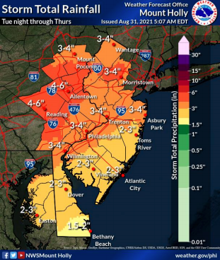
A flash flood watch is in effect for Hunterdon, Mercer, Middlesex, Morris, Somerset, Sussex and Warren Counties from 8 a.m. Wednesday to 2 p.m. Thursday, according to the National Weather Service. In that time, expect periods of scattered thunderstorms and heavy rain. Forecasters anticipate rain in the area will total 3 to 5 inches, with some local amounts exceeding 6 inches by Thursday morning.
Find out what's happening in Bloomfieldfor free with the latest updates from Patch.
The flash flood watch for Bergen, Essex, Passaic, Union and Hudson Counties runs from 2 p.m. Wednesday to 2 p.m. Thursday. The area can also expect 3 to 5 inches of rain, with precipitation sometimes reaching 1 to 2 inches per hour, according to forecasts.
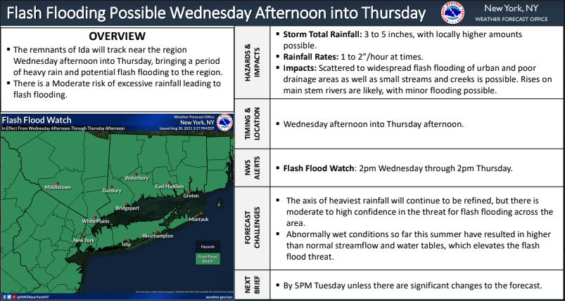
Significant floods and flash flooding are "probable," especially since the ground is saturated from recent heavy rainfall, according to the National Weather Service. Flooding is also likely for some main stem rivers, creeks and streams starting Wednesday afternoon, according to the agency.
Find out what's happening in Bloomfieldfor free with the latest updates from Patch.
Localized power outages are possible because of thunderstorms. But the National Weather Service predicts the most severe of them will occur in South Jersey.
As northeast New Jersey expects 3 to 5 inches of rainfall, here are projected totals for the rest of the state:
Here's the forecast for the Newark Liberty International Airport as of Tuesday morning, according to the National Weather Service:
- Tuesday night: A 30 percent chance of showers after 3am. Mostly cloudy, with a low around 69. West wind 3 to 8 mph.
- Wednesday: A chance of showers and thunderstorms, then showers and possibly a thunderstorm after 8am. Some of the storms could produce heavy rainfall. High near 72. Northeast wind around 6 mph. Chance of precipitation is 90%. New rainfall amounts between a half and three quarters of an inch possible.
- Wednesday night: Showers. The rain could be heavy at times. Low around 64. Northeast wind 7 to 11 mph, with gusts as high as 21 mph. Chance of precipitation is 90%. New precipitation amounts between 2 and 3 inches possible.
- Thursday: Showers likely, mainly before 2pm. Mostly cloudy, with a high near 72. North wind 11 to 14 mph, with gusts as high as 28 mph. Chance of precipitation is 60%. New precipitation amounts between 1 and 2 inches possible.
- Thursday night: A 30 percent chance of showers before 8pm. Partly cloudy, with a low around 61.
- Friday: Sunny, with a high near 77.
How to Prepare
The National Oceanic and Atmospheric Administration encourages people in Atlantic states to download the FEMA mobile app. Find tips for hurricane preparedness at ready.gov.
Atlantic hurricane season lasts from June 1 to Nov. 30. There is a 60 percent chance of an above-normal hurricane season this year, according to the NOAA.
Get more local news delivered straight to your inbox. Sign up for free Patch newsletters and alerts.